FAA INFORMATION EFFECTIVE 17 APRIL 2025
Location
| FAA Identifier: | M23 |
| Lat/Long: | 32-18-43.2250N 089-08-08.3400W
32-18.720417N 089-08.139000W
32.3120069,-89.1356500
(estimated) |
| Elevation: | 370 ft. / 113 m (estimated) |
| Variation: | 02E (1985) |
| From city: | 1 mile SE of NEWTON, MS |
| Time zone: | UTC -5 (UTC -6 during Standard Time) |
| Zip code: | 39345 |
Airport Operations
| Airport use: | Open to the public |
| Activation date: | 04/1940 |
| Control tower: | no |
| ARTCC: | MEMPHIS CENTER |
| FSS: | GREENWOOD FLIGHT SERVICE STATION |
| NOTAMs facility: | GWO (NOTAM-D service available) |
| Attendance: | /ON CALL/
CALL 601-357-0213.
FOR ATTENDANT AFT HRS & EMERG ONLY CALL 601-357-0213. |
| Wind indicator: | lighted |
| Segmented circle: | yes |
| Lights: | ACTVT MIRL RWY 14/32 - CTAF. PAPI RWY 32 OPR CONSLY. |
| Beacon: | white-green (lighted land airport)
Operates sunset to sunrise. |
Airport Communications
| CTAF/UNICOM: | 122.8 |
| WX ASOS at MEI (20 nm E): | PHONE 601-207-0082 |
Nearby radio navigation aids
| VOR radial/distance | | VOR name | | Freq | | Var |
|---|
| MEIr252/17.3 | | MERIDIAN VORTAC | | 117.00 | | 05E |
Airport Services
| Fuel available: | 100LL
100LL:24 HR FUEL AVBL WITH CREDIT CARD. |
| Parking: | tiedowns |
| Airframe service: | MAJOR
TO SKED, CALL 601-357-0115; ALSO FOR PWR PLANT RPRS. |
| Powerplant service: | MAJOR |
| Bottled oxygen: | NONE |
| Bulk oxygen: | NONE |
Runway Information
Runway 14/32
| Dimensions: | 3000 x 75 ft. / 914 x 23 m |
| Surface: | asphalt, in good condition |
| Weight bearing capacity: | |
| Runway edge lights: | medium intensity |
| Runway edge markings: | MKGS FADED. |
| RUNWAY 14 | | RUNWAY 32 |
| Latitude: | 32-18.894333N | | 32-18.546500N |
| Longitude: | 089-08.346000W | | 089-07.932000W |
| Elevation: | 370.0 ft. | | 353.0 ft. |
| Traffic pattern: | left | | left |
| Runway heading: | 133 magnetic, 135 true | | 313 magnetic, 315 true |
| Markings: | basic, in poor condition | | basic, in poor condition |
| Visual slope indicator: | pulsating/steady burning VASI on left | | pulsating/steady burning VASI on left (7.00 degrees glide path) |
| Touchdown point: | yes, no lights | | yes, no lights |
| Obstructions: | 68 ft. trees, 900 ft. from runway, 200 ft. right of centerline, 10:1 slope to clear | | 109 ft. trees, 2600 ft. from runway, 300 ft. right of centerline, 22:1 slope to clear |
Airport Ownership and Management from official FAA records
| Ownership: | Publicly-owned |
| Owner: | TOWN OF NEWTON
PO BOX 300
NEWTON, MS 39345
Phone 601-282-0828
THE HONORABLE ANTONIO HOYE, MAYOR OF NEWTON. |
| Manager: | RONALD FREDERICK
PO BOX 300
NEWTON, MS 39345
Phone 601-357-0213 |
Additional Remarks
| - | FOR CD CTC MERIDIAN APCH 601-679-3691, WHEN MERIDIAN APCH CLSD CTC MEMPHIS ARTCC AT 901-368-8453/8449. |
| - | COURTESY CAR AVBL. |
Instrument Procedures
There are no published instrument procedures at M23.
Some nearby airports with instrument procedures:
KMEI - Key Field Airport (20 nm E)
KMPE - Philadelphia Municipal Airport (29 nm N)
KNMM - Meridian Naval Air Station (Mc Cain Field) Airport (33 nm NE)
KNJW - Joe Williams Naval Outlying Field (33 nm NE)
KLUL - Hesler Airport/Noble Field (38 nm S)
|
|

Road maps at:
MapQuest
Bing
Google
| Aerial photo |
|---|
WARNING: Photo may not be current or correct

Do you have a better or more recent aerial photo of James H Easom Field Airport that you would like to share? If so, please send us your photo.
|
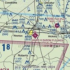
| Sectional chart |
|---|
|
| Airport distance calculator |
|---|
|
|
| Sunrise and sunset |
|---|
|
Times for 10-May-2025
| | Local
(UTC-5) | | Zulu
(UTC) |
|---|
| Morning civil twilight | | 05:37 | | 10:37 |
| Sunrise | | 06:03 | | 11:03 |
| Sunset | | 19:43 | | 00:43 |
| Evening civil twilight | | 20:09 | | 01:09 |
|
| Current date and time |
|---|
| Zulu (UTC) | 10-May-2025 19:26:22 |
|---|
| Local (UTC-5) | 10-May-2025 14:26:22 |
|---|
|
| METAR |
|---|
KMEI
20nm E | 101858Z 04009KT 2SM -RA BR BKN008 BKN021 OVC026 20/18 A2985 RMK AO2 RAB53 SLP105 P0000 T02000183 $
|
KMPE
29nm N | 101915Z AUTO 03007KT 4SM UP BKN006 OVC009 A2986 RMK AO2
|
KNMM
32nm NE | 101905Z AUTO 05005KT 10SM -RA OVC014 20/18 A2986 RMK AO2 P0000 T02000178 $
|
KNJW
33nm NE | 101857Z AUTO 03008KT 10SM BKN010 OVC013 19/17 A2991 RMK AO2 CIG 008V011 SLP042 T01890172
|
|
| TAF |
|---|
KMEI
20nm E | 101720Z 1018/1118 03011KT 4SM SHRA BR OVC011 FM101900 03006KT 3SM SHRA BR OVC007 FM102000 02006KT P6SM VCSH BKN008 FM102300 07009KT P6SM VCSH OVC008 FM110100 07007KT P6SM VCSH BKN006 FM111500 13005KT P6SM SCT006
|
|
| NOTAMs |
|---|
NOTAMs are issued by the DoD/FAA and will open in a separate window not controlled by AirNav.
|
|


