FAA INFORMATION EFFECTIVE 12 JUNE 2025
Location
| FAA Identifier: | NHK |
| Lat/Long: | 38-17-10.8010N 076-24-35.8970W
38-17.180017N 076-24.598283W
38.2863336,-76.4099714
(estimated) |
| Elevation: | 38.6 ft. / 11.8 m (surveyed) |
| Variation: | 10W (1985) |
| Time zone: | UTC -4 (UTC -5 during Standard Time) |
| Zip code: | 20670 |
Airport Operations
| Airport use: | Private use. Permission required prior to landing |
| Activation date: | 02/1944 |
| Control tower: | yes |
| ARTCC: | WASHINGTON CENTER |
| FSS: | LEESBURG FLIGHT SERVICE STATION |
| NOTAMs facility: | DCA (NOTAM-D service available) |
| Attendance: | 1200-0400Z++.
CLSD HOLIDAYS. |
| Segmented circle: | no |
| Lights: | AVBL ONLY DURING HRS OF OPERATION. |
| Beacon: | white-white-green (lighted military airport)
Operates sunset to sunrise. |
| International operations: | customs landing rights airport |
Airport Communications
| ATIS: | 322.425 |
| PATUXENT GROUND: | 120.6 336.4 [24 HRS++ MON-SUN, OTHER TIMES BY NOTAM.] |
| PATUXENT TOWER: | 123.7 343.65 340.2X [24 HRS++ MON-SUN, OTHER TIMES BY NOTAM.] |
| PATUXENT APPROACH: | 120.05 ;165-055 ABV 3000 FT 121.0 ;165-055 3000 FT & BLW 127.95 ;056-164 ALL ALTS 250.3 ;165-055 3000 FT & BLW 281.8 ;165-055 ABV 3000 FT 314.0 ;056-164 ALL ALTS [1200-0400Z++ MON-SUN. OTHER TIMES BY NOTAM.] |
| POTOMAC APPROACH: | 135.625 ;WHEN NHK APCH CLSD [0400-1200Z++ MON-SUN. OTHER TIMES BY NOTAM.] |
| PATUXENT DEPARTURE: | 120.05 ;165-055 ABV 3000 FT 121.0 ;165-055 3000 FT & BLW 127.95 ;056-164 ALL ALTS 250.3 ;165-055 3000 FT & BLW 281.8 ;165-055 ABV 3000 FT 314.0 ;056-164 ALL ALTS [1200-0400Z++ MON-SUN. OTHER TIMES BY NOTAM.] |
| POTOMAC DEPARTURE: | 135.625 ;WHEN NHK APCH CLSD [0400-1200Z++ MON-SUN. OTHER TIMES BY NOTAM.] |
| CLEARANCE DELIVERY: | 135.2 316.125 |
| EMERG: | 121.5 243.0 |
| PMSV METRO: | 356.2 |
| WX AWOS-3 at 2W6 (7 nm W): | 119.575 (301-373-6514) |
- APCH/DEP SVC PRVDD BY POTOMAC TRACON (PCT) APP/DEP CON 135.625/269.625 (MON-SUN 0400-1200Z, OTHER TIMES BY NOTAM).
- SEE TERMINAL FLIP FOR RADAR MINIMA. ASR-11, PAR.
Nearby radio navigation aids
| VOR radial/distance | | VOR name | | Freq | | Var |
|---|
| ADWr156/37.9 | | ANDREWS VORTAC | | 113.10 | | 10W |
| NDB name | | Hdg/Dist | | Freq | | Var | | ID |
|---|
| PATUXENT | | at field | | 400 | | 10W | | NHK | -. .... -.- |
| DAVEE | | 133/39.9 | | 223 | | 09W | | DAA | -.. .- .- |
Airport Services
Runway Information
Runway 6/24
| Dimensions: | 11799 x 200 ft. / 3596 x 61 m |
| Surface: | asphalt, in good condition |
| Weight bearing capacity: | |
| Runway edge lights: | high intensity |
| RUNWAY 6 | | RUNWAY 24 |
| Latitude: | 38-16.614038N | | 38-17.885825N |
| Longitude: | 076-25.297688W | | 076-23.432432W |
| Elevation: | 38.6 ft. | | 19.6 ft. |
| Traffic pattern: | left | | left |
| Runway heading: | 059 magnetic, 049 true | | 239 magnetic, 229 true |
| Markings: | precision, in good condition | | precision, in good condition |
| Approach lights: | ALSF1: standard 2,400 foot high intensity approach lighting system with centerline sequenced flashers (category I)
OLS. | | OLS. |
| Centerline lights: | yes | | yes |
| Touchdown point: | yes, lighted | | yes, no lights |
| Instrument approach: | ILS/DME | | |
Runway 14/32
| Dimensions: | 9732 x 200 ft. / 2966 x 61 m |
| Surface: | asphalt, in good condition |
| Weight bearing capacity: | |
| Runway edge lights: | high intensity |
| RUNWAY 14 | | RUNWAY 32 |
| Latitude: | 38-17.657242N | | 38-16.715505N |
| Longitude: | 076-25.400057W | | 076-23.753547W |
| Elevation: | 26.9 ft. | | 15.6 ft. |
| Traffic pattern: | left | | left |
| Runway heading: | 136 magnetic, 126 true | | 316 magnetic, 306 true |
| Markings: | precision, in good condition | | precision, in good condition |
| Approach lights: | OLS. | | OLS. |
| Touchdown point: | yes, no lights | | yes, no lights |
Runway 2/20
| Dimensions: | 5021 x 75 ft. / 1530 x 23 m |
| Surface: | asphalt, in good condition |
| Weight bearing capacity: | |
| RUNWAY 2 | | RUNWAY 20 |
| Latitude: | 38-16.593767N | | 38-17.412677N |
| Longitude: | 076-25.262207W | | 076-25.113447W |
| Elevation: | 37.2 ft. | | 24.6 ft. |
| Traffic pattern: | left | | left |
| Runway heading: | 018 magnetic, 008 true | | 198 magnetic, 188 true |
| Markings: | nonprecision, in good condition | | nonprecision, in good condition |
| Touchdown point: | yes, no lights | | yes, no lights |
Airport Ownership and Management from official FAA records
| Ownership: | U.S. Navy |
| Owner: | US NAVY
OCEANOGRAPHIC OFC-CODE 3142
WASHINGTON, DC 20373 |
| Manager: | COMMANDING OFFICER
NAVAL AIR STATION
PATUXENT RIVER, MD 20670-5409
Phone 301-863-3339 |
Additional Remarks
| E60-32 | HOOK E28(B) (3050 FT). |
| E60-24 | HOOK E28(B) (1499 FT). |
| E60-06 | HOOK E28(B) (2180 FT). |
| E60-14 | HOOK E28(B) (1280 FT). |
| - | JASU: (GTC-85) (NCPP-105) (NC-8) (NC-10). |
| - | NS ABTMT: MIL ACFT MAINT AT LEAST 1500 FT BTN 3 NM AND 10 NM FR 210 DEG CW TO 240 DEG. NO PRACTICE APCH 0300Z++ TO 1200Z++ MON-FRI, SAT BEFORE 1500Z++, SUN BEFORE 1700Z++. TRAN ACFT PRACTICE APCH NOT TO INTERFERE BASIS. |
| - | CSTMS/AG/IMG: LTD TO ACFT ON OFFICIAL BUSINESS AT PAX RIV WITH 72 HR PN. CTC AODO AT DSN 342-3836, C301-342-3836. |
| - | MISC: WX FCST SVC AVBL 0900-0100Z++ MON-FRI. FOR FCST SVC ALL OT CTC FWC-N AT DSN 565-4555 OR C888-745-6899. WX OBSN AND PMSV MTR AVBL 1100-0400Z++ MON-FRI AND 1200-2300Z++ SAT-SUN. |
| - | FOR CD WHEN NHK ATCT/APCH ARE CLSD CTC POTOMAC APCH AT 866-640-4124. |
| - | MISC: FOR INFO REGARDING CIVIL AIR LANDING PERMITS (CALPS) CTC AFM AT 301-342-8923 OR EMAIL NASPATUXENTRIVERCALPS@US.NAVY.MIL. |
| - | SERVICE: NO BASE TRANSPORTATION AVBL. |
| - | MISC: NS NORFOLK, CHAMBERS FLD COORD ALL FLT PLANNING SVC. FLT PLANS SHOULD BE EMAILED TO W_CNI_NRFK_NSNORFOLK_N32_ATC_USERS@NAVY.MIL OR FAX TO DSN 565-9680, C757-445-9680. TO CONFIRM RECEIPT OF FLT PLANS CALL NS NORFOLK, CHAMBERS FLD FLT PLANNING SUPERVISOR AT DSN 232-3419/3429, C757-322-3419/3429. |
| - | MISC: CLASS D AVAIL EXCLUDING THAT AIRSPACE WITHIN RESTRICTED AREAS R-4005 AND R-4007 WHEN ACTIVE. SEE FLIP AP/1 SUPPLEMENTARY ARPT REMARKS. |
| - | FUEL: 100LL, A, J5. |
| - | FLUID: SP LHOX LOX. |
| - | OIL: O-128-133-148-156 (MIL). |
| - | TRAN ALERT: AVBL 1200-23000Z++ MON-FRI EXC HOL. |
| - | REMARKS: OPR 1200-0400Z++ MON-FRI,1300-2300Z++ SAT-SUN, CLSD HOL. SEE FLIP AP/1 SUPPLEMENTARY ARPT RMK. |
| - | RSTD: PPR-NO NOTAM TRML FAC AVBL. PPR REQUESTS SHOULD BE EMAILED TO PAXPPRS@US.NAVY.MIL TO CONFIRM RECEIPT OF PPRS CALL DSN 342-8923, C301-342-8923. ACFT MUST MAKE PRIOR ARNG AND RCV PPR FR HOST SQUADRON, OR NAS AIR OPERATONS. LTD RAMP SPACE, AND LTD TRAN SVC AVBL EXPECT DELAYS. TWY ALL EXP DLY DUE TO ACFT WT LIMITATIONS. |
| - | CAUTION: STOPPING IN RSTD AREA ON TWY A, W TWY IS PROH. PORTIONS OF RWY, TWY AND ACFT RAMPS NOT VIS FR TWR. FIRST 1630 FT. RWY 32 MAY BE CLSD DALGT HR MON-SAT DUR VFR. BUILDINGS AND EQUIPMENT ARE LOCATED NEAR THE APPROACH END OF RWY 32. DEER AND BIRD HAZ. |
| - | TFC PAT: VFR INITIAL AT 4 DME (RWY 32 AT 3 DME) 2000 FT, BREAK 1500 FT, DOWNWIND 1000 FT. REDUCED RWY SEPARATION STD IN EFF FOR LCL BASED USN/USMC ACFT. |
Instrument Procedures
NOTE: All procedures below are presented as PDF files. If you need a reader for these files, you should download the free Adobe Reader.NOT FOR NAVIGATION. Please procure official charts for flight.
FAA instrument procedures published for use from 12 June 2025 at 0901Z to 10 July 2025 at 0900z.
IAPs - Instrument Approach Procedures |
|---|
| ILS OR LOC/DME RWY 06 | |
download (177KB) |
| RNAV (GPS) RWY 06 | |
download (110KB) |
| RNAV (GPS) RWY 14 | |
download (90KB) |
| RNAV (GPS) RWY 24 | |
download (98KB) |
| RNAV (GPS) RWY 32 | |
download (115KB) |
| HI-TACAN Y RWY 06 | |
download (241KB) |
| HI-TACAN Y RWY 14 | |
download (277KB) |
| HI-TACAN Y RWY 24 | |
download (187KB) |
| HI-TACAN Y RWY 32 | |
download (223KB) |
| TACAN Z RWY 06 | |
download (191KB) |
| TACAN Z RWY 14 | |
download (224KB) |
| TACAN Z RWY 24 | |
download (178KB) |
| TACAN Z RWY 32 | |
download (184KB) |
| NDB/DME RWY 06 | |
download (171KB) |
| Radar Approach Procedures available | |
download (160KB) |
Departure Procedures |
|---|
| SWABY NINE **CHANGED** | |
2 pages:
[1] [2] (182KB) |
| NOTE: Special Take-Off Minimums/Departure Procedures apply | |
download (357KB) |
Other nearby airports with instrument procedures:
2W6 - St Mary's County Regional Airport (7 nm W)
KCGE - Cambridge-Dorchester Regional Airport (23 nm NE)
W41 - Crisfield-Somerset County Airport (32 nm SE)
KTGI - Tangier Island Airport (34 nm SE)
KXSA - Tappahannock/Essex County Airport (34 nm SW)
|
|

Road maps at:
MapQuest
Bing
Google
| Aerial photo |
|---|
WARNING: Photo may not be current or correct
 Photo taken 12-Aug-2006
Do you have a better or more recent aerial photo of Patuxent River Naval Air Station (Trapnell Field) Airport that you would like to share? If so, please send us your photo.
|
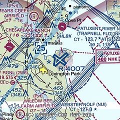
| Sectional chart |
|---|
|
 Download PDF
of official airport diagram from the FAA
| Airport distance calculator |
|---|
|
|
| Sunrise and sunset |
|---|
|
Times for 05-Jul-2025
| | Local
(UTC-4) | | Zulu
(UTC) |
|---|
| Morning civil twilight | | 05:18 | | 09:18 |
| Sunrise | | 05:49 | | 09:49 |
| Sunset | | 20:31 | | 00:31 |
| Evening civil twilight | | 21:03 | | 01:03 |
|
| Current date and time |
|---|
| Zulu (UTC) | 05-Jul-2025 19:16:27 |
|---|
| Local (UTC-4) | 05-Jul-2025 15:16:27 |
|---|
|
| METAR |
|---|
| KNHK | 051852Z 12009KT 10SM FEW045 FEW300 31/17 A3016 RMK AO2 SLP212 T03060172 $
|
K2W6
7nm W | 051900Z AUTO 11007KT 10SM SCT050 28/16 A3017 RMK AO1
|
KNUI
9nm S | 051753Z AUTO 18008G14KT 170V230 10SM FEW045 28/18 A3017 RMK AO2 SLP215 T02830183 10289 20239 50000 $
|
|
| TAF |
|---|
| KNHK | 0516/0616 VRB06KT 9999 FEW040 FEW250 QNH3012INS FM052100 16010KT 9999 FEW250 QNH3004INS FM061000 VRB06KT 9999 FEW200 QNH3000INS TX29/0519Z TN23/0609Z FN00291
|
|
| NOTAMs |
|---|
NOTAMs are issued by the DoD/FAA and will open in a separate window not controlled by AirNav.
|
|


