FAA INFORMATION EFFECTIVE 18 APRIL 2024
Location
| FAA Identifier: | PIR |
| Lat/Long: | 44-22-57.7000N 100-17-09.5000W
44-22.961667N 100-17.158333W
44.3826944,-100.2859722
(estimated) |
| Elevation: | 1744.3 ft. / 531.7 m (surveyed) |
| Variation: | 08E (2000) |
| From city: | 3 miles E of PIERRE, SD |
| Time zone: | UTC -5 (UTC -6 during Standard Time) |
| Zip code: | 57501 |
Airport Operations
| Airport use: | Open to the public |
| Activation date: | 12/1937 |
| Control tower: | no |
| ARTCC: | MINNEAPOLIS CENTER |
| FSS: | HURON FLIGHT SERVICE STATION |
| NOTAMs facility: | PIR (NOTAM-D service available) |
| Attendance: | MON-FRI 0500-2400, ALL SAT-SUN 0500-2200
FOR ATTENDANT OTHER TIMES CALL 605-224-9000/8621. |
| Wind indicator: | lighted |
| Segmented circle: | yes |
| Lights: | ACTVT MALSR RWY 31; REIL RWY 07, 13, 25; PAPI RWY 07, 25, 13 & 31; HIRL RWY 07/25 & 13/31 -CTAF. |
| Beacon: | white-green (lighted land airport)
Operates sunset to sunrise. |
| Landing fee: | no, NO |
| Fire and rescue: | ARFF index B |
| Airline operations: | 48 HOUR PPR FOR UNSKED ACR OPNS INVOLVING ACFT DESIGNED FOR 31 OR MORE PAX SEATS CALL 605-773-7447 OR 605-773-7405. |
Airport Communications
| CTAF: | 122.7 |
| UNICOM: | 122.95 |
| WX ASOS: | 119.025 (605-224-6087) |
- APCH/DEP SVC PRVDD BY MINNEAPOLIS ARTCC ON FREQS 125.1/269.1 (PIERRE RCAG).
Nearby radio navigation aids
| VOR radial/distance | | VOR name | | Freq | | Var |
|---|
| PIRr251/5.3 | | PIERRE VORTAC | | 113.75 | | 11E |
Airport Services
| Fuel available: | 100LL JET-A |
| Parking: | hangars and tiedowns |
| Airframe service: | MAJOR |
| Powerplant service: | MAJOR |
| Bottled oxygen: | HIGH/LOW |
| Bulk oxygen: | HIGH/LOW |
Runway Information
Runway 13/31
| Dimensions: | 6900 x 100 ft. / 2103 x 30 m |
| Surface: | asphalt/grooved, in good condition |
| Weight bearing capacity: | | PCN 51 /F/C/W/T | | Single wheel: | 91.0 | | Double wheel: | 108.0 | | Double tandem: | 168.0 |
|
| Runway edge lights: | high intensity |
| RUNWAY 13 | | RUNWAY 31 |
| Latitude: | 44-23.093112N | | 44-22.215077N |
| Longitude: | 100-17.628973W | | 100-16.625072W |
| Elevation: | 1730.8 ft. | | 1717.7 ft. |
| Traffic pattern: | left | | left |
| Runway heading: | 133 magnetic, 141 true | | 313 magnetic, 321 true |
| Declared distances: | TORA:6900 TODA:6900 ASDA:6900 LDA:6900 | | TORA:6900 TODA:6900 ASDA:6900 LDA:6900 |
| Markings: | precision, in good condition | | precision, in good condition |
| Visual slope indicator: | 4-light PAPI on left (3.00 degrees glide path) | | 4-light PAPI on left (3.00 degrees glide path) |
| Approach lights: | | | MALSR: 1,400 foot medium intensity approach lighting system with runway alignment indicator lights |
| Runway end identifier lights: | yes | | no |
| Touchdown point: | yes, no lights | | yes, no lights |
| Instrument approach: | | | ILS/DME |
Runway 7/25
| Dimensions: | 6880 x 150 ft. / 2097 x 46 m |
| Surface: | asphalt/grooved, in good condition |
| Weight bearing capacity: | | PCN 58 /F/C/W/T | | Single wheel: | 91.0 | | Double wheel: | 114.0 | | Double tandem: | 180.0 |
|
| Runway edge lights: | high intensity |
| RUNWAY 7 | | RUNWAY 25 |
| Latitude: | 44-23.143427N | | 44-23.394965N |
| Longitude: | 100-17.959928W | | 100-16.420427W |
| Elevation: | 1744.3 ft. | | 1702.6 ft. |
| Traffic pattern: | left | | left |
| Runway heading: | 069 magnetic, 077 true | | 249 magnetic, 257 true |
| Declared distances: | TORA:6880 TODA:6880 ASDA:6830 LDA:6830 | | TORA:6880 TODA:6880 ASDA:6880 LDA:6880 |
| Markings: | nonprecision, in good condition | | nonprecision, in good condition |
| Visual slope indicator: | 4-light PAPI on left (3.00 degrees glide path) | | 4-light PAPI on left (3.00 degrees glide path) |
| Runway end identifier lights: | yes | | yes |
| Touchdown point: | yes, no lights | | yes, no lights |
| Obstructions: | 79 ft. tank, lighted, 3158 ft. from runway, 548 ft. left of centerline, 37:1 slope to clear | | none |
Airport Ownership and Management from official FAA records
| Ownership: | Publicly-owned |
| Owner: | CITY OF PIERRE
3800 AIRPORT ROAD, SUITE 209
PIERRE, SD 57501
Phone 605-773-7447 |
| Manager: | BRIAN COWLES
3800 AIRPORT ROAD, SUITE 209
PIERRE, SD 57501
Phone 605-773-7447 |
Airport Operational Statistics
| Aircraft based on the field: | | 65 | | Single engine airplanes: | | 50 | | Multi engine airplanes: | | 12 | | Jet airplanes: | | 1 | | Helicopters: | | 2 |
| |  | |
| Aircraft operations: avg 88/day * | | 47% | transient general aviation | | 23% | local general aviation | | 23% | air taxi | | 5% | commercial | | 2% | military | | * for 12-month period ending 13 September 2019 | |
Additional Remarks
| - | BIRDS ON & INVOF ARPT & WITHIN A 25 NM RADIUS. |
| - | TWY C IS 50 FT WIDE & RSTRD TO ACFT 75000 LBS OR LESS. |
| - | NO LINE OF SIGHT BTN RY ENDS OF RY 07/25. |
| - | ARPT COND UNMONITORED DURING 2200-0600 MON-FRI; 1300 SAT - 1300 SUN. |
| - | AIR CARRIER LANDING FEE $14 + $1 PER 1000 LBS OVER 20K LBS |
| - | FOR CD IF UNA TO CTC ON FSS FREQ, CTC MINNEAPOLIS ARTCC AT 651-463-5588. |
Instrument Procedures
NOTE: All procedures below are presented as PDF files. If you need a reader for these files, you should download the free Adobe Reader.NOT FOR NAVIGATION. Please procure official charts for flight.
FAA instrument procedures published for use from 18 April 2024 at 0901Z to 16 May 2024 at 0900Z.
IAPs - Instrument Approach Procedures |
|---|
| ILS OR LOC RWY 31 | |
download (259KB) |
| RNAV (GPS) RWY 07 | |
download (239KB) |
| RNAV (GPS) RWY 13 | |
download (253KB) |
| RNAV (GPS) RWY 25 | |
download (264KB) |
| RNAV (GPS) RWY 31 | |
download (243KB) |
| VOR/DME OR TACAN RWY 07 | |
download (245KB) |
| VOR OR TACAN RWY 25 | |
download (218KB) |
| NOTE: Special Alternate Minimums apply | |
download (162KB) |
| NOTE: Special Take-Off Minimums/Departure Procedures apply | |
download (156KB) |
Other nearby airports with instrument procedures:
98D - Onida Municipal Airport (21 nm N)
9D0 - Highmore Municipal Airport (37 nm E)
0D8 - Gettysburg Municipal Airport (39 nm N)
84D - Cheyenne Eagle Butte Airport (55 nm NW)
9V9 - Chamberlain Municipal Airport (56 nm SE)
|
|

Road maps at:
MapQuest
Bing
Google
| Aerial photo |
|---|
WARNING: Photo may not be current or correct
 Photo courtesy of AirNav, LLC
Photo taken 11-Sep-2012
looking south.
Photo courtesy of AirNav, LLC
Photo taken 11-Sep-2012
looking south.
Do you have a better or more recent aerial photo of Pierre Regional Airport that you would like to share? If so, please send us your photo.
|
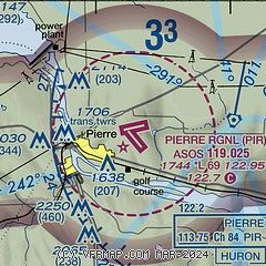
| Sectional chart |
|---|
|
| Airport distance calculator |
|---|
|
|
| Sunrise and sunset |
|---|
|
Times for 19-Apr-2024
| | Local
(UTC-5) | | Zulu
(UTC) |
|---|
| Morning civil twilight | | 06:19 | | 11:19 |
| Sunrise | | 06:50 | | 11:50 |
| Sunset | | 20:30 | | 01:30 |
| Evening civil twilight | | 21:01 | | 02:01 |
|
| Current date and time |
|---|
| Zulu (UTC) | 19-Apr-2024 07:50:17 |
|---|
| Local (UTC-5) | 19-Apr-2024 02:50:17 |
|---|
|
| METAR |
|---|
| KPIR | 190653Z AUTO 28005KT 10SM CLR M02/M06 A3022 RMK AO2 SLP248 T10171061
|
|
| TAF |
|---|
| KPIR | 190520Z 1906/2006 26004KT P6SM SKC FM190900 29010G16KT P6SM SKC FM191300 29015G24KT P6SM SKC FM191600 30021G31KT P6SM FEW160 FM192300 32022G33KT P6SM SCT100 FM200200 32015G23KT P6SM FEW230
|
|
| NOTAMs |
|---|
NOTAMs are issued by the DoD/FAA and will open in a separate window not controlled by AirNav.
|
|


