FAA INFORMATION EFFECTIVE 25 DECEMBER 2025
Location
| FAA Identifier: | S21 |
| Lat/Long: | 43-52-34.7250N 121-27-10.9850W
43-52.578750N 121-27.183083W
43.8763125,-121.4530514
(estimated) |
| Elevation: | 4163.5 ft. / 1269.0 m (surveyed) |
| Variation: | 14E (2025) |
| From city: | 1 mile W of SUNRIVER, OR |
| Time zone: | UTC -8 (UTC -7 during Daylight Saving Time) |
| Zip code: | 97707 |
Airport Operations
| Airport use: | Open to the public |
| Activation date: | 05/1969 |
| Control tower: | no |
| ARTCC: | SEATTLE CENTER |
| FSS: | MC MINNVILLE FLIGHT SERVICE STATION |
| NOTAMs facility: | MMV (NOTAM-D service available) |
| Attendance: | MAY 15 - 14 OCT 0700-1900, 15 OCT - 14 MAY 0800-1800 |
| Wind indicator: | lighted |
| Segmented circle: | yes |
| Lights: | ACTVT REIL RWY 18 & 36; PAPI RWY 18 & 36; MIRL RWY 18/36 - CTAF. |
| Beacon: | white-green (lighted land airport)
ACTVT ROTG BCN - CTAF. |
Airport Communications
| CTAF/UNICOM: | 122.8 |
| WX AWOS-3PT: | 128.325 (541-593-4623) |
| WX AWOS-3 at BDN (17 nm NE): | 134.425 (541-382-1477) |
- APCH/DEP CTL SVC PRVDD BY SEATTLE ARTCC (ZSE) ON FREQS 126.15/269.475 (REDMOND RCAG).
- COMMUNICATIONS PRVDD BY MC MINNVILLE RADIO ON FREQ 122.3 (SUNRIVER RCO).
Nearby radio navigation aids
| VOR radial/distance | | VOR name | | Freq | | Var |
|---|
| DSDr178/23.5 | | DESCHUTES VORTAC | | 117.60 | | 18E |
Airport Services
| Fuel available: | 100LL JET-A JET-A+ |
| Parking: | hangars and tiedowns |
| Powerplant service: | NONE |
| Bottled oxygen: | NONE |
| Bulk oxygen: | NONE |
Runway Information
Runway 18/36
| Dimensions: | 5460 x 75 ft. / 1664 x 23 m |
| Surface: | asphalt, in excellent condition |
| Weight bearing capacity: | |
| Runway edge lights: | medium intensity |
| Runway edge markings: | THRESHOLD LIGHTS LOCATED 148 FT NORTH OF ACTUAL RUNWAY END |
| RUNWAY 18 | | RUNWAY 36 |
| Latitude: | 43-53.010780N | | 43-52.146703N |
| Longitude: | 121-27.012838W | | 121-27.353302W |
| Elevation: | 4158.7 ft. | | 4163.5 ft. |
| Traffic pattern: | right | | left |
| Runway heading: | 182 magnetic, 196 true | | 002 magnetic, 016 true |
| Displaced threshold: | 156 ft. | | no |
| Markings: | nonprecision, in good condition | | basic, in good condition |
| Visual slope indicator: | 4-light PAPI on left (3.50 degrees glide path) | | 4-light PAPI on left (3.50 degrees glide path) |
| Runway end identifier lights: | yes | | yes |
| Touchdown point: | yes, no lights | | yes, no lights |
| Obstructions: | none
RWY 18 APCH RATIO 54:1 BASED ON DSPLCD THLD; +70 FT TREES 4000 FT ON CNTRLN. | | 80 ft. trees, 2000 ft. from runway, 150 ft. both sides of centerline, 22:1 slope to clear |
Airport Ownership and Management from official FAA records
| Ownership: | Privately-owned |
| Owner: | SUNRIVER RESORT, L.P.
PO BOX 3609
SUNRIVER, OR 97707
Phone 541-593-1000 |
| Manager: | BRANDON WRIGHT
57200 RIVER ROAD
SUNRIVER, OR 97707
Phone 541-593-4603 |
Additional Remarks
| - | FOR NOISE ABATEMENT DEPARTING ACFT ARE URGED TO CLIMB WEST OF ARPT PRIOR TO TURNING ON COURSE. |
| - | FLOCKS OF WATERFOWL INVOF ARPT. |
| - | FOR CD IF UNA TO CTC ON FSS FREQ, CTC SEATTLE ARTCC AT 253-351-3694. |
Instrument Procedures
NOTE: All procedures below are presented as PDF files. If you need a reader for these files, you should download the free Adobe Reader.NOT FOR NAVIGATION. Please procure official charts for flight.
FAA instrument procedures published for use from 25 December 2025 at 0901z to 22 January 2026 at 0900z.
IAPs - Instrument Approach Procedures |
|---|
| RNAV (GPS) RWY 18 | |
download (290KB) |
| NOTE: Special Alternate Minimums apply | |
download (208KB) |
| NOTE: Special Take-Off Minimums/Departure Procedures apply | |
download (555KB) |
Other nearby airports with instrument procedures:
KBDN - Bend Municipal Airport (17 nm NE)
KRDM - Roberts Field Airport (26 nm NE)
S39 - Prineville Airport (34 nm NE)
S33 - Madras Municipal Airport (49 nm N)
62S - Christmas Valley Airport (51 nm SE)
|
|

Road maps at:
MapQuest
Bing
Google
| Aerial photo |
|---|
WARNING: Photo may not be current or correct
 Photo taken 17-Mar-2020
from 6000' msl looking south.
Photo taken 17-Mar-2020
from 6000' msl looking south.
Do you have a better or more recent aerial photo of Sunriver Airport that you would like to share? If so, please send us your photo.
|
| Sectional chart |
|---|
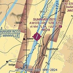
|
| Airport distance calculator |
|---|
|
|
| Sunrise and sunset |
|---|
|
Times for 06-Jan-2026
| | Local
(UTC-8) | | Zulu
(UTC) |
|---|
| Morning civil twilight | | 07:08 | | 15:08 |
| Sunrise | | 07:41 | | 15:41 |
| Sunset | | 16:43 | | 00:43 |
| Evening civil twilight | | 17:15 | | 01:15 |
|
| Current date and time |
|---|
| Zulu (UTC) | 07-Jan-2026 03:34:49 |
|---|
| Local (UTC-8) | 06-Jan-2026 19:34:49 |
|---|
|
| METAR |
|---|
| KS21 | 070315Z AUTO 20011G19KT 10SM -UP SCT026 BKN037 OVC047 02/M02 A2987 RMK AO2
|
KBDN
17nm NE | 070315Z AUTO 20015G21KT 10SM FEW033 SCT041 BKN090 05/M02 A2981 RMK AO2
|
|
| TAF |
|---|
KBDN
17nm NE | 061759Z 0618/0718 20012KT P6SM OVC070 FM062000 20015G25KT P6SM OVC050 FM070200 21019G28KT P6SM -RA BKN045 WS020/25045KT FM070900 21012G20KT P6SM -RA BKN060 FM071100 20008KT P6SM -RA OVC040
|
|
| NOTAMs |
|---|
NOTAMs are issued by the DoD/FAA and will open in a separate window not controlled by AirNav.
|
|

