FAA INFORMATION EFFECTIVE 16 APRIL 2026
Location
| FAA Identifier: | S33 |
| Lat/Long: | 44-40-12.5880N 121-09-18.5370W
44-40.209800N 121-09.308950W
44.6701633,-121.1551492
(estimated) |
| Elevation: | 2437.6 ft. / 743.0 m (surveyed) |
| Variation: | 16E (2010) |
| From city: | 3 miles NW of MADRAS, OR |
| Time zone: | UTC -7 (UTC -8 during Standard Time) |
| Zip code: | 97741 |
Airport Operations
| Airport use: | Open to the public |
| Activation date: | 12/1938 |
| Control tower: | no |
| ARTCC: | SEATTLE CENTER |
| FSS: | MC MINNVILLE FLIGHT SERVICE STATION |
| NOTAMs facility: | MMV (NOTAM-D service available) |
| Attendance: | MON-FRI 0800-1700, ALL SAT-SUN 0900-1400 |
| Wind indicator: | lighted |
| Segmented circle: | no |
| Lights: | ACTVT REIL RWY 34; VASI RWY 34; MRIL RWY 16/34 - CTAF |
| Beacon: | white-green (lighted land airport)
Operates sunset to sunrise. |
Airport Communications
| CTAF/UNICOM: | 122.8 |
| WX AWOS-3PT: | 132.425 (541-475-0494) |
- APCH/DEP CTL SVC PRVDD BY SEATTLE ARTCC (ZSE) ON FREQ 126.15/269.475 (REDMOND RCAG).
Nearby radio navigation aids
| VOR radial/distance | | VOR name | | Freq | | Var |
|---|
| DSDr356/25.8 | | DESCHUTES VORTAC | | 117.60 | | 18E |
Airport Services
| Fuel available: | 100LL JET-A |
| Parking: | hangars and tiedowns |
| Airframe service: | MAJOR |
| Powerplant service: | MAJOR |
| Bottled oxygen: | HIGH/LOW |
| Bulk oxygen: | NONE |
Runway Information
Runway 16/34
| Dimensions: | 5091 x 75 ft. / 1552 x 23 m |
| Surface: | asphalt, in good condition |
| Weight bearing capacity: | | Single wheel: | 75.0 | | Double wheel: | 120.0 | | Double tandem: | 180.0 |
|
| Runway edge lights: | medium intensity |
| RUNWAY 16 | | RUNWAY 34 |
| Latitude: | 44-40.441898N | | 44-39.604173N |
| Longitude: | 121-09.203057W | | 121-09.203545W |
| Elevation: | 2430.3 ft. | | 2437.4 ft. |
| Traffic pattern: | left | | left |
| Runway heading: | 164 magnetic, 180 true | | 344 magnetic, 000 true |
| Markings: | nonprecision, in good condition | | nonprecision, in good condition |
| Visual slope indicator: | | | 4-box VASI on left (3.00 degrees glide path) |
| Runway end identifier lights: | | | yes |
| Touchdown point: | yes, no lights | | yes, no lights |
Runway 4/22
| Dimensions: | 2701 x 50 ft. / 823 x 15 m |
| Surface: | asphalt, in fair condition |
| Weight bearing capacity: | |
| Runway edge markings: | RY 04/22 MKD WITH WHITE REFLECTORS. |
| RUNWAY 4 | | RUNWAY 22 |
| Latitude: | 44-40.434423N | | 44-40.689232N |
| Longitude: | 121-09.763293W | | 121-09.252962W |
| Elevation: | 2417.0 ft. | | 2424.7 ft. |
| Traffic pattern: | left | | left |
| Runway heading: | 039 magnetic, 055 true | | 219 magnetic, 235 true |
| Markings: | basic, in fair condition | | basic, in fair condition |
| Touchdown point: | yes, no lights | | yes, no lights |
| Obstructions: | none | | 15 ft. road, 200 ft. from runway, 240 ft. right of centerline
+5 FT FENCE 190 FT FM RY END 228 FT R. |
Helipad H1
| Dimensions: | 100 x 100 ft. / 30 x 30 m |
| Surface: | asphalt |
| Latitude: | 44-40.593000N | | |
| Longitude: | 121-10.049833W | | |
| Elevation: | 2414.0 ft. | | |
| Traffic pattern: | left | | left |
| Markings: | basic, in good condition | | |
Airport Ownership and Management from official FAA records
| Ownership: | Publicly-owned |
| Owner: | CITY
125 SW E ST., CITY HALL, CITY HALL
MADRAS, OR 97741
Phone 541-475-2344 |
| Manager: | LORRAINE MARTINELLI
2028 NW BERG DR
MADRAS, OR 97741
Phone 541-777-4935 |
Additional Remarks
| A30A-H1 | TLOF DIMENSIONS 100 X 100. FATO DIMENSIONS 162 X 162. SAFETY AREA DIMENSIONS 24 X 24. PRIMARY INGRESS/EGRESS; 164/344 DEGS. |
| - | DEER, COYOTE AND COUGAR ON & INVOF ARPT. |
| - | FOR CD CTC SEATTLE ARTCC AT 253-351-3694. |
| - | COLD TEMPERATURE AIRPORT. ALTITUDE CORRECTION REQUIRED AT OR BELOW -20C. |
Instrument Procedures
NOTE: All procedures below are presented as PDF files. If you need a reader for these files, you should download the free Adobe Reader.NOT FOR NAVIGATION. Please procure official charts for flight.
FAA instrument procedures published for use from 16 April 2026 at 0901Z to 14 May 2026 at 0900Z.
IAPs - Instrument Approach Procedures |
|---|
| RNAV (GPS) RWY 16 | |
download (271KB) |
| RNAV (GPS) RWY 34 | |
download (255KB) |
| NOTE: Special Alternate Minimums apply | |
download (186KB) |
| NOTE: Special Take-Off Minimums/Departure Procedures apply | |
download (573KB) |
Other nearby airports with instrument procedures:
KRDM - Roberts Field Airport (25 nm S)
S39 - Prineville Airport (25 nm SE)
KBDN - Bend Municipal Airport (35 nm S)
S21 - Sunriver Airport (49 nm S)
KDLS - Columbia Gorge Regional/The Dalles Municipal Airport (57 nm N)
|
|

Road maps at:
MapQuest
Bing
Google
| Aerial photo |
|---|
WARNING: Photo may not be current or correct

Do you have a better or more recent aerial photo of Madras Municipal Airport that you would like to share? If so, please send us your photo.
|
| Sectional chart |
|---|
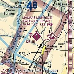
|
| Airport distance calculator |
|---|
|
|
| Sunrise and sunset |
|---|
|
Times for 02-May-2026
| | Local
(UTC-7) | | Zulu
(UTC) |
|---|
| Morning civil twilight | | 05:22 | | 12:22 |
| Sunrise | | 05:54 | | 12:54 |
| Sunset | | 20:09 | | 03:09 |
| Evening civil twilight | | 20:42 | | 03:42 |
|
| Current date and time |
|---|
| Zulu (UTC) | 03-May-2026 05:44:24 |
|---|
| Local (UTC-7) | 02-May-2026 22:44:24 |
|---|
|
| METAR |
|---|
| KS33 | 030535Z AUTO 13007KT 10SM CLR 12/06 A2998 RMK AO2
|
|
| TAF |
|---|
KRDM
25nm S | 021720Z 0218/0318 VRB05KT P6SM BKN120 FM022000 35010KT P6SM BKN150 FM030100 VRB03KT P6SM BKN250
|
|
| NOTAMs |
|---|
NOTAMs are issued by the DoD/FAA and will open in a separate window not controlled by AirNav.
|
|


