FAA INFORMATION EFFECTIVE 02 OCTOBER 2025
Location
| FAA Identifier: | S39 |
| Lat/Long: | 44-17-16.2760N 120-54-19.7910W
44-17.271267N 120-54.329850W
44.2878544,-120.9054975
(estimated) |
| Elevation: | 3251.2 ft. / 991.0 m (surveyed) |
| Variation: | 14E (2025) |
| From city: | 3 miles SW of PRINEVILLE, OR |
| Time zone: | UTC -7 (UTC -8 during Standard Time) |
| Zip code: | 97754 |
Airport Operations
| Airport use: | Open to the public |
| Activation date: | 01/1943 |
| Control tower: | no |
| ARTCC: | SEATTLE CENTER |
| FSS: | MC MINNVILLE FLIGHT SERVICE STATION |
| NOTAMs facility: | MMV (NOTAM-D service available) |
| Attendance: | SAT-SUN 0900-1400, ALL MON-FRI 0800-16:30 |
| Wind indicator: | lighted |
| Segmented circle: | yes |
| Lights: | ACTVT MIRL RWY 11/29; PAPI RWY 29 & LIRL RWY 15/33 - CTAF. |
| Beacon: | white-green (lighted land airport)
Operates sunset to sunrise. |
Airport Communications
| CTAF/UNICOM: | 122.7 |
| WX AWOS-3PT: | 118.325 (541-447-4060) |
| WX ASOS at RDM (11 nm W): | 119.025 (541-504-8743) |
| WX AWOS-3 at BDN (17 nm SW): | 134.425 (541-382-1477) |
- APCH/DEP CTL SVC PRVDD BY SEATTLE ARTCC (ZSE) ON FREQS 126.15/269.475 (REDMOND RCAG).
Nearby radio navigation aids
| VOR radial/distance | | VOR name | | Freq | | Var |
|---|
| DSDr065/17.2 | | DESCHUTES VORTAC | | 117.60 | | 18E |
Airport Services
| Fuel available: | 100LL JET-A
100LL:24 HR CARD LOCK SELF-SVC FUEL AVBL. |
| Parking: | tiedowns |
| Airframe service: | MAJOR |
| Powerplant service: | MAJOR |
| Bottled oxygen: | NONE |
| Bulk oxygen: | NONE |
Runway Information
Runway 11/29
| Dimensions: | 5405 x 75 ft. / 1647 x 23 m |
| Surface: | asphalt, in good condition |
| Weight bearing capacity: | |
| Runway edge lights: | medium intensity |
| RUNWAY 11 | | RUNWAY 29 |
| Latitude: | 44-17.602258N | | 44-17.167262N |
| Longitude: | 120-54.887550W | | 120-53.807567W |
| Elevation: | 3246.1 ft. | | 3236.6 ft. |
| Traffic pattern: | left | | left |
| Runway heading: | 105 magnetic, 119 true | | 285 magnetic, 299 true |
| Markings: | nonprecision, in good condition | | nonprecision, in good condition |
| Visual slope indicator: | | | 4-light PAPI on left (3.00 degrees glide path) |
| Touchdown point: | yes, no lights | | yes, no lights |
| Obstructions: | 25 ft. trees, 562 ft. from runway, 48 ft. right of centerline, 14:1 slope to clear | | none |
Runway 15/33
| Dimensions: | 4053 x 40 ft. / 1235 x 12 m |
| Surface: | asphalt, in poor condition
NMRS AREAS OF UNSEALED LONGL AND TRANSVERSE CRACKING THRUT FULL LEN. |
| Weight bearing capacity: | | Single wheel: | 5.0, LIMITED BY ARPT OPERATOR TO 5000 LBS MAX WEIGHT. |
|
| Runway edge lights: | low intensity |
| RUNWAY 15 | | RUNWAY 33 |
| Latitude: | 44-17.449672N | | 44-16.790113N |
| Longitude: | 120-54.375338W | | 120-54.237268W |
| Elevation: | 3239.2 ft. | | 3250.1 ft. |
| Traffic pattern: | left | | left |
| Runway heading: | 157 magnetic, 171 true | | 337 magnetic, 351 true |
| Markings: | basic, in good condition | | basic, in good condition |
| Touchdown point: | yes, no lights | | yes, no lights |
Airport Ownership and Management from official FAA records
| Ownership: | Publicly-owned |
| Owner: | PRINEVILLE /CROOK COUNTY
4585 SW AIRPORT RD.
PRINEVILLE, OR 97754
Phone 541-416-0805 |
| Manager: | KELLY COFFELT
4585 SW AIRPORT ROAD
PRINEVILLE, OR 97754
Phone 541-416-0805 |
Additional Remarks
| - | DEER ON & INVOF ARPT. |
| - | FOR CD CTC SEATTLE ARTCC AT 253-351-3694. |
| - | CALM WIND RWY 29 |
Instrument Procedures
NOTE: All procedures below are presented as PDF files. If you need a reader for these files, you should download the free Adobe Reader.NOT FOR NAVIGATION. Please procure official charts for flight.
FAA instrument procedures published for use from 02 October 2025 at 0901Z to 30 October 2025 at 0900z.
IAPs - Instrument Approach Procedures |
|---|
| RNAV (GPS) RWY 11 | |
download (231KB) |
| RNAV (GPS) RWY 29 | |
download (250KB) |
| NOTE: Special Alternate Minimums apply | |
download (184KB) |
Departure Procedures |
|---|
| DESCHUTES THREE (RNAV) | |
download (195KB) |
| NOTE: Special Take-Off Minimums/Departure Procedures apply | |
download (523KB) |
Other nearby airports with instrument procedures:
KRDM - Roberts Field Airport (11 nm W)
KBDN - Bend Municipal Airport (17 nm SW)
S33 - Madras Municipal Airport (25 nm NW)
S21 - Sunriver Airport (34 nm SW)
62S - Christmas Valley Airport (64 nm S)
|
|

Road maps at:
MapQuest
Bing
Google
| Aerial photo |
|---|
WARNING: Photo may not be current or correct
 Photo taken 20-May-2014
looking northwest.
Photo taken 20-May-2014
looking northwest.
Do you have a better or more recent aerial photo of Prineville Airport that you would like to share? If so, please send us your photo.
|
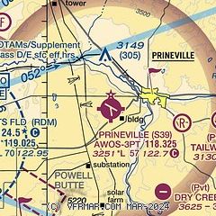
| Sectional chart |
|---|
|
| Airport distance calculator |
|---|
|
|
| Sunrise and sunset |
|---|
|
Times for 12-Oct-2025
| | Local
(UTC-7) | | Zulu
(UTC) |
|---|
| Morning civil twilight | | 06:47 | | 13:47 |
| Sunrise | | 07:16 | | 14:16 |
| Sunset | | 18:24 | | 01:24 |
| Evening civil twilight | | 18:53 | | 01:53 |
|
| Current date and time |
|---|
| Zulu (UTC) | 12-Oct-2025 15:31:28 |
|---|
| Local (UTC-7) | 12-Oct-2025 08:31:28 |
|---|
|
| METAR |
|---|
| KS39 | 121515Z AUTO 18003KT 10SM FEW050 FEW120 05/01 A2996 RMK AO2
|
KRDM
11nm W | 121456Z AUTO 12006KT 10SM CLR 04/01 A2995 RMK AO2 SLP145 T00440006 58001
|
KBDN
17nm SW | 121515Z AUTO 00000KT 10SM CLR 04/00 A2995 RMK AO2
|
|
| TAF |
|---|
KRDM
11nm W | 121138Z 1212/1312 30005KT P6SM OVC050 FM121500 24008KT P6SM OVC050 FM130000 24005KT 5SM -RA SCT025 OVC035 FM130600 14003KT P6SM -RA OVC020
|
KBDN
17nm SW | 121138Z 1212/1312 15008KT P6SM OVC050 FM121500 26010KT P6SM OVC050 FM130000 26007KT 5SM -RA SCT025 OVC035 FM130600 16004KT P6SM -RA OVC020
|
|
| NOTAMs |
|---|
NOTAMs are issued by the DoD/FAA and will open in a separate window not controlled by AirNav.
|
|

