FAA INFORMATION EFFECTIVE 16 APRIL 2026
Location
| FAA Identifier: | SBA |
| Lat/Long: | 34-25-34.2900N 119-50-29.3740W
34-25.571500N 119-50.489567W
34.4261917,-119.8414928
(estimated) |
| Elevation: | 13.5 ft. / 4.1 m (surveyed) |
| Variation: | 14E (1985) |
| From city: | 7 miles W of SANTA BARBARA, CA |
| Time zone: | UTC -7 (UTC -8 during Standard Time) |
| Zip code: | 93117 |
Airport Operations
| Airport use: | Open to the public |
| Activation date: | 04/1940 |
| Control tower: | yes |
| ARTCC: | LOS ANGELES CENTER |
| FSS: | HAWTHORNE FLIGHT SERVICE STATION |
| NOTAMs facility: | SBA (NOTAM-D service available) |
| Attendance: | 0600-2300 |
| Pattern altitude: | TPA 990 FT SML ACFT; 1490 FT LRG ACFT. |
| Wind indicator: | lighted |
| Segmented circle: | yes |
| Lights: | WHEN ATCT CLSD ACTVT MALSR RWY 07; REIL RWYS 15R & 25; HIRL RWY 07/25; MIRL RWY 15R/33L - CTAF. PAPI RWY 25 OPR CONSLY. |
| Beacon: | white-green (lighted land airport)
Operates sunset to sunrise. |
| Landing fee: | yes |
| Fire and rescue: | ARFF index C |
| International operations: | LDG FEE FOR PART 135 OPRS AND TSNT ACFT WITH MAX GWT
OF 10000 LBS OR MORE. FEES WILL BE BILLED/MAILED. |
Airport Communications
| CTAF: | 119.7 |
| UNICOM: | 122.95 |
| ATIS: | 132.65 |
| WX ASOS: | PHONE 805-957-6133 |
| SANTA BARBARA GROUND: | 121.7 [0600-2300] |
| SANTA BARBARA TOWER: | 119.7 254.35 [0600-2300] |
| SANTA BARBARA APPROACH: | 120.55 ;151-329 124.15 125.4 ;330-150 127.725 244.575 291.1 ;330-150 319.15 ;151-329 327.8 [0600-2300] |
| SANTA BARBARA DEPARTURE: | 120.55 ;151-329 124.15 125.4 ;330-150 127.725 244.575 291.1 ;330-150 319.15 ;151-329 327.8 [0600-2300] |
| CLEARANCE DELIVERY: | 132.9 |
| CLASS C: | 120.55 ;151-329 125.4 ;330-150 291.1 ;330-150 319.15 ;151-329 |
| EMERG: | 121.5 243.0 |
| GAUCH DP: | 120.55 319.15 |
| IC: | 120.55 ;151-329 125.4 ;330-150 291.1 ;330-150 319.15 ;151-329 |
| MISHN DP: | 120.55 319.15 |
| WX AWOS-3PT at IZA (16 nm NW): | 118.075 (805-686-5325) |
- APCH/DEP CTL SVC PRVDD BY LOS ANGELES ARTCC (ZLA) ON FREQS 119.05/269.5 (SANTA BARBARA RCAG) WHEN SANTA BARBARA APCH CTL (SBA) CLSD.
- SAID IN USE. OPERATE TRANSPONDERS WITH ALTITUDE REPORTING MODE AND ADS-B (IF EQUIPPED) ENABLED ON ALL AIRPORT SURFACES.
Nearby radio navigation aids
| VOR radial/distance | | VOR name | | Freq | | Var |
|---|
| RZSr201/6.1 | | SAN MARCUS VORTAC | | 114.90 | | 14E |
| GVOr101/13.9 | | GAVIOTA VORTAC | | 113.80 | | 16E |
| CMAr274/39.2 | | CAMARILLO VOR/DME | | 116.85 | | 15E |
Airport Services
| Fuel available: | 100LL JET-A
A:FEE FOR JET A FUEL AFTER HRS CALL (805) 454-0051 OR 967-5608.
100LL:100LL FUEL 24 HR CREDIT CARD SVC AVBL. |
| Parking: | tiedowns |
| Airframe service: | MAJOR |
| Powerplant service: | MAJOR |
| Bottled oxygen: | HIGH/LOW |
| Bulk oxygen: | HIGH/LOW |
Runway Information
Runway 7/25
| Dimensions: | 6052 x 150 ft. / 1845 x 46 m |
| Surface: | asphalt/grooved, in good condition |
| Weight bearing capacity: | | Single wheel: | 113.0 | | Double wheel: | 188.0 | | Double tandem: | 318.0 |
|
| Runway edge lights: | high intensity |
| RUNWAY 7 | | RUNWAY 25 |
| Latitude: | 34-25.649940N | | 34-25.675058N |
| Longitude: | 119-51.278497W | | 119-50.074727W |
| Elevation: | 11.4 ft. | | 12.0 ft. |
| Traffic pattern: | right | | left |
| Runway heading: | 075 magnetic, 089 true | | 255 magnetic, 269 true |
| Declared distances: | TORA:6052 TODA:6052 ASDA:6052 LDA:6052 | | TORA:6052 TODA:6052 ASDA:6052 LDA:6052 |
| Markings: | precision, in good condition | | precision, in good condition |
| Visual slope indicator: | | | 4-light PAPI on left (3.00 degrees glide path) |
| RVR equipment: | touchdown | | rollout |
| Approach lights: | MALSR: 1,400 foot medium intensity approach lighting system with runway alignment indicator lights | | |
| Runway end identifier lights: | no | | yes |
| Touchdown point: | yes, no lights | | yes, no lights |
| Instrument approach: | ILS/DME | | |
| Obstructions: | 77 ft. tree, 3100 ft. from runway, 350 ft. right of centerline, 37:1 slope to clear | | 6 ft. fence, 275 ft. from runway, 12:1 slope to clear |
Runway 15R/33L
| Dimensions: | 4184 x 100 ft. / 1275 x 30 m |
| Surface: | asphalt, in good condition |
| Weight bearing capacity: | | Single wheel: | 25.0 | | Double wheel: | 39.0 |
|
| Runway edge lights: | medium intensity |
| Operational restrictions: | RWY 15R/33L NOT AVBL FOR PART 121/PART 380 OPS WITH SKED PAX CARRYING OPS MORE THAN 9 PAX SEATS AND NON-SKED PAX CARRYING OPS MORE THAN 30 PAX SEATS. |
| RUNWAY 15R | | RUNWAY 33L |
| Latitude: | 34-25.832423N | | 34-25.164100N |
| Longitude: | 119-50.492217W | | 119-50.286090W |
| Elevation: | 11.1 ft. | | 11.0 ft. |
| Traffic pattern: | left | | right |
| Runway heading: | 152 magnetic, 166 true | | 332 magnetic, 346 true |
| Declared distances: | TORA:4184 TODA:4184 ASDA:4184 LDA:4184 | | TORA:4184 TODA:4184 ASDA:4184 LDA:4184 |
| Markings: | basic, in good condition | | basic, in good condition |
| Runway end identifier lights: | yes | | no |
| Touchdown point: | yes, no lights | | yes, no lights |
| Obstructions: | 53 ft. tree, 600 ft. from runway, 200 ft. right of centerline, 8:1 slope to clear | | 65 ft. tree, 1300 ft. from runway, 400 ft. left of centerline, 17:1 slope to clear |
Runway 15L/33R
| Dimensions: | 4180 x 75 ft. / 1274 x 23 m |
| Surface: | asphalt, in good condition |
| Weight bearing capacity: | | Single wheel: | 39.0 | | Double wheel: | 61.0 | | Double tandem: | 108.0 |
|
| Operational restrictions: | RWY 15L/33R NOT AVBL FOR PART 121/PART 380 OPS WITH SKED PAX CARRYING OPS MORE THAN 9 PAX SEATS AND NON-SKED PAX CARRYING OPS MORE THAN 30 PAX SEATS. |
| RUNWAY 15L | | RUNWAY 33R |
| Latitude: | 34-25.846837N | | 34-25.179152N |
| Longitude: | 119-50.422135W | | 119-50.216357W |
| Elevation: | 11.1 ft. | | 11.3 ft. |
| Traffic pattern: | left | | right |
| Runway heading: | 152 magnetic, 166 true | | 332 magnetic, 346 true |
| Declared distances: | TORA:4180 TODA:4180 ASDA:4180 LDA:3963 | | TORA:4180 TODA:4180 ASDA:4180 LDA:4180 |
| Markings: | basic, in good condition | | basic, in good condition |
| Runway end identifier lights: | no | | no |
| Touchdown point: | yes, no lights | | yes, no lights |
| Obstructions: | 37 ft. bldg, 900 ft. from runway, 4 ft. right of centerline, 19:1 slope to clear | | none |
Airport Ownership and Management from official FAA records
| Ownership: | Publicly-owned |
| Owner: | CITY OF SANTA BARBARA
CITY HALL
SANTA BARBARA, CA 93101
Phone 805-967-7111 |
| Manager: | CHRISTOPHER HASTERT
601 FIRESTONE RD
SANTA BARBARA, CA 93117
Phone 805-967-7111
MICHAEL SMITH - OPS MGR - MJSMITH@SANTABARBARACA.GOV |
Additional Remarks
| A39-15L/33R | PCR VALUE: 45/F/D/X/T |
| A39-15R/33L | PCR VALUE: 45/F/D/X/T |
| A39-07/25 | PCR VALUE: 658/F/D/X/T |
| - | RWY 15L/33R DALGT HRS ONLY. |
| - | COML AIRLINE RAMP CLSD TO ALL GA ACFT. |
| - | NO CUSTOMS PSNL OR FACS ARE AVBL AND INTL ACFT WILL NOT BE ALLOWED TO LAND UNLESS AN EMERG EXISTS. |
| - | ALL ACR ACFT CTC ATC ON FREQ 121.7 PRIOR TO PUSHBACK FROM TRML RAMP AND RON PRKG 0600-2300. ESCORTS RQRD FROM RON PRKG WHEN ATC IS CLSD; CTC ARPT OPS 805-681-4803. |
| - | NUMEROUS FLOCKS OF BIRDS ON AND INVOF ARPT. |
| - | PURE JET TOUCH/GO OR LOW APCHS PROHIBITED. |
| - | DUE TO LMTD RAMP SPACE AT THE AIRLINE TRML NON-SKED TRNSP CAT ACFT WITH MORE THAN 30 PASSENGER SEATS ARE RQRD TO CTC ARPT OPNS 805-681-4803 24 HRS PRIOR TO ARR. |
| - | NOISE ABATEMENT PROCS IN EFCT CTC ARPT OPNS 805-692-6025. |
Instrument Procedures
NOTE: All procedures below are presented as PDF files. If you need a reader for these files, you should download the free Adobe Reader.NOT FOR NAVIGATION. Please procure official charts for flight.
FAA instrument procedures published for use from 16 April 2026 at 0901Z to 14 May 2026 at 0900Z.
STARs - Standard Terminal Arrivals |
|---|
| PITBL TWO (RNAV) | |
download (159KB) |
IAPs - Instrument Approach Procedures |
|---|
| ILS OR LOC RWY 07 | |
download (467KB) |
| RNAV (GPS) RWY 07 **CHANGED** | |
download (356KB) |
| VOR RWY 25 **CHANGED** | |
download (398KB) |
| NOTE: Special Alternate Minimums apply **CHANGED** | |
download (140KB) |
Departure Procedures |
|---|
| FLOUT FIVE | |
download (175KB) |
| GAUCH THREE (RNAV) | |
download (247KB) |
| GAUCH THREE (RNAV) | |
download (247KB) |
| HABUT FOUR | |
download (162KB) |
| KWANG SIX | |
download (214KB) |
| MISHN FIVE (RNAV) | |
download (238KB) |
| MISHN FIVE (RNAV) | |
download (238KB) |
| SANTA BARBARA FIVE | |
2 pages:
[1] [2] (332KB) |
| NOTE: Special Take-Off Minimums/Departure Procedures apply | |
download (213KB) |
Other nearby airports with instrument procedures:
KIZA - Santa Ynez Airport/Kunkle Field (16 nm NW)
KLPC - Lompoc Airport (34 nm NW)
KOXR - Oxnard Airport (34 nm SE)
KCMA - Camarillo Airport (39 nm E)
KNTD - Point Mugu Naval Air Station (Naval Base Ventura County) (40 nm SE)
|
|

Road maps at:
MapQuest
Bing
Google
| Aerial photo |
|---|
WARNING: Photo may not be current or correct
 Photo courtesy of focalflight.com
Photo taken 27-Jun-2017
looking west.
Photo courtesy of focalflight.com
Photo taken 27-Jun-2017
looking west.
Do you have a better or more recent aerial photo of Santa Barbara Municipal Airport that you would like to share? If so, please send us your photo.
|
| Sectional chart |
|---|
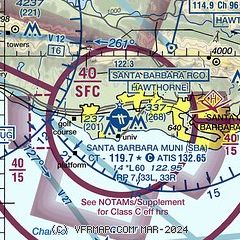
|
CAUTION: Diagram may not be current
 Download PDF
of official airport diagram from the FAA
| Airport distance calculator |
|---|
|
|
| Sunrise and sunset |
|---|
|
Times for 18-Apr-2026
| | Local
(UTC-7) | | Zulu
(UTC) |
|---|
| Morning civil twilight | | 05:59 | | 12:59 |
| Sunrise | | 06:25 | | 13:25 |
| Sunset | | 19:32 | | 02:32 |
| Evening civil twilight | | 19:58 | | 02:58 |
|
| Current date and time |
|---|
| Zulu (UTC) | 18-Apr-2026 15:37:01 |
|---|
| Local (UTC-7) | 18-Apr-2026 08:37:01 |
|---|
|
| METAR |
|---|
| KSBA | 181453Z 00000KT 10SM CLR 13/06 A2996 RMK AO2 SLP143 T01280056 53012 $
|
KIZA
15nm NW | 181515Z AUTO 00000KT 10SM CLR 09/06 A2998 RMK AO2
|
|
| TAF |
|---|
| KSBA | 181125Z 1812/1912 VRB03KT P6SM SKC FM181700 15006KT P6SM FEW250 FM182200 25008KT P6SM SKC FM190300 VRB03KT P6SM SKC
|
|
| NOTAMs |
|---|
NOTAMs are issued by the DoD/FAA and will open in a separate window not controlled by AirNav.
|
|


