FAA INFORMATION EFFECTIVE 17 APRIL 2025
Location
| FAA Identifier: | W22 |
| Lat/Long: | 39-00-02.1000N 080-16-29.8000W
39-00.035000N 080-16.496667W
39.0005833,-80.2749444
(estimated) |
| Elevation: | 1635.1 ft. / 498.4 m (surveyed) |
| Variation: | 08W (2005) |
| From city: | 2 miles W of BUCKHANNON, WV |
| Time zone: | UTC -4 (UTC -5 during Standard Time) |
| Zip code: | 26201 |
Airport Operations
| Airport use: | Open to the public |
| Activation date: | 05/1998 |
| Control tower: | no |
| ARTCC: | CLEVELAND CENTER |
| FSS: | ELKINS FLIGHT SERVICE STATION [703-724-4288] |
| NOTAMs facility: | EKN (NOTAM-D service available) |
| Attendance: | MON-FRI 0700-1700, ALL SAT 0700-1200
UNATNDD MAJ HOL, AFTR HRS ATNDT ON CALL 304-516-1920. |
| Wind indicator: | lighted |
| Segmented circle: | yes |
| Lights: | ACTVT PAPI RWY 29; MIRL RWY 11/29 - CTAF. |
| Beacon: | white-green (lighted land airport)
Operates sunset to sunrise. |
Airport Communications
| CTAF/UNICOM: | 122.8 |
| WX AWOS-3: | 119.975 (304-472-9428) |
| CLARKSBURG APPROACH: | 121.15 |
| CLARKSBURG DEPARTURE: | 121.15 |
| WX ASOS at CKB (18 nm N): | PHONE 304-842-9240 |
- APCH/DEP SVC PRVDD BY WASHINGTON ARTCC ON FREQS 128.6/226.675 (ELKINS RCAG) WHEN CLARKSBURG APCH CTL CLSD.
Nearby radio navigation aids
| VOR radial/distance | | VOR name | | Freq | | Var |
|---|
| EKNr309/9.7 | | ELKINS VORTAC | | 114.20 | | 07W |
| CKBr185/15.2 | | CLARKSBURG VOR/DME | | 112.60 | | 04W |
| MGWr215/38.5 | | MORGANTOWN VOR/DME | | 111.60 | | 05W |
| NDB name | | Hdg/Dist | | Freq | | Var | | ID |
|---|
| RANDOLPH COUNTY | | 295/20.4 | | 284 | | 07W | | RQY | .-. --.- -.-- |
Airport Services
| Fuel available: | 100LL JET-A
100LL:100LL 24 HR SELF SVC. FULL SVC DRG ATND HRS. AFTR HRS ON CALL.
A:JET A 24 HR SELF SVC. FULL SVC DRG ATND HRS. AFTR HRS ON CALL. |
| Parking: | tiedowns |
| Airframe service: | NONE |
| Powerplant service: | NONE |
| Bottled oxygen: | NONE |
| Bulk oxygen: | NONE |
Runway Information
Runway 11/29
| Dimensions: | 4201 x 75 ft. / 1280 x 23 m |
| Surface: | asphalt, in good condition |
| Weight bearing capacity: | | Single wheel: | 12.5 | | Double wheel: | 30.0 |
|
| Runway edge lights: | medium intensity |
| RUNWAY 11 | | RUNWAY 29 |
| Latitude: | 39-00.085258N | | 38-59.986192N |
| Longitude: | 080-16.935855W | | 080-16.058335W |
| Elevation: | 1631.4 ft. | | 1634.8 ft. |
| Traffic pattern: | left | | left |
| Runway heading: | 106 magnetic, 098 true | | 286 magnetic, 278 true |
| Markings: | nonprecision, in good condition | | nonprecision, in good condition |
| Visual slope indicator: | | | 2-light PAPI on left (3.00 degrees glide path)
VGSI AND GLIDEPATH NOT COINCIDENT. |
| Runway end identifier lights: | | | no |
| Touchdown point: | yes, no lights | | yes, no lights |
| Obstructions: | 42 ft. trees, 1175 ft. from runway, 175 ft. left of centerline, 23:1 slope to clear | | 20 ft. trees, 311 ft. from runway, 138 ft. left of centerline, 5:1 slope to clear
20 FT TREES, 311 FT DSTC, 138 FT L. |
Airport Ownership and Management from official FAA records
| Ownership: | Publicly-owned |
| Owner: | BUCKHANNON-UPSHUR ARPT AUTH
P. O. BOX 1042, BOX 1042
BUCKHANNON, WV 26201
Phone 412-812-2757
ARPT AUTHORITY PRESIDENT, MIKE RUFFING. |
| Manager: | JENNIFER L. POWERS
P. O. BOX 1042, BOX 1042
BUCKHANNON, WV 26201
Phone 304-472-9437
AFTR HRS AMGR CELL 304-516-1920 OR 304-613-7989. |
Additional Remarks
| - | DEER ON & INVOF ARPT. |
| - | FOR CD CTC CLARKSBURG APCH AT 304-842-2011, WHEN APCH CLSD CTC WASHINGTON CENTER AT 703-771-3479. |
Instrument Procedures
NOTE: All procedures below are presented as PDF files. If you need a reader for these files, you should download the free Adobe Reader.NOT FOR NAVIGATION. Please procure official charts for flight.
FAA instrument procedures published for use from 17 April 2025 at 0901Z to 15 May 2025 at 0900z.
IAPs - Instrument Approach Procedures |
|---|
| RNAV (GPS) RWY 11 | |
download (206KB) |
| RNAV (GPS) RWY 29 | |
download (234KB) |
| NOTE: Special Alternate Minimums apply | |
download (145KB) |
| NOTE: Special Take-Off Minimums/Departure Procedures apply | |
download (149KB) |
Other nearby airports with instrument procedures:
79D - Philippi/Barbour County Regional Airport (14 nm NE)
KCKB - North Central West Virginia Airport (18 nm N)
KEKN - Elkins-Randolph County Airport-Jennings Randolph Field (21 nm E)
48I - Braxton County Airport (26 nm SW)
4G7 - Fairmont Municipal Airport-Frankman Field (27 nm N)
|
|

Road maps at:
MapQuest
Bing
Google
| Aerial photo |
|---|
WARNING: Photo may not be current or correct
 Photo courtesy of Landmark Forestry, LLC (Mountain Air Services, LLC)
Photo taken 22-Jun-2006
Photo courtesy of Landmark Forestry, LLC (Mountain Air Services, LLC)
Photo taken 22-Jun-2006
Do you have a better or more recent aerial photo of Upshur County Regional Airport that you would like to share? If so, please send us your photo.
|
| Sectional chart |
|---|
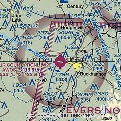
|
| Airport distance calculator |
|---|
|
|
| Sunrise and sunset |
|---|
|
Times for 01-May-2025
| | Local
(UTC-4) | | Zulu
(UTC) |
|---|
| Morning civil twilight | | 05:55 | | 09:55 |
| Sunrise | | 06:24 | | 10:24 |
| Sunset | | 20:12 | | 00:12 |
| Evening civil twilight | | 20:41 | | 00:41 |
|
| Current date and time |
|---|
| Zulu (UTC) | 02-May-2025 00:54:00 |
|---|
| Local (UTC-4) | 01-May-2025 20:54:00 |
|---|
|
| METAR |
|---|
| KW22 | 020035Z AUTO 23008G15KT 10SM FEW065 SCT100 BKN120 26/14 A2989 RMK AO2
|
KCKB
18nm N | 012353Z 23010G19KT 10SM CLR 26/12 A2984 RMK AO2 SLP090 60000 T02560122 10278 20239 55000
|
|
| TAF |
|---|
KCKB
18nm N | 012145Z 0122/0218 19007G17KT P6SM VCSH SCT070 BKN110 TEMPO 0122/0123 5SM -SHRA FM020100 21006KT 6SM -SHRA VCTS BKN060CB FM020400 20006KT P6SM -SHRA BKN030 FM020600 21006KT P6SM BKN050
|
KEKN
21nm E | 011840Z 0119/0218 21006KT P6SM VCTS SCT050CB BKN100 TEMPO 0119/0120 3SM TSRA BKN050CB FM012000 21006KT P6SM VCSH BKN050 FM020000 19004KT 6SM -SHRA VCTS SCT040CB OVC060 FM020500 20004KT P6SM -SHRA BKN040 FM020900 21005KT P6SM BKN030
|
|
| NOTAMs |
|---|
NOTAMs are issued by the DoD/FAA and will open in a separate window not controlled by AirNav.
|
|


