FAA INFORMATION EFFECTIVE 30 OCTOBER 2025
Location
| FAA Identifier: | Y70 |
| Lat/Long: | 42-56-16.5403N 085-03-38.0629W
42-56.275672N 085-03.634382W
42.9379279,-85.0605730
(estimated) |
| Elevation: | 817.8 ft. / 249.3 m (surveyed) |
| Variation: | 05W (2000) |
| From city: | 3 miles S of IONIA, MI |
| Time zone: | UTC -5 (UTC -4 during Daylight Saving Time) |
| Zip code: | 48846 |
Airport Operations
| Airport use: | Open to the public |
| Activation date: | 04/1940 |
| Control tower: | no |
| ARTCC: | CHICAGO CENTER |
| FSS: | LANSING FLIGHT SERVICE STATION |
| NOTAMs facility: | Y70 (NOTAM-D service available) |
| Attendance: | 0700-1500
UNATNDD MAJOR HOLS. |
| Wind indicator: | lighted |
| Segmented circle: | yes |
| Lights: | ACTVT REIL RWY 28; PAPI RWY 10 & 28; MIRL RWY 10/28 - CTAF. |
| Beacon: | white-green (lighted land airport)
Operates sunset to sunrise. |
Airport Communications
| CTAF/UNICOM: | 122.8 |
| WX AWOS-3: | 118.9 (616-523-1852) |
| GREAT LAKES APPROACH: | 118.65 |
| GREAT LAKES DEPARTURE: | 118.65 |
- APCH/DEP SVC PRVDD BY CHICAGO ARTCC (ZAU) ON FREQS 128.4 (GRAND RAPIDS RCAG) WHEN GREAT LAKES APCH CTL CLSD.
Nearby radio navigation aids
| VOR radial/distance | | VOR name | | Freq | | Var |
|---|
| VIOr069/21.2 | | VICTORY VOR/DME | | 115.95 | | 04W |
| NDB name | | Hdg/Dist | | Freq | | Var | | ID |
|---|
| KNOBS | | 086/14.2 | | 263 | | 06W | | GR | --. .-. |
Airport Services
| Fuel available: | 100LL |
| Parking: | hangars and tiedowns |
| Airframe service: | MAJOR |
| Powerplant service: | MAJOR |
| Bottled oxygen: | HIGH/LOW |
| Bulk oxygen: | NONE |
Runway Information
Runway 10/28
| Dimensions: | 4298 x 75 ft. / 1310 x 23 m |
| Surface: | asphalt, in fair condition |
| Weight bearing capacity: | |
| Runway edge lights: | medium intensity |
| RUNWAY 10 | | RUNWAY 28 |
| Latitude: | 42-56.276868N | | 42-56.269148N |
| Longitude: | 085-04.264662W | | 085-03.301688W |
| Elevation: | 813.8 ft. | | 802.4 ft. |
| Traffic pattern: | left | | left |
| Runway heading: | 096 magnetic, 091 true | | 276 magnetic, 271 true |
| Markings: | nonprecision, in good condition | | nonprecision, in good condition |
| Visual slope indicator: | 4-light PAPI on left (3.00 degrees glide path) | | 4-light PAPI on left (3.00 degrees glide path) |
| Runway end identifier lights: | no | | yes |
| Touchdown point: | yes, no lights | | yes, no lights |
Runway 18/36
| Dimensions: | 4261 x 340 ft. / 1299 x 104 m |
| Surface: | turf, in fair condition |
| Runway edge markings: | 3 FT YELLOW CONES. |
| Operational restrictions: | RWY 18/36 MKD WITH 3 FT YELLOW CONES. |
| RUNWAY 18 | | RUNWAY 36 |
| Latitude: | 42-56.629043N | | 42-55.927672N |
| Longitude: | 085-03.484297W | | 085-03.484297W |
| Elevation: | 803.5 ft. | | 817.6 ft. |
| Traffic pattern: | left | | left |
| Runway heading: | 185 magnetic, 180 true | | 005 magnetic, 000 true |
| Touchdown point: | yes, no lights | | yes, no lights |
| Obstructions: | 82 ft. tree, 1242 ft. from runway, 225 ft. left of centerline, 15:1 slope to clear | | 73 ft. tree, 986 ft. from runway, 220 ft. right of centerline, 13:1 slope to clear
ALSO +33 FT PLINE, 1015 FT DIST, 30:1. |
Airport Ownership and Management from official FAA records
| Ownership: | Publicly-owned |
| Owner: | IONIA COUNTY
COURT HOUSE, 100 W MAIN ST
IONIA, MI 48846-1651
Phone 616-527-5300 |
| Manager: | MATT KUHNS
468 E SPRAGUE RD
IONIA, MI 48846
Phone 616-902-2281 |
Additional Remarks
| A52-10 | ALSO +25 FT PLINE, 1154 FT DIST, 38:1. |
| - | EXTENSIVE SOARING ACTIVITY. |
| - | GLDR OPS CONDUCTED S OF RWY 10/28 & WEST OF RWY 18/36; USE FREQ 123.3 IN PRACTICE AREA. GLDRS USE CTAF IN TFC PAT. |
| - | TREES OBST VIEW BTWN RWY END 18 WITH RWY END 10 & 28. |
| - | HOSPITAL & HOSPITAL HELI ADJ SOUTH OF RWY 10/28. |
| - | FOR CD CTC GREAT LAKES APCH AT 269-459-3345, WHEN APCH CLSD CTC CHICAGO ARTCC AT 630-906-8921. |
Instrument Procedures
NOTE: All procedures below are presented as PDF files. If you need a reader for these files, you should download the free Adobe Reader.NOT FOR NAVIGATION. Please procure official charts for flight.
FAA instrument procedures published for use from 30 October 2025 at 0901Z to 27 November 2025 at 0900Z.
IAPs - Instrument Approach Procedures |
|---|
| RNAV (GPS) RWY 10 | |
download (230KB) |
| RNAV (GPS) RWY 28 | |
download (185KB) |
| NOTE: Special Alternate Minimums apply | |
download (134KB) |
| NOTE: Special Take-Off Minimums/Departure Procedures apply | |
download (346KB) |
Other nearby airports with instrument procedures:
6D6 - Greenville Municipal Airport (15 nm NW)
4D0 - Abrams Municipal Airport (17 nm SE)
KGRR - Gerald R Ford International Airport (21 nm W)
9D9 - Hastings Airport (21 nm SW)
KLAN - Capital Region International Airport (23 nm SE)
|
|

Road maps at:
MapQuest
Bing
Google
| Aerial photo |
|---|
WARNING: Photo may not be current or correct
 Photo by Tal Reichert
Photo taken 29-Jul-2012
looking north.
Photo by Tal Reichert
Photo taken 29-Jul-2012
looking north.
Do you have a better or more recent aerial photo of Ionia County Airport that you would like to share? If so, please send us your photo.
|
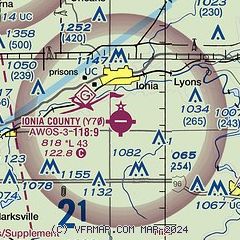
| Sectional chart |
|---|
|
| Airport distance calculator |
|---|
|
|
| Sunrise and sunset |
|---|
|
Times for 06-Nov-2025
| | Local
(UTC-5) | | Zulu
(UTC) |
|---|
| Morning civil twilight | | 06:52 | | 11:52 |
| Sunrise | | 07:22 | | 12:22 |
| Sunset | | 17:26 | | 22:26 |
| Evening civil twilight | | 17:56 | | 22:56 |
|
| Current date and time |
|---|
| Zulu (UTC) | 06-Nov-2025 17:30:08 |
|---|
| Local (UTC-5) | 06-Nov-2025 12:30:08 |
|---|
|
| METAR |
|---|
| KY70 | 061715Z AUTO 22008KT 10SM CLR 09/M01 A3020 RMK AO2
|
|
| TAF |
|---|
KGRR
20nm W | 061139Z 0612/0712 18004KT P6SM SKC FM061800 22008KT P6SM BKN250 FM070200 17008KT P6SM BKN120 FM070600 18012G25KT P6SM -SHRA OVC110 FM070900 21012G26KT 6SM -SHRA OVC035
|
KLAN
23nm SE | 061139Z 0612/0712 VRB03KT P6SM SKC FM061600 23007KT P6SM BKN250 FM062300 17007KT P6SM BKN200 FM070500 18011G23KT P6SM OVC140 FM070900 19015G28KT 6SM -SHRA OVC090 FM071100 21013G26KT 6SM -SHRA OVC035
|
|
| NOTAMs |
|---|
NOTAMs are issued by the DoD/FAA and will open in a separate window not controlled by AirNav.
|
|

