FAA INFORMATION EFFECTIVE 14 MAY 2026
Location
| FAA Identifier: | 4N1 |
| Lat/Long: | 41-07-42.2000N 074-20-47.5000W
41-07.703333N 074-20.791667W
41.1283889,-74.3465278
(estimated) |
| Elevation: | 789.6 ft. / 240.7 m (surveyed) |
| Variation: | 13W (1995) |
| From city: | 1 mile E of WEST MILFORD, NJ |
| Time zone: | UTC -4 (UTC -5 during Standard Time) |
| Zip code: | 07480 |
Airport Operations
| Airport use: | Open to the public |
| Activation date: | 06/1960 |
| Control tower: | no |
| ARTCC: | NEW YORK CENTER |
| FSS: | MILLVILLE FLIGHT SERVICE STATION |
| NOTAMs facility: | MIV (NOTAM-D service available) |
| Attendance: | 0800-1700 |
| Wind indicator: | lighted |
| Segmented circle: | no |
| Lights: | ACTVT MIRL RWY 06/24 - CTAF, 5 CLICKS. PAPI RWY 24 OPR CONSLY. |
| Beacon: | white-green (lighted land airport)
Operates sunset to sunrise. |
Airport Communications
| CTAF: | 122.9 |
| NEWARK APPROACH: | 127.6 |
| NEWARK DEPARTURE: | 127.6 |
| WX ASOS at FWN (13 nm W): | 118.525 (973-970-3780) |
| WX ASOS at CDW (15 nm S): | 135.5 (631-594-4523) |
| WX ASOS at 12N (19 nm W): | PHONE 609-325-2295 |
| WX AWOS-3 at MMU (20 nm S): | PHONE 973-290-0135 |
Nearby radio navigation aids
| VOR radial/distance | | VOR name | | Freq | | Var |
|---|
| SAXr078/9.4 | | SPARTA VORTAC | | 115.70 | | 11W |
| HUOr158/20.2 | | HUGUENOT VOR/DME | | 116.10 | | 11W |
| TEBr334/21.2 | | TETERBORO VOR/DME | | 108.40 | | 11W |
| STWr082/24.9 | | STILLWATER VOR/DME | | 109.60 | | 11W |
| BWZr058/29.3 | | BROADWAY VOR/DME | | 114.20 | | 11W |
| LGAr326/29.9 | | LA GUARDIA VOR/DME | | 113.10 | | 12W |
| CMKr267/35.7 | | CARMEL VOR/DME | | 116.60 | | 12W |
| CRIr337/37.1 | | CANARSIE VOR/DME | | 112.30 | | 11W |
| SBJr039/37.3 | | SOLBERG VOR/DME | | 112.90 | | 10W |
| JFKr331/39.6 | | KENNEDY VOR/DME | | 115.90 | | 12W |
| IGNr228/39.9 | | KINGSTON VOR/DME | | 117.60 | | 12W |
| NDB name | | Hdg/Dist | | Freq | | Var | | ID |
|---|
| STANWYCK | | 222/27.6 | | 261 | | 12W | | SKU | ... -.- ..- |
Airport Services
| Fuel available: | 100LL JET-A |
| Oil available: | AUTOMATED UNICOM; 3 CLICKS TO ACTVT. |
| Parking: | tiedowns |
| Airframe service: | MAJOR |
| Powerplant service: | MAJOR |
| Bottled oxygen: | NONE |
| Bulk oxygen: | NONE |
Runway Information
Runway 6/24
| Dimensions: | 3471 x 60 ft. / 1058 x 18 m |
| Surface: | asphalt, in excellent condition |
| Runway edge lights: | medium intensity |
| RUNWAY 6 | | RUNWAY 24 |
| Latitude: | 41-07.510958N | | 41-07.894688N |
| Longitude: | 074-21.072025W | | 074-20.511670W |
| Elevation: | 789.3 ft. | | 789.4 ft. |
| Traffic pattern: | right | | left |
| Runway heading: | 061 magnetic, 048 true | | 241 magnetic, 228 true |
| Markings: | nonprecision, in good condition | | nonprecision, in good condition |
| Visual slope indicator: | | | 2-light PAPI on left (3.50 degrees glide path) |
| Runway end identifier lights: | no | | no |
| Touchdown point: | yes, no lights | | yes, no lights |
| Obstructions: | 192 ft. trees, 1988 ft. from runway, 170 ft. right of centerline, 9:1 slope to clear
TREES BELOW RWY END, CLIFF. | | 23 ft. tree, 680 ft. from runway, 132 ft. left of centerline, 20:1 slope to clear |
Airport Ownership and Management from official FAA records
| Ownership: | Publicly-owned |
| Owner: | N.J. DEPT. TRANSPORTATION
1035 PARKWAY AVE. P.O. BOX 610
TRENTON, NJ 08625
Phone 609-963-2100 |
| Manager: | TIM WAGNER
126A AIRPORT RD BOX 1
WEST MILFORD, NJ 07480
Phone 973-728-7721 |
Additional Remarks
| - | RY 06/24 STEEP ROCK LEDGES LCTD JUST BYD BOTH RY ENDS. |
| - | ARPT SUBJECT TO GUSTING WIND & FREQUENT CROSSWINDS. |
| - | SOME RWY AND TWY LGTS TALLER THAN STANDARD. |
| - | DEER AND BIRDS ON AND INVOF ARPT. |
| - | FOR CD CTC NEWARK APCH AT 800-645-3206. |
| - | DROP ZONE LCTD SE SIDE OF RWY. |
Instrument Procedures
NOTE: All procedures below are presented as PDF files. If you need a reader for these files, you should download the free Adobe Reader.NOT FOR NAVIGATION. Please procure official charts for flight.
FAA instrument procedures published for use from 14 May 2026 at 0901Z to 11 June 2026 at 0900Z.
IAPs - Instrument Approach Procedures |
|---|
| RNAV (GPS) RWY 06 | |
download (195KB) |
| RNAV (GPS) RWY 24 | |
download (216KB) |
| NOTE: Special Take-Off Minimums/Departure Procedures apply | |
download (150KB) |
Other nearby airports with instrument procedures:
N07 - Lincoln Park Airport (11 nm S)
KFWN - Sussex Airport (13 nm W)
KCDW - Essex County Airport (15 nm S)
06N - Randall Airport (18 nm N)
12N - Aeroflex/Andover Airport (19 nm W)
KMMU - Morristown Municipal Airport (20 nm S)
|
|

Road maps at:
MapQuest
Bing
Google
| Aerial photo |
|---|
WARNING: Photo may not be current or correct
 Photo by Wendy Silcox McPherson
Photo taken 17-Nov-2012
looking south.
Photo by Wendy Silcox McPherson
Photo taken 17-Nov-2012
looking south.
Do you have a better or more recent aerial photo of Greenwood Lake Airport that you would like to share? If so, please send us your photo.
|
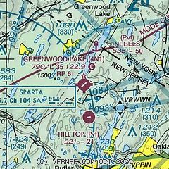
| Sectional chart |
|---|
|
| Airport distance calculator |
|---|
|
|
| Sunrise and sunset |
|---|
|
Times for 06-Jun-2026
| | Local
(UTC-4) | | Zulu
(UTC) |
|---|
| Morning civil twilight | | 04:53 | | 08:53 |
| Sunrise | | 05:26 | | 09:26 |
| Sunset | | 20:26 | | 00:26 |
| Evening civil twilight | | 20:59 | | 00:59 |
|
| Current date and time |
|---|
| Zulu (UTC) | 06-Jun-2026 12:54:09 |
|---|
| Local (UTC-4) | 06-Jun-2026 08:54:09 |
|---|
|
| METAR |
|---|
KFWN
14nm W | 061153Z AUTO 00000KT 10SM CLR 18/14 A2993 RMK AO2 SLP131 T01830139 10183 20139 50001 $
|
KCDW
15nm S | 061153Z 00000KT 10SM CLR 22/14 A2992 RMK AO2 SLP134 T02220144 10222 20167 51004
|
K12N
19nm W | 061154Z AUTO 00000KT 20/15 A2993 RMK AO1 SLP126 70009 T02000150 10200 20144 50002
|
KTEB
21nm SE | 061151Z 22005KT 10SM CLR 24/15 A2990 RMK AO2 SLP124 T02390150 10239 20194 50003 $
|
KMMU
21nm S | 061145Z 00000KT 10SM SCT120 21/17 A2992
|
KMGJ
24nm N | SuperAWOS
061154Z AUTO 00000KT 10SM SCT070 BKN100 BKN110 19/16 A2990 RMK AO2 SLP121 T01890156 10189 20139 50002
|
KSWF
25nm NE | 061145Z 00000KT 10SM BKN070 20/15 A2990
|
KNYC
27nm SE | 061151Z 00000KT 10SM CLR 24/15 A2993 RMK AO2 SLP126 T02440150 10250 20233 50003 $
|
|
| TAF |
|---|
KTEB
21nm SE | 061120Z 0612/0718 23004KT P6SM FEW250 FM061300 23008KT P6SM SCT250 FM061600 23012G20KT P6SM SCT100 BKN250 FM062200 25014G22KT P6SM SCT050 BKN200 PROB30 0700/0706 3SM TSRA BR SCT025 BKN050CB FM070600 26009KT P6SM FEW050 SCT080 FM071300 30011KT P6SM SKC
|
KSWF
25nm NE | 061120Z 0612/0718 VRB01KT P6SM SCT070 FM061300 24008KT P6SM SCT120 FM061600 25013G21KT P6SM SCT050 SCT100 PROB30 0622/0702 3SM TSRA SCT020 BKN040CB FM070300 26008KT P6SM VCSH BKN100 FM071200 28010KT P6SM SKC FM071600 30013KT P6SM SCT050 AMD NOT SKED
|
|
| NOTAMs |
|---|
NOTAMs are issued by the DoD/FAA and will open in a separate window not controlled by AirNav.
|
|

