FAA INFORMATION EFFECTIVE 09 JULY 2026
Location
| FAA Identifier: | 4V8 |
| Lat/Long: | 42-55-37.6880N 072-51-56.3530W
42-55.628133N 072-51.939217W
42.9271356,-72.8656536
(estimated) |
| Elevation: | 1953 ft. / 595.3 m (surveyed) |
| Variation: | 15W (1985) |
| From city: | 1 mile SW of WEST DOVER, VT |
| Time zone: | UTC -4 (UTC -5 during Standard Time) |
| Zip code: | 05356 |
Airport Operations
| Airport use: | Open to the public |
| Activation date: | 11/1982 |
| Control tower: | no |
| ARTCC: | BOSTON CENTER |
| FSS: | BURLINGTON FLIGHT SERVICE STATION |
| NOTAMs facility: | BTV (NOTAM-D service available) |
| Attendance: | UNATTND |
| Segmented circle: | no |
| Landing fee: | yes |
Airport Communications
| CTAF/UNICOM: | 122.8 |
| WX ASOS at DDH (17 nm W): | 135.925 (802-442-6059) |
| WX ASOS at AQW (19 nm SW): | 134.775 (413-664-6658) |
- APCH/DEP SVC PRVDD BY BOSTON ARTCC ON FREQS 123.75/338.2 (GARDNER RCAG).
Nearby radio navigation aids
| VOR radial/distance | | VOR name | | Freq | | Var |
|---|
| CAMr115/21.4 | | CAMBRIDGE VOR/DME | | 115.00 | | 14W |
| CTRr019/38.3 | | CHESTER VOR/DME | | 115.10 | | 13W |
| NDB name | | Hdg/Dist | | Freq | | Var | | ID |
|---|
| CLAREMONT | | 235/34.2 | | 233 | | 16W | | CNH | -.-. -. .... |
Airport Services
Runway Information
Runway 1/19
| Dimensions: | 2650 x 75 ft. / 808 x 23 m |
| Surface: | asphalt, in poor condition
DEBRIS ON RWY, EXTSV CRACKING.
DEBRIS ON RWY. EXTSV CRACKING. |
| Runway edge lights: | medium intensity |
| RUNWAY 1 | | RUNWAY 19 |
| Latitude: | 42-55.413750N | | 42-55.843583N |
| Longitude: | 072-51.887917W | | 072-51.989667W |
| Elevation: | 1948.0 ft. | | 1950.0 ft. |
| Traffic pattern: | left | | left |
| Runway heading: | 005 magnetic, 350 true | | 185 magnetic, 170 true |
| Markings: | nonprecision | | basic |
| Touchdown point: | yes, no lights | | no, no lights |
| Obstructions: | 6130 ft. trees, 201 ft. from runway, 103 ft. left of centerline
CTLG OBSTN EXCEEDS 45 DEG SLP. | | 50 ft. trees, 201 ft. from runway, 95 ft. left and right of centerline
18 FT TREE, 66 FT, 35 FT L. |
Airport Ownership and Management from official FAA records
| Ownership: | Privately-owned |
| Owner: | A W REALTY, LLC
, P.O. BOX 1
MANCHESTER CENTER, VT 05255
Phone 281-788-8450 |
| Manager: | ALLISON KIMBALL
, P.O. BOX 1
MANCHESTER CENTER, VT 05255
Phone 281-788-8450
LCL CTC LYNN BUCOSSI 802-681-3434. |
Additional Remarks
| - | 60 FT DROP OFF, 60 FT FM RWY END. |
| - | RWY 19: -60 FT DROP OFF, 60 FT FM RWY END. |
| - | FOR CD CTC BOSTON ARTCC AT 603-879-6859. |
| - | NO LN OF SIGHT BTN RWY ENDS. |
Instrument Procedures
There are no published instrument procedures at 4V8.
Some nearby airports with instrument procedures:
KDDH - William H Morse State Airport (17 nm W)
KAQW - Harriman-and-West Airport (19 nm SW)
0B5 - Turners Falls Airport (25 nm SE)
KEEN - Dillant/Hopkins Airport (26 nm E)
KVSF - Hartness State Airport (Springfield) (29 nm NE)
|
|

Road maps at:
MapQuest
Bing
Google
| Aerial photo |
|---|
WARNING: Photo may not be current or correct
 Photo by Guy Rouelle
Photo taken 23-May-2015
looking north.
Photo by Guy Rouelle
Photo taken 23-May-2015
looking north.
Do you have a better or more recent aerial photo of Deerfield Valley Regional Airport that you would like to share? If so, please send us your photo.
|
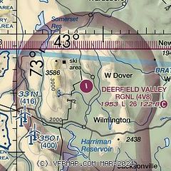
| Sectional chart |
|---|
|
| Airport distance calculator |
|---|
|
|
| Sunrise and sunset |
|---|
|
Times for 10-Jul-2026
| | Local
(UTC-4) | | Zulu
(UTC) |
|---|
| Morning civil twilight | | 04:49 | | 08:49 |
| Sunrise | | 05:23 | | 09:23 |
| Sunset | | 20:30 | | 00:30 |
| Evening civil twilight | | 21:05 | | 01:05 |
|
| Current date and time |
|---|
| Zulu (UTC) | 10-Jul-2026 17:19:27 |
|---|
| Local (UTC-4) | 10-Jul-2026 13:19:27 |
|---|
|
| METAR |
|---|
KDDH
17nm W | 101654Z AUTO 36009G16KT 10SM FEW030 SCT036 BKN047 24/18 A2986 RMK AO2 SLP105 T02390178
|
KAQW
19nm SW | 101652Z AUTO 23006KT 10SM SCT085 26/18 A2984 RMK AO2 SLP100 T02610183
|
KEEN
26nm E | 101656Z AUTO 28008KT 10SM FEW038 SCT048 BKN075 26/20 A2981 RMK AO2 SLP093 T02560200 PNO $
|
KVSF
30nm NE | 101654Z AUTO VRB05KT 10SM FEW055 BKN070 27/15 A2983 RMK AO2 SLP098 T02670150
|
KORE
34nm SE | 101652Z AUTO 30009KT 10SM SCT040 BKN047 BKN055 28/18 A2981 RMK AO2 SLP092 T02830178
|
|
| TAF |
|---|
KPSF
35nm SW | 101120Z 1012/1112 30007KT P6SM SCT015 BKN100 FM101800 30008G15KT P6SM SCT050 BKN250 FM110100 VRB03KT P6SM SCT250
|
KRUT
36nm N | 101120Z 1012/1112 32004KT P6SM BKN023 OVC050 PROB30 1012/1013 5SM -SHRA BR OVC013 FM101400 33008KT P6SM SCT060 FM102300 VRB03KT P6SM SKC FM110200 13004KT P6SM SKC
|
KGFL
41nm NW | 101120Z 1012/1112 34006G12KT P6SM SCT050 BKN250 FM101700 02007G15KT P6SM BKN040 BKN250 FM102200 36008G12KT P6SM BKN250 FM110100 VRB02KT P6SM FEW050 SCT250
|
KALB
42nm W | 101120Z 1012/1112 29011KT P6SM SCT090 SCT250 FM101500 31007KT P6SM BKN050 BKN250 FM102300 03006KT P6SM SCT250
|
|
| NOTAMs |
|---|
NOTAMs are issued by the DoD/FAA and will open in a separate window not controlled by AirNav.
|
|

