FAA INFORMATION EFFECTIVE 18 APRIL 2024
Location
| FAA Identifier: | 89D |
| Lat/Long: | 41-36-11.4550N 082-41-06.1950W
41-36.190917N 082-41.103250W
41.6031819,-82.6850542
(estimated) |
| Elevation: | 598.2 ft. / 182.3 m (surveyed) |
| Variation: | 07W (2000) |
| From city: | 1 mile NE of KELLEYS ISLAND, OH |
| Time zone: | UTC -4 (UTC -5 during Standard Time) |
| Zip code: | 43438 |
Airport Operations
| Airport use: | Open to the public |
| Activation date: | 05/1949 |
| Control tower: | no |
| ARTCC: | CLEVELAND CENTER |
| FSS: | CLEVELAND FLIGHT SERVICE STATION |
| NOTAMs facility: | CLE (NOTAM-D service available) |
| Attendance: | UNATNDD |
| Wind indicator: | lighted |
| Segmented circle: | no |
| Lights: | SS-SR |
| Landing fee: | yes |
Airport Communications
| CTAF: | 122.9 |
| WX AWOS-3 at PCW (10 nm SW): | 118.775 (419-734-9955) |
Nearby radio navigation aids
| VOR radial/distance | | VOR name | | Freq | | Var |
|---|
| DJBr307/27.7 | | DRYER VOR/DME | | 113.60 | | 05W |
| NDB name | | Hdg/Dist | | Freq | | Var | | ID |
|---|
| PORT CLINTON | | 065/9.7 | | 423 | | 07W | | PCW | .--. -.-. .-- |
| GROSSE ILE | | 152/36.5 | | 419 | | 07W | | RYS | .-. -.-- ... |
| TIFFIN | | 043/38.7 | | 269 | | 05W | | TII | - .. .. |
Airport Services
| Parking: | tiedowns |
| Airframe service: | NONE |
| Powerplant service: | NONE |
| Bottled oxygen: | NONE |
| Bulk oxygen: | NONE |
Runway Information
Runway 9/27
| Dimensions: | 2202 x 50 ft. / 671 x 15 m |
| Surface: | asphalt, in good condition |
| Runway edge lights: | low intensity |
| RUNWAY 9 | | RUNWAY 27 |
| Latitude: | 41-36.198333N | | 41-36.183500N |
| Longitude: | 082-41.344500W | | 082-40.862000W |
| Elevation: | 598.2 ft. | | 578.9 ft. |
| Traffic pattern: | left | | left |
| Runway heading: | 099 magnetic, 092 true | | 279 magnetic, 272 true |
| Displaced threshold: | 200 ft. | | no |
| Markings: | basic, in fair condition | | basic, in fair condition |
| Runway end identifier lights: | no | | no |
| Touchdown point: | yes, no lights | | yes, no lights |
| Obstructions: | 54 ft. trees, 394 ft. from runway, 139 ft. right of centerline, 3:1 slope to clear
10 FT ROAD, 12 FT DIST, 125 FT L/R. | | 3 ft. fence, 201 ft. from runway, 100 ft. left of centerline
+10 FT ROAD, 0-92 FT DIST, 0-125 FT L; +4 FT PROPANE TANK, 104-120 FT DIST, 87-92 FT L; +18 FT HOUSE, 102-200 FT DIST, 94-125 FT L; +12 FT TREES, 106-136 FT DIST, 80 FT L. |
Airport Ownership and Management from official FAA records
| Ownership: | Publicly-owned |
| Owner: | VILLAGE OF KELLEYS ISLAND
121 ADDISON ST BOX 469
KELLEYS ISLAND, OH 43438
Phone 419-746-2535
UNMON ARPT TRML 419-746-2228. |
| Manager: | ROBERT QUINN
121 ADDISON ST BOX 469
KELLEYS ISLAND, OH 43438
Phone 419-503-0663 |
Airport Operational Statistics
| Aircraft based on the field: | | 2 | | Single engine airplanes: | | 2 |
| |  | |
| Aircraft operations: avg 70/day * | | 37% | transient general aviation | | 34% | air taxi | | 29% | local general aviation | | * for 12-month period ending 27 September 2021 | |
Additional Remarks
| - | DEER ON & INVOF ARPT. |
| - | FOR CD CTC CLEVELAND APCH AT 216-352-2323. |
Instrument Procedures
There are no published instrument procedures at 89D.
Some nearby airports with instrument procedures:
KPCW - Erie-Ottawa International Airport (10 nm SW)
5A1 - Norwalk-Huron County Airport (22 nm S)
S24 - Sandusky County Regional Airport (24 nm SW)
14G - Fremont Airport (27 nm SW)
KLPR - Lorain County Regional Airport (28 nm SE)
|
|

Road maps at:
MapQuest
Bing
Google
| Aerial photo |
|---|
WARNING: Photo may not be current or correct
 Photo by David Newcomer
Photo taken 22-Sep-2017
from 2,000' AGL looking west.
Photo by David Newcomer
Photo taken 22-Sep-2017
from 2,000' AGL looking west.
Do you have a better or more recent aerial photo of Kelleys Island Land Field Airport that you would like to share? If so, please send us your photo.
|
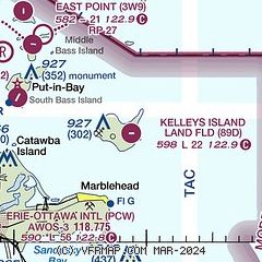
| Sectional chart |
|---|
|
| Airport distance calculator |
|---|
|
|
| Sunrise and sunset |
|---|
|
Times for 24-Apr-2024
| | Local
(UTC-4) | | Zulu
(UTC) |
|---|
| Morning civil twilight | | 06:07 | | 10:07 |
| Sunrise | | 06:37 | | 10:37 |
| Sunset | | 20:21 | | 00:21 |
| Evening civil twilight | | 20:50 | | 00:50 |
|
| Current date and time |
|---|
| Zulu (UTC) | 24-Apr-2024 16:14:00 |
|---|
| Local (UTC-4) | 24-Apr-2024 12:14:00 |
|---|
|
| METAR |
|---|
KPCW
10nm SW | 241555Z AUTO 03012G17KT 10SM SCT020 OVC027 07/03 A3014 RMK AO2
|
|
| TAF |
|---|
KCLE
39nm E | 241319Z 2413/2518 34014G22KT P6SM OVC015 TEMPO 2413/2415 BKN008 FM242200 35010KT P6SM BKN025 FM250200 01007KT P6SM SCT030
|
CYQG
42nm N | 241140Z 2412/2512 35013G23KT P6SM OVC015 TEMPO 2412/2414 BKN008 OVC015 FM241400 36015G25KT P6SM OVC020 TEMPO 2414/2416 BKN030 FM241600 36012G22KT P6SM BKN040 FM242000 36012KT P6SM FEW050 FM250500 35005KT P6SM SKC RMK FCST BASED ON AUTO OBS. NXT FCST BY 241800Z
|
KDTW
48nm NW | 241120Z 2412/2518 36015G22KT P6SM OVC016 FM241600 36012KT P6SM BKN024 FM242000 01010KT P6SM SKC FM250100 02005KT P6SM SKC FM251000 02003KT P6SM SKC
|
KMFD
48nm S | 241121Z 2412/2512 28010KT P6SM BKN020 FM241400 33010KT P6SM OVC008 FM241700 35011KT P6SM OVC015 FM250000 36007KT P6SM BKN020 FM250200 01004KT P6SM SCT030
|
|
| NOTAMs |
|---|
NOTAMs are issued by the DoD/FAA and will open in a separate window not controlled by AirNav.
|
|

