FAA INFORMATION EFFECTIVE 27 NOVEMBER 2025
Location
| FAA Identifier: | F72 |
| Lat/Long: | 38-18-14.4000N 121-25-45.5000W
38-18.240000N 121-25.758333W
38.3040000,-121.4293056
(estimated) |
| Elevation: | 23.1 ft. / 7.0 m (surveyed) |
| Variation: | 16E (1985) |
| From city: | 4 miles SE of FRANKLIN, CA |
| Time zone: | UTC -8 (UTC -7 during Daylight Saving Time) |
| Zip code: | 95758 |
Airport Operations
| Airport use: | Open to the public |
| Activation date: | 07/1946 |
| Control tower: | no |
| ARTCC: | OAKLAND CENTER |
| FSS: | RANCHO MURIETA FLIGHT SERVICE STATION |
| NOTAMs facility: | RIU (NOTAM-D service available) |
| Attendance: | UNATNDD |
| Wind indicator: | yes |
| Segmented circle: | yes |
Airport Communications
| CTAF: | 122.9 |
| WX ASOS at SAC (13 nm N): | PHONE 916-421-0923 |
| WX AWOS-AV at O88 (15 nm SW): | 127.075 (707-374-5396) |
| WX AWOS-3PT at MHR (16 nm N): | 118.325 (916-366-3371) |
Nearby radio navigation aids
| VOR radial/distance | | VOR name | | Freq | | Var |
|---|
| SACr129/10.2 | | SACRAMENTO VORTAC | | 115.20 | | 17E |
| MCCr166/21.8 | | MC CLELLAN VOR/DME | | 109.20 | | 17E |
| LINr287/24.3 | | LINDEN VOR/DME | | 114.80 | | 17E |
| CCRr045/32.9 | | CONCORD VOR/DME | | 117.00 | | 17E |
Airport Services
| Parking: | tiedowns |
| Airframe service: | NONE |
| Powerplant service: | NONE |
| Bottled oxygen: | NONE |
| Bulk oxygen: | NONE |
Runway Information
Runway 18/36
| Dimensions: | 3123 x 60 ft. / 952 x 18 m |
| Surface: | asphalt, in good condition |
| Weight bearing capacity: | |
| RUNWAY 18 | | RUNWAY 36 |
| Latitude: | 38-18.629595N | | 38-18.130757N |
| Longitude: | 121-25.668482W | | 121-25.828122W |
| Elevation: | 22.8 ft. | | 20.6 ft. |
| Traffic pattern: | left | | right |
| Runway heading: | 178 magnetic, 194 true | | 358 magnetic, 014 true |
| Markings: | basic, in good condition | | basic, in good condition |
| Touchdown point: | yes, no lights | | yes, no lights |
Runway 9/27
| Dimensions: | 3031 x 60 ft. / 924 x 18 m |
| Surface: | asphalt, in good condition |
| Weight bearing capacity: | |
| RUNWAY 9 | | RUNWAY 27 |
| Latitude: | 38-18.157475N | | 38-18.034537N |
| Longitude: | 121-26.075107W | | 121-25.461010W |
| Elevation: | 19.3 ft. | | 21.8 ft. |
| Traffic pattern: | right | | left |
| Runway heading: | 088 magnetic, 104 true | | 268 magnetic, 284 true |
| Markings: | basic, in good condition | | basic, in good condition |
| Runway end identifier lights: | | | no |
| Touchdown point: | yes, no lights | | yes, no lights |
Airport Ownership and Management from official FAA records
| Ownership: | Publicly-owned |
| Owner: | SACRAMENTO COUNTY
6151 FREEPORT BLVD
SACRAMENTO, CA 95822-3518
Phone 916-875-9035 |
| Manager: | RON OGLE
5999 FREEPORT BLVD
SACRAMENTO, CA 95822-3518
Phone 916-875-6852
SACRAMENTO EXECUTIVE AIRPORT. |
Additional Remarks
| - | ALL RYS LTD TO 12,500 LBS GWT. |
| - | TWY B CLSD PERMLY. |
| - | MONITOR 122.9 WITHIN 5 MILES. EXTSV STUDENT TRAINING IN AREA. |
| - | CALM WIND RY 18. |
| - | AVOID OVERFLIGHT OF DETENTION FACILITY ON EAST SIDE OF ARPT EXCP IN EMERGENCY. |
| - | CONDUCT HELICOPTER TRAINING N OF RY 09 & W OF RY 36. |
| - | ULTRALIGHTS ACTIVITY INVOF ARPT. |
| - | FOR CD CTC NORCAL APCH AT 916-361-6874. |
Instrument Procedures
There are no published instrument procedures at F72.
Some nearby airports with instrument procedures:
1O3 - Lodi Airport (10 nm SE)
KSAC - Sacramento Executive Airport (13 nm N)
O88 - Rio Vista Municipal Airport (15 nm SW)
KMHR - Sacramento Mather Airport (16 nm N)
KEDU - University Airport (22 nm NW)
|
|

Road maps at:
MapQuest
Bing
Google
| Aerial photo |
|---|
WARNING: Photo may not be current or correct

Do you have a better or more recent aerial photo of Franklin Field Airport that you would like to share? If so, please send us your photo.
|
| Sectional chart |
|---|
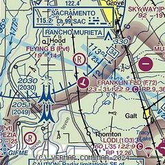
|
| Airport distance calculator |
|---|
|
|
| Sunrise and sunset |
|---|
|
Times for 02-Dec-2025
| | Local
(UTC-8) | | Zulu
(UTC) |
|---|
| Morning civil twilight | | 06:37 | | 14:37 |
| Sunrise | | 07:06 | | 15:06 |
| Sunset | | 16:45 | | 00:45 |
| Evening civil twilight | | 17:14 | | 01:14 |
|
| Current date and time |
|---|
| Zulu (UTC) | 02-Dec-2025 17:00:38 |
|---|
| Local (UTC-8) | 02-Dec-2025 09:00:38 |
|---|
|
| METAR |
|---|
KSAC
12nm N | 021653Z 00000KT 1/4SM FG VV002 05/05 A3015 RMK AO2 SLP209 T00500050
|
KMHR
15nm NE | 021635Z AUTO 00000KT M1/4SM FG OVC002 05/05 A3013 RMK AO2
|
KEDU
22nm NW | 021635Z AUTO 00000KT 10SM CLR 05/05 A3015 RMK AO1
|
KMCC
22nm N | 021635Z AUTO 00000KT 4SM BR BKN002 06/06 A3014 RMK AO2
|
KSUU
23nm W | 021557Z 00000KT 6SM BR FEW000 FEW100 02/01 A3011 RMK BR FEW000 SLP203 T00190009
|
|
| TAF |
|---|
KSAC
12nm N | 021120Z 0212/0312 VRB03KT 6SM BR SKC TEMPO 0214/0218 1/2SM FG OVC003 FM021800 VRB03KT 2SM BR BKN010 FM022000 VRB03KT P6SM BKN250 FM030600 33005KT P6SM SKC
|
KMHR
15nm NE | 021120Z 0212/0312 VRB03KT 6SM BR SKC TEMPO 0214/0218 1/2SM FG OVC003 FM022000 VRB03KT P6SM BKN250 FM030600 35005KT P6SM SKC
|
|
| NOTAMs |
|---|
NOTAMs are issued by the DoD/FAA and will open in a separate window not controlled by AirNav.
|
|

