FAA INFORMATION EFFECTIVE 22 JANUARY 2026
Location
| FAA Identifier: | CGS |
| Lat/Long: | 38-58-49.7200N 076-55-19.8070W
38-58.828667N 076-55.330117W
38.9804778,-76.9221686
(estimated) |
| Elevation: | 48.9 ft. / 14.9 m (surveyed) |
| Variation: | 11W (2000) |
| From city: | 1 mile SE of COLLEGE PARK, MD |
| Time zone: | UTC -5 (UTC -4 during Daylight Saving Time) |
| Zip code: | 20740 |
Airport Operations
| Airport use: | Open to the public |
| Activation date: | 04/1940 |
| Control tower: | no |
| ARTCC: | WASHINGTON CENTER |
| FSS: | LEESBURG FLIGHT SERVICE STATION |
| NOTAMs facility: | CGS (NOTAM-D service available) |
| Attendance: | 0700-2200 |
| Wind indicator: | lighted |
| Segmented circle: | yes |
| Lights: | ACTVT REIL RWY 15 & 33; PAPI RWY 15 & 33; MIRL RWY 15/33 - CTAF. |
| Beacon: | white-green (lighted land airport)
Operates sunset to sunrise. |
Airport Communications
| CTAF/UNICOM: | 122.975 |
| WX AWOS-3: | 121.225 (301-864-5497) |
| POTOMAC APPROACH: | 125.65 ;DC FRZ 124.7 |
| POTOMAC DEPARTURE: | 125.65 ;DC FRZ 124.7 |
| IRONS STAR: | 126.4 |
| WX ASOS at DCA (9 nm SW): | 132.65 (276-200-0159) |
| WX AWOS-3 at FME (10 nm NE): | 123.925 |
| WX AWOS-3PT at GAI (16 nm NW): | 128.275 (301-977-2971) |
| WX ASOS at BWI (17 nm NE): | PHONE 227-217-0474 |
Nearby radio navigation aids
| VOR radial/distance | | VOR name | | Freq | | Var |
|---|
| DCAr045/9.0 | | WASHINGTON VOR/DME | | 111.00 | | 09W |
| ADWr356/10.7 | | ANDREWS VORTAC | | 113.10 | | 10W |
| BALr238/16.7 | | BALTIMORE VORTAC | | 115.10 | | 11W |
| AMLr092/25.6 | | ARMEL VOR/DME | | 113.50 | | 08W |
| EMIr183/31.0 | | WESTMINSTER VORTAC | | 117.90 | | 08W |
| FDKr149/33.4 | | FREDERICK VOR/DME | | 116.85 | | 08W |
| NDB name | | Hdg/Dist | | Freq | | Var | | ID |
|---|
| GEORGETOWN | | 081/9.9 | | 323 | | 09W | | GTN | --. - -. |
| OXONN | | 032/13.8 | | 332 | | 11W | | VQK | ...- --.- -.- |
| ELLICOTT | | 211/19.6 | | 371 | | 11W | | FND | ..-. -. -.. |
Airport Services
| Fuel available: | 100LL JET-A1+ |
| Parking: | tiedowns |
| Airframe service: | NONE |
| Powerplant service: | NONE |
| Bottled oxygen: | NONE |
| Bulk oxygen: | NONE |
Runway Information
Runway 15/33
| Dimensions: | 2980 x 60 ft. / 908 x 18 m |
| Surface: | asphalt, in good condition |
| Runway edge lights: | medium intensity |
| RUNWAY 15 | | RUNWAY 33 |
| Latitude: | 38-59.012083N | | 38-58.645260N |
| Longitude: | 076-55.539173W | | 076-55.121088W |
| Elevation: | 48.9 ft. | | 38.5 ft. |
| Traffic pattern: | left | | left |
| Runway heading: | 149 magnetic, 138 true | | 329 magnetic, 318 true |
| Displaced threshold: | 564 ft. | | 171 ft. |
| Declared distances: | TORA:2980 TODA:2980 ASDA:2740 LDA:2176 | | TORA:2980 TODA:2980 ASDA:2846 LDA:2675 |
| Markings: | nonprecision, in good condition | | nonprecision, in good condition |
| Visual slope indicator: | 2-light PAPI on left (4.00 degrees glide path) | | 2-light PAPI on right (4.00 degrees glide path) |
| Runway end identifier lights: | yes | | yes |
| Touchdown point: | yes, no lights | | yes, no lights |
| Obstructions: | 32 ft. trees, 322 ft. from runway, 51 ft. right of centerline, 3:1 slope to clear
+33 FT RAILROAD, 117 FM THR WITH OBS LTS. | | 64 ft. trees, 1086 ft. from runway, 172 ft. left of centerline, 13:1 slope to clear
+15 FT FENCE 87 FT R AT THR; -6 FT DITCH 65 FT L AT THR. |
Airport Ownership and Management from official FAA records
| Ownership: | Publicly-owned |
| Owner: | MNCPPC
6611 KENILWORTH AVENUE
RIVERDALE, MD 20737
Phone 301-699-2255
THE MARYLAND NATIONAL CAPITAL PARK & PLANNING CMSN. |
| Manager: | DREW MYERS
1909 CORPORAL FRANK SCOTT DRIVE
COLLEGE PARK, MD 20740
Phone 301-864-5844 |
Additional Remarks
| - | NO TKOFS 2200-0700; LNDG ONLY. |
| - | TSNT PRKG: FIRST 4 HRS FREE; FEE AFT, WAIVED W/MIN FUEL PURCHASE; OVNGT FEE. |
| - | HEL RAMP FEE; WAIVED IF UNDER 3500 LBS OR MIN FUEL PURCHASE. |
| - | ACFT HANDLING FEE IF RELOCATION TO/FROM FUEL AREA RQRD BY ARPT PSNL. |
| - | BLDG 0.1 NM S OF ARPT 23 FT AGL LGTD. |
| - | NO ACFT OVR 12500 LBS MFR GWT; HELS ONLY WITH 24 HR PPR - CALL AMGR 301-864-5844. |
| - | NOISE ABATEMENT PROCEDURES IN EFFECT CTC AMGR 301-864-5844. |
| - | AER 15 HEAVY SMOKE & FIREFIGHTING TRAINING OPNS INTERMITTENTLY IN PROGRESS. |
| - | NO STUDENT TGL OR SOLO OPNS PERMITTED. |
| - | DEER AND OTHER WILDLIFE ON & INVOF ARPT. |
| - | COMPLIANCE WITH 14CFR SECTION 93.335 IS REQUIRED BEFORE PILOTS MAY OPERATE TO/FROM THIS AIRPORT. |
| - | FOR CD CTC POTOMAC APCH AT 866-599-3874. |
Instrument Procedures
NOTE: All procedures below are presented as PDF files. If you need a reader for these files, you should download the free Adobe Reader.NOT FOR NAVIGATION. Please procure official charts for flight.
FAA instrument procedures published for use from 22 January 2026 at 0901Z to 19 February 2026 at 0900z.
IAPs - Instrument Approach Procedures |
|---|
| RNAV (GPS) RWY 15 | |
download (198KB) |
| RNAV (GPS)-A | |
download (175KB) |
| NOTE: Special Alternate Minimums apply | |
download (166KB) |
| NOTE: Special Take-Off Minimums/Departure Procedures apply | |
download (366KB) |
Other nearby airports with instrument procedures:
W00 - Freeway Airport (7 nm E)
KDCA - Ronald Reagan Washington National Airport (9 nm SW)
KFME - Fort Meade Exec Airport (10 nm NE)
KADW - Joint Base Andrews (10 nm S)
KVKX - Potomac Airfield (14 nm S)
KGAI - Montgomery County Airpark (16 nm NW)
KBWI - Baltimore/Washington International Thurgood Marshall Airport (17 nm NE)
KANP - Lee Airport (17 nm E)
W50 - Davis Airport (19 nm NW)
|
|

Road maps at:
MapQuest
Bing
Google
| Aerial photo |
|---|
WARNING: Photo may not be current or correct
 Photo taken 19-Oct-2016
looking north.
Photo taken 19-Oct-2016
looking north.
Do you have a better or more recent aerial photo of College Park Airport that you would like to share? If so, please send us your photo.
|
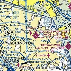
| Sectional chart |
|---|
|
| Airport distance calculator |
|---|
|
|
| Sunrise and sunset |
|---|
|
Times for 12-Feb-2026
| | Local
(UTC-5) | | Zulu
(UTC) |
|---|
| Morning civil twilight | | 06:36 | | 11:36 |
| Sunrise | | 07:04 | | 12:04 |
| Sunset | | 17:40 | | 22:40 |
| Evening civil twilight | | 18:08 | | 23:08 |
|
| Current date and time |
|---|
| Zulu (UTC) | 12-Feb-2026 16:04:41 |
|---|
| Local (UTC-5) | 12-Feb-2026 11:04:41 |
|---|
|
| METAR |
|---|
| KCGS | 121555Z AUTO 29010G18KT 10SM OVC045 02/M08 A3016 RMK AO2 T00171081
|
KDCA
9nm SW | 121552Z 34016KT 10SM OVC050 02/M07 A3015 RMK AO2 PK WND 01031/1504 SLP207 T00171072 $
|
KFME
10nm NE | 121555Z AUTO 32008G18KT 280V350 10SM BKN048 01/M08 A3016 RMK AO1
|
KADW
10nm S | 121455Z 34013G18KT 10SM SCT050 01/M08 A3012 RMK AO2A SLP209 T00121081 52013 $
|
KBWI
16nm NE | 121554Z 31013G26KT 10SM FEW045 BKN055 01/M09 A3012 RMK AO2 PK WND 30031/1458 SLP200 T00111094
|
KGAI
16nm NW | 121556Z AUTO 32010G23KT 280V360 10SM OVC044 00/M08 A3013 RMK AO2 UPE02 SLP223 P0000 T00001078 FZRANO
|
KDAA
20nm SW | 121555Z AUTO 31009G17KT 10SM BKN043 03/M07 A3013 RMK AO2 SLP206 T00271072 $
|
|
| TAF |
|---|
KDCA
9nm SW | 121121Z 1212/1318 34009G19KT P6SM OVC050 FM121700 31013G22KT P6SM SCT250 FM130000 32008G16KT P6SM BKN250 FM130900 33008KT P6SM SKC
|
KADW
10nm S | 121000Z 1210/1315 33012G25KT 9999 BKN050 620505 510005 QNH3001INS BECMG 1216/1217 33012G28KT 9999 FEW050 SCT200 510005 QNH3003INS BECMG 1222/1223 33012G18KT 9999 FEW050 SCT200 510105 QNH3008INS BECMG 1300/1301 33012G18KT 9999 SCT050 BKN200 510105 QNH3011INS BECMG 1312/1313 33012G18KT 9999 FEW050 BKN250 510105 QNH3020INS TX04/1218Z TNM01/1308Z
|
KBWI
16nm NE | 121121Z 1212/1318 31012G21KT P6SM OVC050 FM121700 31013G22KT P6SM SCT250 FM130000 31008G16KT P6SM BKN250 FM130900 30006KT P6SM SCT250
|
KDAA
20nm SW | 121300Z 1213/1319 33012G18KT 9999 BKN045 620456 520105 QNH3006INS TEMPO 1213/1224 33015G25KT BECMG 1223/1224 33012G18KT 9999 FEW050 BKN250 510105 QNH3010INS BECMG 1308/1309 33009KT 9999 FEW250 510105 QNH3014INS BECMG 1312/1313 33012G18KT 9999 BKN025 620258 510105 QNH3020INS TX04/1219Z TNM04/1311Z
|
|
| NOTAMs |
|---|
NOTAMs are issued by the DoD/FAA and will open in a separate window not controlled by AirNav.
|
|

