FAA INFORMATION EFFECTIVE 11 JUNE 2026
Location
| FAA Identifier: | EYF |
| Lat/Long: | 34-36-06.5360N 078-34-45.3950W
34-36.108933N 078-34.756583W
34.6018156,-78.5792764
(estimated) |
| Elevation: | 131.3 ft. / 40.0 m (surveyed) |
| Variation: | 08W (2000) |
| From city: | 2 miles SE of ELIZABETHTOWN, NC |
| Time zone: | UTC -4 (UTC -5 during Standard Time) |
| Zip code: | 28337 |
Airport Operations
| Airport use: | Open to the public |
| Activation date: | 02/1947 |
| Control tower: | no |
| ARTCC: | WASHINGTON CENTER |
| FSS: | RALEIGH FLIGHT SERVICE STATION |
| NOTAMs facility: | EYF (NOTAM-D service available) |
| Attendance: | MON-SAT 0800-1700
FOR SVC AFTER HRS & EMERG CALL 910-862-4522. UNATNDD THANKSGIVING, CHRISTMAS, AND NEW YEARS DAY. |
| Wind indicator: | lighted |
| Segmented circle: | yes |
| Lights: | ACTVT REIL RWY 15 & 33 - CTAF. PAPI RWY 15 & 33 ON DAWN TO 0100 OR WHEN MIRL RWY 15/33 ON. AFTER 0100 ACTVT MIRL RWY 15/33 AND TWY - CTAF. |
| Beacon: | white-green (lighted land airport)
Operates sunset to sunrise. |
Airport Communications
| CTAF/UNICOM: | 122.8 |
| WX AWOS-3P: | 119.475 (910-862-9982) |
| FAYETTEVILLE APPROACH: | 133.0 |
| FAYETTEVILLE DEPARTURE: | 133.0 |
Nearby radio navigation aids
| VOR radial/distance | | VOR name | | Freq | | Var |
|---|
| FAYr152/27.2 | | FAYETTEVILLE VOR/DME | | 114.85 | | 04W |
| ILMr300/38.0 | | WILMINGTON VORTAC | | 117.00 | | 07W |
| NDB name | | Hdg/Dist | | Freq | | Var | | ID |
|---|
| CLINTON | | 215/24.8 | | 412 | | 09W | | CTZ | -.-. - --.. |
Airport Services
| Fuel available: | 100LL JET-A1+
100LL:SELF SVC FUEL AVBL 24 HRS WITH CREDIT CARD. |
| Parking: | hangars and tiedowns |
| Airframe service: | MINOR |
| Powerplant service: | MINOR |
| Bottled oxygen: | NONE |
| Bulk oxygen: | NONE |
Runway Information
Runway 15/33
| Dimensions: | 5006 x 75 ft. / 1526 x 23 m |
| Surface: | asphalt, in good condition |
| Weight bearing capacity: | | Single wheel: | 30.0 | | Double wheel: | 45.0 |
|
| Runway edge lights: | medium intensity |
| RUNWAY 15 | | RUNWAY 33 |
| Latitude: | 34-36.443455N | | 34-35.774405N |
| Longitude: | 078-35.048678W | | 078-34.464533W |
| Elevation: | 128.4 ft. | | 121.5 ft. |
| Traffic pattern: | left | | left |
| Runway heading: | 152 magnetic, 144 true | | 332 magnetic, 324 true |
| Markings: | nonprecision, in good condition | | nonprecision, in good condition |
| Visual slope indicator: | 2-light PAPI on left (3.00 degrees glide path) | | 2-light PAPI on left (3.00 degrees glide path) |
| Runway end identifier lights: | yes | | yes |
| Touchdown point: | yes, no lights | | yes, no lights |
| Obstructions: | 6 ft. fence, 248 ft. from runway, 192 ft. left of centerline, 8:1 slope to clear
HAS 6 FT FENCE 0 TO 200 FT FM THR OFFSET 250 FT L OF CNTRLN. | | 103 ft. trees, 3980 ft. from runway, 390 ft. left of centerline, 36:1 slope to clear |
Airport Ownership and Management from official FAA records
| Ownership: | Publicly-owned |
| Owner: | TOWN OF ELIZABETHTOWN
PO BOX 716
ELIZABETHTOWN, NC 28337
Phone 910-862-2066 |
| Manager: | KEN HADAWAY
466 AIRPORT RD
ELIZABETHTOWN, NC 28337
Phone 910-862-4522 |
Additional Remarks
| - | DEER & BIRDS ON AND INVOF ARPT. |
| - | LOW LEVEL MIL ACT INVOF ARPT. |
| - | BCN OBSCURED BY TREES TO THE EAST. |
| - | FOR CD CTC WASHINGTON ARTCC AT 703-771-3587. |
| - | 10 FT DITCH ALONG LEFT SIDE TWY A TOWARD RWY 33. |
Instrument Procedures
NOTE: All procedures below are presented as PDF files. If you need a reader for these files, you should download the free Adobe Reader.NOT FOR NAVIGATION. Please procure official charts for flight.
FAA instrument procedures published for use from 11 June 2026 at 0901Z to 09 July 2026 at 0900z.
IAPs - Instrument Approach Procedures |
|---|
| RNAV (GPS) RWY 15 | |
download (255KB) |
| RNAV (GPS) RWY 33 | |
download (258KB) |
| VOR/DME RWY 15 | |
download (202KB) |
| NOTE: Special Alternate Minimums apply | |
download (166KB) |
| NOTE: Special Take-Off Minimums/Departure Procedures apply | |
download (364KB) |
Other nearby airports with instrument procedures:
KCPC - Columbus County Regional Airport (21 nm S)
KLBT - Lumberton Regional Airport (24 nm W)
KCTZ - Clinton-Sampson County Airport (25 nm NE)
KFAY - Fayetteville Regional Airport/Grannis Field (28 nm NW)
KACZ - Wallace-Pender Airport (29 nm E)
|
|

Road maps at:
MapQuest
Bing
Google
| Aerial photo |
|---|
WARNING: Photo may not be current or correct

Do you have a better or more recent aerial photo of Curtis L Brown Jr. Field Airport that you would like to share? If so, please send us your photo.
|
| Sectional chart |
|---|
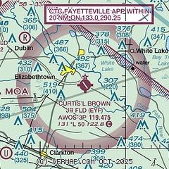
|
| Airport distance calculator |
|---|
|
|
| Sunrise and sunset |
|---|
|
Times for 04-Jul-2026
| | Local
(UTC-4) | | Zulu
(UTC) |
|---|
| Morning civil twilight | | 05:38 | | 09:38 |
| Sunrise | | 06:07 | | 10:07 |
| Sunset | | 20:30 | | 00:30 |
| Evening civil twilight | | 20:59 | | 00:59 |
|
| Current date and time |
|---|
| Zulu (UTC) | 04-Jul-2026 16:22:21 |
|---|
| Local (UTC-4) | 04-Jul-2026 12:22:21 |
|---|
|
| METAR |
|---|
| KEYF | 041555Z AUTO 20007KT 10SM CLR 32/22 A3005 RMK AO2 T03200224
|
|
| TAF |
|---|
KLBT
24nm W | 041120Z 0412/0512 00000KT P6SM SKC FM041700 16005KT P6SM FEW250 FM050000 16007KT P6SM SKC
|
KFAY
27nm NW | 041120Z 0412/0512 21005KT P6SM SCT250
|
|
| NOTAMs |
|---|
NOTAMs are issued by the DoD/FAA and will open in a separate window not controlled by AirNav.
|
|


