FAA INFORMATION EFFECTIVE 22 JANUARY 2026
Location
| FAA Identifier: | MWC |
| Lat/Long: | 43-06-37.3680N 088-02-03.9060W
43-06.622800N 088-02.065100W
43.1103800,-88.0344183
(estimated) |
| Elevation: | 744.8 ft. / 227.0 m (surveyed) |
| Variation: | 02W (1990) |
| From city: | 5 miles NW of MILWAUKEE, WI |
| Time zone: | UTC -6 (UTC -5 during Daylight Saving Time) |
| Zip code: | 53225 |
Airport Operations
| Airport use: | Open to the public |
| Activation date: | 08/1937 |
| Control tower: | yes |
| ARTCC: | CHICAGO CENTER |
| FSS: | GREEN BAY FLIGHT SERVICE STATION |
| NOTAMs facility: | MWC (NOTAM-D service available) |
| Attendance: | 0800-1600 |
| Wind indicator: | yes |
| Segmented circle: | no |
| Lights: | WHEN ATCT CLSD, MIRL RWY 15L/33R PRESET TO LOW SS-SR; TO INCR INTST AND ACTVT REIL RWY 04L, 15L, 22R, & 33R; PAPI RWY 15L & 33R; VASI RWY 04L & 22R; AND MIRL RWY 04L/22R - CTAF. |
| Beacon: | white-green (lighted land airport)
Operates sunset to sunrise. |
Airport Communications
| CTAF: | 120.5 |
| UNICOM: | 122.95 |
| ATIS: | 128.3 |
| WX AWOS-3: | PHONE 414-461-2954 |
| TIMMERMAN GROUND: | 121.7 [0700-2100] |
| TIMMERMAN TOWER: | 120.5 [0700-2100] |
| MILWAUKEE APPROACH: | 125.35 |
| MILWAUKEE DEPARTURE: | 125.35 |
| CLEARANCE DELIVERY: | 121.7 ;WHEN TWR CLSD |
| GOPAC STAR: | 126.5 |
| WX AWOS-3 at UES (10 nm SW): | 118.875 (262-521-5226) |
| WX ASOS at MKE (12 nm SE): | 126.4 (414-400-9402) |
| WX AWOS-3 at ETB (19 nm N): | 120.0 (262-334-6161) |
Nearby radio navigation aids
| VOR radial/distance | | VOR name | | Freq | | Var |
|---|
| BAEr090/11.0 | | BADGER VOR/DME | | 116.40 | | 02E |
| BJBr169/(19.1) | | WEST BEND VOR | | 109.80 | | 01W |
| NDB name | | Hdg/Dist | | Freq | | Var | | ID |
|---|
| ROCK RIVER | | 098/30.5 | | 371 | | 01W | | RYV | .-. -.-- ...- |
Airport Services
| Fuel available: | 100LL JET-A+ |
| Parking: | hangars and tiedowns |
| Airframe service: | MAJOR |
| Powerplant service: | MAJOR |
| Bottled oxygen: | HIGH/LOW |
| Bulk oxygen: | HIGH/LOW |
Runway Information
Runway 15L/33R
| Dimensions: | 4107 x 75 ft. / 1252 x 23 m |
| Surface: | asphalt, in excellent condition |
| Weight bearing capacity: | |
| Runway edge lights: | medium intensity |
| RUNWAY 15L | | RUNWAY 33R |
| Latitude: | 43-06.949187N | | 43-06.391575N |
| Longitude: | 088-02.317427W | | 088-01.795722W |
| Elevation: | 744.1 ft. | | 743.7 ft. |
| Traffic pattern: | left | | left |
| Runway heading: | 148 magnetic, 146 true | | 328 magnetic, 326 true |
| Markings: | nonprecision, in good condition | | nonprecision, in good condition |
| Visual slope indicator: | 4-light PAPI on right (3.00 degrees glide path) | | 4-light PAPI on left (4.00 degrees glide path)
UNUSBL BYD 8 DEGS RIGHT OF CNTRLN. WHEN PAPI OTS, RWY CLSD TO LDG SS-SR. |
| Runway end identifier lights: | yes | | yes |
| Touchdown point: | yes, no lights | | yes, no lights |
| Instrument approach: | LOCALIZER | | |
| Obstructions: | none | | 35 ft. tree, 830 ft. from runway, 25 ft. right of centerline, 18:1 slope to clear |
Runway 4L/22R
| Dimensions: | 3203 x 75 ft. / 976 x 23 m |
| Surface: | asphalt, in excellent condition |
| Weight bearing capacity: | |
| Runway edge lights: | medium intensity |
| RUNWAY 4L | | RUNWAY 22R |
| Latitude: | 43-06.426040N | | 43-06.851553N |
| Longitude: | 088-02.287255W | | 088-01.862467W |
| Elevation: | 737.2 ft. | | 738.4 ft. |
| Traffic pattern: | left | | left |
| Runway heading: | 038 magnetic, 036 true | | 218 magnetic, 216 true |
| Markings: | nonprecision, in good condition | | nonprecision, in good condition |
| Visual slope indicator: | 4-box VASI on left (4.00 degrees glide path)
WHEN VASI OTS, RWY CLSD TO LDG SS-SR. | | 4-box VASI on left (4.00 degrees glide path)
WHEN VASI OTS, RWY CLSD TO LDG SS-SR. |
| Runway end identifier lights: | yes | | yes |
| Touchdown point: | yes, no lights | | yes, no lights |
| Obstructions: | none | | 29 ft. tree, 700 ft. from runway, 250 ft. left of centerline, 17:1 slope to clear |
Runway 15R/33L
| Dimensions: | 3231 x 270 ft. / 985 x 82 m |
| Surface: | turf, in good condition |
| Runway edge markings: | MKD BY WHITE TFC CONES. |
| RUNWAY 15R | | RUNWAY 33L |
| Latitude: | 43-06.810742N | | 43-06.371837N |
| Longitude: | 088-02.350987W | | 088-01.940898W |
| Elevation: | 742.3 ft. | | 733.3 ft. |
| Traffic pattern: | left | | left |
| Runway heading: | 147 magnetic, 145 true | | 327 magnetic, 325 true |
| Runway end identifier lights: | no | | no |
| Touchdown point: | yes, no lights | | yes, no lights |
| Obstructions: | none | | 50 ft. tree, 800 ft. from runway, 50 ft. left of centerline, 16:1 slope to clear |
Runway 4R/22L
| Dimensions: | 2840 x 270 ft. / 866 x 82 m |
| Surface: | turf, in good condition |
| Runway edge markings: | MKD BY WHITE TFC CONES. |
| RUNWAY 4R | | RUNWAY 22L |
| Latitude: | 43-06.383077N | | 43-06.760428N |
| Longitude: | 088-02.162723W | | 088-01.786153W |
| Elevation: | 732.0 ft. | | 736.4 ft. |
| Traffic pattern: | left | | left |
| Runway heading: | 038 magnetic, 036 true | | 218 magnetic, 216 true |
| Runway end identifier lights: | no | | no |
| Touchdown point: | yes, no lights | | yes, no lights |
| Obstructions: | 50 ft. trees, 915 ft. from runway, 14:1 slope to clear | | 53 ft. trees, 800 ft. from runway, 150 ft. left of centerline, 15:1 slope to clear |
Airport Ownership and Management from official FAA records
| Ownership: | Publicly-owned |
| Owner: | MILWAUKEE COUNTY
COUNTY COURTHOUSE
MILWAUKEE, WI 53233
Phone 414-747-5300 |
| Manager: | BRIAN DRANZIK
5300 S HOWELL
MILWAUKEE, WI 53207
Phone 414-747-5775
EMAIL ADDRESS: BDRANZIK@MITCHELLAIRPORT.COM (ALL LOWER CASE) |
Additional Remarks
| - | BCN ELEV 797' MSL. |
| - | TURF RYS 04R/22L & 15R/33L & ALL TURF TWYS CLSD 15 OCT - 1 MAY. |
| - | BIRDS ON & INVOF ARPT. |
| - | CONDS UNMON MON-FRI 1530-0630, SAT, SUN, OR FED HOLS. |
Instrument Procedures
NOTE: All procedures below are presented as PDF files. If you need a reader for these files, you should download the free Adobe Reader.NOT FOR NAVIGATION. Please procure official charts for flight.
FAA instrument procedures published for use from 22 January 2026 at 0901Z to 19 February 2026 at 0900z.
STARs - Standard Terminal Arrivals |
|---|
| GOPAC THREE (RNAV) | |
download (233KB) |
IAPs - Instrument Approach Procedures |
|---|
| RNAV (GPS) RWY 04L | |
download (249KB) |
| RNAV (GPS) RWY 15L | |
download (277KB) |
| RNAV (GPS) RWY 22R | |
download (257KB) |
| LOC RWY 15L | |
download (269KB) |
| NOTE: Special Alternate Minimums apply | |
download (161KB) |
Departure Procedures |
|---|
| ACCRA FIVE (RNAV) | |
download (171KB) |
| UECKR SIX (RNAV) | |
download (188KB) |
| NOTE: Special Take-Off Minimums/Departure Procedures apply | |
download (208KB) |
Other nearby airports with instrument procedures:
KUES - Waukesha County Airport (10 nm SW)
KMKE - General Mitchell International Airport (12 nm SE)
KETB - West Bend Municipal Airport (19 nm N)
KHXF - Hartford Municipal Airport (21 nm NW)
KRAC - Batten International Airport (23 nm SE)
|
|

Road maps at:
MapQuest
Bing
Google
| Aerial photo |
|---|
WARNING: Photo may not be current or correct
 Photo by Dan Weber
Photo taken 09-Mar-2009
looking northeast.
Photo by Dan Weber
Photo taken 09-Mar-2009
looking northeast.
Do you have a better or more recent aerial photo of Lawrence J Timmerman Airport that you would like to share? If so, please send us your photo.
|
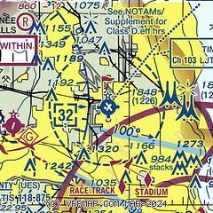
| Sectional chart |
|---|
|
 Download PDF
of official airport diagram from the FAA
| Airport distance calculator |
|---|
|
|
| Sunrise and sunset |
|---|
|
Times for 13-Feb-2026
| | Local
(UTC-6) | | Zulu
(UTC) |
|---|
| Morning civil twilight | | 06:24 | | 12:24 |
| Sunrise | | 06:54 | | 12:54 |
| Sunset | | 17:19 | | 23:19 |
| Evening civil twilight | | 17:48 | | 23:48 |
|
| Current date and time |
|---|
| Zulu (UTC) | 14-Feb-2026 04:22:21 |
|---|
| Local (UTC-6) | 13-Feb-2026 22:22:21 |
|---|
|
| METAR |
|---|
| KMWC | 140355Z AUTO 00000KT 10SM CLR 00/M02 A3006 RMK AO2
|
KUES
7nm SW | 140355Z AUTO 00000KT 10SM CLR 00/M02 A3005 RMK AO2
|
KMKE
11nm SE | 140352Z 00000KT 10SM CLR 02/M02 A3004 RMK AO2 SLP180 T00171022
|
KETB
19nm N | 140355Z AUTO 00000KT 10SM CLR 01/00 A3004 RMK AO2
|
|
| TAF |
|---|
KUES
7nm SW | 132041Z 1321/1418 24010KT P6SM SKC FM140000 VRB03KT P6SM SKC FM141500 00000KT P6SM BKN250
|
KMKE
11nm SE | 132042Z 1321/1424 24012G18KT P6SM SKC FM132300 24006KT P6SM SKC FM140500 VRB03KT P6SM SKC FM141800 15005KT P6SM BKN250
|
|
| NOTAMs |
|---|
NOTAMs are issued by the DoD/FAA and will open in a separate window not controlled by AirNav.
|
|


