FAA INFORMATION EFFECTIVE 14 MAY 2026
Location
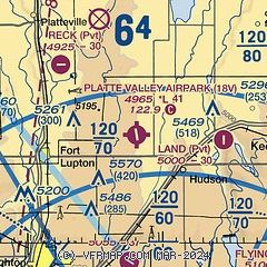
| FAA Identifier: | 18V |
| Lat/Long: | 40-06-09.8000N 104-42-04.3000W
40-06.163333N 104-42.071667W
40.1027222,-104.7011944
(estimated) |
| Elevation: | 4965 ft. / 1513 m (estimated) |
| Variation: | 11E (1985) |
| From city: | 3 miles NW of HUDSON, CO |
| Time zone: | UTC -6 (UTC -7 during Standard Time) |
| Zip code: | 80621 |
Airport Operations
| Airport use: | Open to the public |
| Activation date: | 03/1966 |
| Control tower: | no |
| ARTCC: | DENVER CENTER |
| FSS: | DENVER FLIGHT SERVICE STATION |
| NOTAMs facility: | DEN (NOTAM-D service available) |
| Attendance: | SR-SS, |
| Wind indicator: | yes |
| Segmented circle: | no |
Airport Communications
| CTAF: | 122.9 |
| WX ASOS at DEN (15 nm S): | PHONE 719-204-1223 |
| WX AWOS-3PT at EIK (17 nm W): | 133.825 (303-604-4339) |
Nearby radio navigation aids
| VOR radial/distance | | VOR name | | Freq | | Var |
|---|
| DVVr336/13.0 | | MILE HIGH VORTAC | | 114.70 | | 08E |
| DENr346/17.5 | | DENVER VOR/DME | | 117.90 | | 08E |
| BJCr050/23.1 | | JEFFCO VOR/DME | | 115.40 | | 11E |
| GLLr183/25.0 | | GILL VOR/DME | | 114.20 | | 13E |
| FQFr341/25.0 | | FALCON VORTAC | | 116.30 | | 11E |
Airport Services
| Fuel available: | 100LL
100LL:24 HR CREDIT CARD SVC AVBL. |
| Parking: | hangars and tiedowns |
| Airframe service: | MINOR |
| Powerplant service: | MINOR |
Runway Information
Runway 15/33
| Dimensions: | 4100 x 40 ft. / 1250 x 12 m |
| Surface: | asphalt, in poor condition
CRACKS & UNEVEN. |
| RUNWAY 15 | | RUNWAY 33 |
| Latitude: | 40-06.300875N | | 40-05.647133N |
| Longitude: | 104-42.163087W | | 104-41.941872W |
| Traffic pattern: | left | | left |
| Runway heading: | 154 magnetic, 165 true | | 334 magnetic, 345 true |
| Markings: | basic, in fair condition | | basic, in fair condition |
Runway 9/27
| Dimensions: | 2500 x 90 ft. / 762 x 27 m |
| Surface: | turf/gravel, in fair condition |
| Operational restrictions: | -3 FT DITCH 45 FT N FULL LEN. |
| RUNWAY 9 | | RUNWAY 27 |
| Latitude: | 40-06.524833N | | 40-06.420667N |
| Longitude: | 104-42.363000W | | 104-41.844000W |
| Traffic pattern: | left | | left |
| Obstructions: | 46 ft. tree, 87 ft. from runway, 1:1 slope to clear | | 17 ft. road, 64 ft. from runway, 3:1 slope to clear |
Airport Ownership and Management from official FAA records
| Ownership: | Privately-owned |
| Owner: | 18V MANAGEMENT
7507 WELD COUNTY RD 39
FORT LUPTON, CO 80621
Phone 720-914-3854 |
| Manager: | ERIN SHOFFIT
7507 CO RD 39
FORT LUPTON, CO 80621
Phone 720-914-3854 |
Additional Remarks
| A30A-27 | +20 FT POLE & +15 FT TANK 185 FT FM THR 90 FT L OF CNTRLN; +30 FT POLE 30 FT FM THR 90 FT L & R OF CNTRLN; +15 FT HNGR 155 FT W OF THR 75 FT N OF CNTRLN. |
| A57-15 | RISING GND APPROX 555 FT FM RY APPCH END 16 FT ABV RY END PRODUCES 22:1 CLNC SLOPE. |
| - | DIRT TWY SOFT WHEN WET. |
| - | POLE APPROX 221 FT FM RY 15 APCH END, 1 FT ABV RY END PRODUCES 21:1 CLNC SLOPE. |
| - | 33 FT TREE APPROX 48 FT RIGHT OF RY EDGE, 200FT WEST OF RY THLD. |
| - | CODE FOR FBO - CTAF. |
| - | TWY INT RWY 09/27 MID FIELD. |
| - | FOR CD CTC DENVER APCH AT 303-342-1916. |
| - | RWY'S UNLGTD; RWY'S MAY NOT BE MNTND IN WINTER, VFY COND PRIOR TO USE. |
Instrument Procedures
There are no published instrument procedures at 18V.
Some nearby airports with instrument procedures:
KDEN - Denver International Airport (15 nm S)
KEIK - Erie Municipal Airport (17 nm W)
KGXY - Greeley-Weld County Airport (20 nm N)
KCFO - Colorado Air and Space Port Airport (21 nm S)
KLMO - Vance Brand Airport (22 nm W)
|
|

Road maps at:
MapQuest
Bing
Google
| Aerial photo |
|---|
WARNING: Photo may not be current or correct
 Photo by Germaine and Matt
Photo taken 29-Mar-2020
looking north at 6000ft.
Photo by Germaine and Matt
Photo taken 29-Mar-2020
looking north at 6000ft.
Do you have a better or more recent aerial photo of Platte Valley Airpark that you would like to share? If so, please send us your photo.
|
| Sectional chart |
|---|
|
| Airport distance calculator |
|---|
|
|
| Sunrise and sunset |
|---|
|
Times for 31-May-2026
| | Local
(UTC-6) | | Zulu
(UTC) |
|---|
| Morning civil twilight | | 05:01 | | 11:01 |
| Sunrise | | 05:33 | | 11:33 |
| Sunset | | 20:20 | | 02:20 |
| Evening civil twilight | | 20:52 | | 02:52 |
|
| Current date and time |
|---|
| Zulu (UTC) | 31-May-2026 09:13:55 |
|---|
| Local (UTC-6) | 31-May-2026 03:13:55 |
|---|
|
| METAR |
|---|
KDEN
16nm S | 310853Z 25005KT 10SM FEW120 12/02 A2999 RMK AO2 SLP094 T01220022 56004 $
|
KEIK
17nm W | 310855Z AUTO 27008KT 10SM CLR 16/M00 A2997 RMK AO2 T01571002 $
|
KGXY
19nm N | 310856Z AUTO RMK AO2 SLPNO 6//// PWINO FZRANO $
|
|
| TAF |
|---|
KDEN
16nm S | 310533Z 3106/0112 VRB05KT P6SM FEW120 SCT220 TEMPO 3106/3108 30011KT FM311000 21011KT P6SM SKC FM311700 28011G18KT P6SM FEW120 FM312300 01011KT P6SM FEW120 FM010200 04008KT P6SM FEW120 FM010500 13008KT P6SM FEW120 FM010800 19009KT P6SM FEW120 SCT220
|
|
| NOTAMs |
|---|
NOTAMs are issued by the DoD/FAA and will open in a separate window not controlled by AirNav.
|
|

