FAA INFORMATION EFFECTIVE 16 APRIL 2026
Location
| FAA Identifier: | GXY |
| Lat/Long: | 40-26-14.7000N 104-37-59.6000W
40-26.245000N 104-37.993333W
40.4374167,-104.6332222
(estimated) |
| Elevation: | 4696.8 ft. / 1431.6 m (surveyed) |
| Variation: | 08E (2015) |
| From city: | 3 miles E of GREELEY, CO |
| Time zone: | UTC -6 (UTC -7 during Standard Time) |
| Zip code: | 80631 |
Airport Operations
| Airport use: | Open to the public |
| Activation date: | 10/1944 |
| Control tower: | no |
| ARTCC: | DENVER CENTER |
| FSS: | DENVER FLIGHT SERVICE STATION |
| NOTAMs facility: | GXY (NOTAM-D service available) |
| Attendance: | 0600-1900
COORD AFT HR ARPT ACES WITH FBO'S. CALL 970-336-4866 OR 970-351-8957.
FOR ATNDNC AFT HRS CALL 970-336-3010. |
| Pattern altitude: | 5496.8 ft. MSL |
| Wind indicator: | lighted |
| Segmented circle: | yes |
| Lights: | ACTVT MIRL RWYS 10/28 & 17/35, & REIL RWYS 10, 28, 17, & 35 - CTAF. PAPI RWYS 10, 17, 35, & VASI RWY 28 OPR 24 HRS. |
| Beacon: | white-green (lighted land airport)
Operates sunset to sunrise. |
Airport Communications
| CTAF/UNICOM: | 122.7 |
| WX AWOS-3PT: | 135.175 (970-352-3511) |
| DENVER APPROACH: | 134.85 |
| DENVER DEPARTURE: | 134.85 |
| CLEARANCE DELIVERY: | 126.65 |
| BRNKO RNAV STAR: | 127.05 |
| DANDD STAR: | 120.35 |
| LARKS: | 120.35 |
| POWDR STAR: | 120.35 |
| QUAIL STAR: | 120.35 |
| RAMMS STAR: | 120.35 |
| TOMSN STAR: | 119.3 |
| WX AWOS-3PT at FNL (17 nm W): | 135.075 (970-669-9187) |
- COMMUNICATIONS PRVDD BY DENVER RADIO ON FREQ 122.5 (GILL RCO).
Nearby radio navigation aids
| VOR radial/distance | | VOR name | | Freq | | Var |
|---|
| GLLr210/5.4 | | GILL VOR/DME | | 114.20 | | 13E |
| DVVr351/32.6 | | MILE HIGH VORTAC | | 114.70 | | 08E |
| DENr354/37.5 | | DENVER VOR/DME | | 117.90 | | 08E |
| BJCr025/39.1 | | JEFFCO VOR/DME | | 115.40 | | 11E |
Airport Services
| Fuel available: | 100LL JET-A |
| Parking: | hangars and tiedowns |
| Airframe service: | MAJOR |
| Powerplant service: | MAJOR |
| Bottled oxygen: | HIGH/LOW |
Runway Information
Runway 17/35
| Dimensions: | 10000 x 100 ft. / 3048 x 30 m |
| Surface: | asphalt, in good condition |
| Weight bearing capacity: | | Single wheel: | 30.0 | | Double wheel: | 45.0 |
|
| Runway edge lights: | medium intensity |
| RUNWAY 17 | | RUNWAY 35 |
| Latitude: | 40-27.374960N | | 40-25.729570N |
| Longitude: | 104-37.934213W | | 104-37.851772W |
| Elevation: | 4696.8 ft. | | 4648.5 ft. |
| Traffic pattern: | left | | left |
| Runway heading: | 169 magnetic, 177 true | | 349 magnetic, 357 true |
| Displaced threshold: | no | | 1100 ft. |
| Markings: | precision, in good condition | | precision, in good condition |
| Visual slope indicator: | 2-light PAPI on left (3.00 degrees glide path) | | 2-light PAPI on left (3.00 degrees glide path) |
| Runway end identifier lights: | yes | | yes |
| Touchdown point: | yes, no lights | | yes, no lights |
| Instrument approach: | | | ILS/DME |
Runway 10/28
| Dimensions: | 5801 x 100 ft. / 1768 x 30 m |
| Surface: | asphalt, in excellent condition |
| Weight bearing capacity: | | Single wheel: | 18.0 | | Double wheel: | 30.0 |
|
| Runway edge lights: | medium intensity |
| RUNWAY 10 | | RUNWAY 28 |
| Latitude: | 40-25.841232N | | 40-25.587247N |
| Longitude: | 104-38.766978W | | 104-37.562078W |
| Elevation: | 4661.2 ft. | | 4644.8 ft. |
| Traffic pattern: | left | | right |
| Runway heading: | 097 magnetic, 105 true | | 277 magnetic, 285 true |
| Markings: | precision, in good condition | | precision, in good condition |
| Visual slope indicator: | 2-light PAPI on left (3.00 degrees glide path) | | 4-box VASI on left (3.00 degrees glide path) |
| Runway end identifier lights: | yes | | yes |
| Touchdown point: | yes, no lights | | yes, no lights |
Helipad H1
| Dimensions: | 20 x 20 ft. / 6 x 6 m |
| Surface: | concrete, in good condition |
| Runway edge lights: | PERI |
| Latitude: | 40-25.628833N | | |
| Longitude: | 104-38.282000W | | |
| Elevation: | 4643.0 ft. | | |
| Traffic pattern: | left | | left |
| Markings: | basic, in good condition | | |
Helipad H2
| Dimensions: | 20 x 20 ft. / 6 x 6 m |
| Surface: | concrete, in good condition |
| Runway edge lights: | PERI |
| Latitude: | 40-25.613500N | | |
| Longitude: | 104-38.195000W | | |
| Elevation: | 4642.0 ft. | | |
| Traffic pattern: | left | | left |
| Markings: | none, in poor condition | | |
Airport Ownership and Management from official FAA records
| Ownership: | Publicly-owned |
| Owner: | GREELEY-WELD CO ARPT AUTH
PO BOX 727
GREELEY, CO 80632
Phone 970-336-3000 |
| Manager: | COOPER ANDERSON
PO BOX 727
GREELEY, CO 80632
Phone (970) 336-3001 |
Additional Remarks
| A58-10 | 10 FT DIRT ACES ROAD AT THLD & PARL TO EXTDD CNTRLN; 9 FT CROPS 140 FT FM THLD 90 FT LEFT & RIGHT OF CNTRLN. |
| - | RWY 17/35 PREFERRED USE WHEN X WIND CMPT EXCEEDS 12 KT ON RWY 10/28. |
| - | RWY 35 PREFERRED USE WHEN WIND LESS THAN 5 KTS. RWY 35 PREFERRED FOR TGL. |
| - | WILDLIFE & BIRDS ON & INVOF APRT. |
| - | OIL DRILLING RIGS UP TO 120 FT ON AND INVOF ARPT. |
| - | BE ALERT; INTENSIVE USAF STUDENT TRNG INVOF COLORADO SPRINGS & PUEBLO COLORADO. |
| - | ACFT DEPG RWY 28 AVOID SB TURN PRIOR TO XG RWY 10 THLD. |
Instrument Procedures
NOTE: All procedures below are presented as PDF files. If you need a reader for these files, you should download the free Adobe Reader.NOT FOR NAVIGATION. Please procure official charts for flight.
FAA instrument procedures published for use from 16 April 2026 at 0901Z to 14 May 2026 at 0900Z.
STARs - Standard Terminal Arrivals |
|---|
| BRNKO FOUR (RNAV) | |
2 pages:
[1] [2] (290KB) |
| BRNKO FOUR (RNAV), CONT.2 | |
download (252KB) |
| DANDD ONE | |
2 pages:
[1] [2] (325KB) |
| LANDR THREE | |
2 pages:
[1] [2] (347KB) |
| LARKS THREE | |
2 pages:
[1] [2] (352KB) |
| PINNR THREE (RNAV) | |
2 pages:
[1] [2] (365KB) |
| POWDR ONE | |
2 pages:
[1] [2] (326KB) |
| QUAIL ONE | |
download (250KB) |
| RAMMS EIGHT | |
2 pages:
[1] [2] (309KB) |
| TOMSN NINE | |
2 pages:
[1] [2] (339KB) |
IAPs - Instrument Approach Procedures |
|---|
| ILS OR LOC RWY 35 | |
download (285KB) |
| RNAV (GPS) RWY 10 | |
download (225KB) |
| RNAV (GPS) RWY 17 | |
download (243KB) |
| RNAV (GPS) RWY 28 | |
download (259KB) |
| RNAV (GPS) RWY 35 | |
download (220KB) |
| VOR-A | |
download (246KB) |
| NOTE: Special Alternate Minimums apply | |
download (54KB) |
Departure Procedures |
|---|
| DENVER THREE | |
2 pages:
[1] [2] (262KB) |
| ECHOO ONE (RNAV) | |
2 pages:
[1] [2] (312KB) |
| MRSHH TWO (RNAV) | |
2 pages:
[1] [2] (307KB) |
| PIKES THREE | |
download (235KB) |
| PLAINS TWO | |
2 pages:
[1] [2] (426KB) |
| ROCKIES SEVEN | |
2 pages:
[1] [2] (377KB) |
| SKYEE ONE (RNAV) | |
2 pages:
[1] [2] (313KB) |
| WNGSS ONE (RNAV) | |
2 pages:
[1] [2] (357KB) |
| YELLOWSTONE FIVE | |
2 pages:
[1] [2] (374KB) |
| NOTE: Special Take-Off Minimums/Departure Procedures apply | |
download |
Other nearby airports with instrument procedures:
KFNL - Northern Colorado Regional Airport (17 nm W)
KLMO - Vance Brand Airport (29 nm SW)
KEIK - Erie Municipal Airport (32 nm SW)
KDEN - Denver International Airport (35 nm S)
KFMM - Fort Morgan Municipal Airport (38 nm E)
|
|

Road maps at:
MapQuest
Bing
Google
| Aerial photo |
|---|
WARNING: Photo may not be current or correct
 Photo by Ron Lee
Photo taken 17-Dec-2004
From about 3800' AGL South of airprot facing north
Photo by Ron Lee
Photo taken 17-Dec-2004
From about 3800' AGL South of airprot facing north
Do you have a better or more recent aerial photo of Greeley-Weld County Airport that you would like to share? If so, please send us your photo.
|
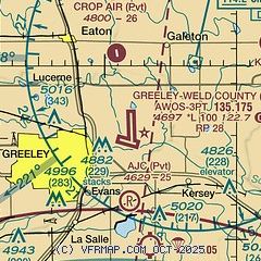
| Sectional chart |
|---|
|
CAUTION: Diagram may not be current
 Download PDF
of official airport diagram from the FAA
| Airport distance calculator |
|---|
|
|
| Sunrise and sunset |
|---|
|
Times for 21-Apr-2026
| | Local
(UTC-6) | | Zulu
(UTC) |
|---|
| Morning civil twilight | | 05:43 | | 11:43 |
| Sunrise | | 06:12 | | 12:12 |
| Sunset | | 19:42 | | 01:42 |
| Evening civil twilight | | 20:11 | | 02:11 |
|
| Current date and time |
|---|
| Zulu (UTC) | 21-Apr-2026 07:44:32 |
|---|
| Local (UTC-6) | 21-Apr-2026 01:44:32 |
|---|
|
| METAR |
|---|
| KGXY | 210656Z AUTO RMK AO2 SLPNO PWINO FZRANO $
|
KFNL
18nm W | 210656Z 35004KT 10SM CLR 13/M09 A3003 RMK AO2 SLP115 T01281089 402830028 $
|
|
| TAF |
|---|
KDEN
36nm S | 210529Z 2106/2212 17011KT P6SM SCT200 FM210630 20009KT P6SM FEW220 FM211600 VRB06KT P6SM FEW220 FM211900 11008KT P6SM FEW140 FEW220 FM212200 12011G17KT P6SM SCT140 SCT200 FM220200 15012G18KT P6SM SCT140 BKN200 FM220500 20010KT P6SM SCT140 BKN200
|
KBJC
38nm SW | 210529Z 2106/2206 26007KT P6SM FEW220 FM211400 VRB05KT P6SM FEW220 FM211700 12008KT P6SM FEW140 SCT200 FM212200 09008KT P6SM FEW140 BKN220 FM220200 15008KT P6SM FEW140 BKN220
|
KCYS
44nm N | 210520Z 2106/2206 30008KT P6SM SKC FM211900 17009KT P6SM FEW120 SCT200
|
KBKF
44nm S | 210100Z 2101/2207 VRB06KT 9999 FEW110 FEW150 SCT220 QNH2990INS TX25/2120Z TN09/2112Z
|
|
| NOTAMs |
|---|
NOTAMs are issued by the DoD/FAA and will open in a separate window not controlled by AirNav.
|
|


