FAA INFORMATION EFFECTIVE 14 MAY 2026
Location
| FAA Identifier: | LMO |
| Lat/Long: | 40-09-51.8000N 105-09-49.1000W
40-09.863333N 105-09.818333W
40.1643889,-105.1636389
(estimated) |
| Elevation: | 5055.3 ft. / 1540.9 m (surveyed) |
| Variation: | 10E (2005) |
| From city: | 3 miles SW of LONGMONT, CO |
| Time zone: | UTC -6 (UTC -7 during Standard Time) |
| Zip code: | 80503 |
Airport Operations
| Airport use: | Open to the public |
| Activation date: | 10/1946 |
| Control tower: | no |
| ARTCC: | DENVER CENTER |
| FSS: | DENVER FLIGHT SERVICE STATION |
| NOTAMs facility: | DEN (NOTAM-D service available) |
| Attendance: | DAYLIGHT HOURS |
| Wind indicator: | lighted |
| Segmented circle: | yes |
| Lights: | ACTVT MIRL RY 11/29 AND VASI RY 11/29 - CTAF. |
| Beacon: | white-green (lighted land airport)
Operates sunset to sunrise. |
Airport Communications
| CTAF/UNICOM: | 122.975 |
| WX AWOS-3: | 120.0 (303-684-7545) |
| DENVER APPROACH: | 125.125 |
| DENVER DEPARTURE: | 125.125 |
| BRNKO RNAV STAR: | 127.05 |
| WX AWOS-3 at BDU (8 nm S): | 118.825 (303-541-9540) |
| WX AWOS-3PT at EIK (11 nm SE): | 133.825 (303-604-4339) |
| WX AWOS-3 at BJC (15 nm S): | PHONE 720-887-8067 |
| WX AWOS-3PT at FNL (19 nm N): | 135.075 (970-669-9187) |
Nearby radio navigation aids
| VOR radial/distance | | VOR name | | Freq | | Var |
|---|
| BJCr345/15.1 | | JEFFCO VOR/DME | | 115.40 | | 11E |
| DVVr295/29.6 | | MILE HIGH VORTAC | | 114.70 | | 08E |
| DENr304/31.3 | | DENVER VOR/DME | | 117.90 | | 08E |
| GLLr221/34.6 | | GILL VOR/DME | | 114.20 | | 13E |
| FQFr308/37.9 | | FALCON VORTAC | | 116.30 | | 11E |
Airport Services
| Fuel available: | 100LL JET-A MOGAS |
| Parking: | tiedowns |
| Airframe service: | MAJOR |
| Powerplant service: | MAJOR |
| Bottled oxygen: | NONE |
| Bulk oxygen: | NONE |
Runway Information
Runway 11/29
| Dimensions: | 4799 x 75 ft. / 1463 x 23 m |
| Surface: | concrete, in good condition |
| Weight bearing capacity: | |
| Runway edge lights: | medium intensity |
| RUNWAY 11 | | RUNWAY 29 |
| Latitude: | 40-10.076522N | | 40-09.650267N |
| Longitude: | 105-10.251705W | | 105-09.384468W |
| Elevation: | 5055.3 ft. | | 5031.1 ft. |
| Traffic pattern: | left | | left |
| Runway heading: | 113 magnetic, 123 true | | 293 magnetic, 303 true |
| Markings: | basic, in fair condition | | nonprecision, in fair condition |
| Visual slope indicator: | 2-box VASI on left (3.00 degrees glide path)
VASI UNUSLB BYD 3.9 NM. VASI DOES NOT PRVD OBST CLNC BYD 3.9 NM FROM THLD. | | 2-box VASI on left (3.00 degrees glide path) |
| Touchdown point: | yes, no lights | | yes, no lights |
| Obstructions: | 36 ft. tree, 826 ft. from runway, 68 ft. right of centerline, 17:1 slope to clear | | 8 ft. road, 436 ft. from runway, 29:1 slope to clear |
Airport Ownership and Management from official FAA records
| Ownership: | Publicly-owned |
| Owner: | CITY OF LONGMONT
350 KIMBARK ST
LONGMONT, CO 80501
Phone 303-651-8431 |
| Manager: | LEVI BROWN
229 AIRPORT ROAD
LONGMONT, CO 80503
Phone 303-651-8431 |
Additional Remarks
| - | FOR CD CTC DENVER APCH AT 303-342-1916. |
| - | ULTRALIGHT & HELICOPTER ACTIVITY ON & INVOF ARPT. |
| - | RY 11 HAS -7 FT DITCH 420 FT AND 900 FT FM THLD ON EXTDD THLD. |
| - | RY 29 HAS +15 FT HWY 702 FT FM THLD; +25 TO 35 FT BLDGS/TANKS APROXLY 1300 FT L OF THLD. |
| - | NOISE ABATEMENT PROCEDURES IN EFFECT CTC ARPT MANAGER 303-651-8431. |
| - | PARAJUMPING ON AND IN VICINITY OF ARPT PRIMARILY S OF RY, AVOID OVERFLIGHTS MID FIELD. |
Instrument Procedures
NOTE: All procedures below are presented as PDF files. If you need a reader for these files, you should download the free Adobe Reader.NOT FOR NAVIGATION. Please procure official charts for flight.
FAA instrument procedures published for use from 14 May 2026 at 0901Z to 11 June 2026 at 0900Z.
STARs - Standard Terminal Arrivals |
|---|
| BRNKO FOUR (RNAV) | |
2 pages:
[1] [2] (290KB) |
| BRNKO FOUR (RNAV), CONT.2 | |
download (252KB) |
| PINNR THREE (RNAV) | |
2 pages:
[1] [2] (366KB) |
IAPs - Instrument Approach Procedures |
|---|
| RNAV (GPS) RWY 29 | |
download (274KB) |
| RNAV (GPS)-B | |
download (287KB) |
| VOR/DME-A | |
download (299KB) |
| NOTE: Special Alternate Minimums apply | |
download (140KB) |
Departure Procedures |
|---|
| ECHOO ONE (RNAV) | |
2 pages:
[1] [2] (288KB) |
| MRSHH TWO (RNAV) | |
2 pages:
[1] [2] (284KB) |
| SKYEE ONE (RNAV) | |
2 pages:
[1] [2] (289KB) |
| WNGSS ONE (RNAV) | |
2 pages:
[1] [2] (333KB) |
| NOTE: Special Take-Off Minimums/Departure Procedures apply | |
download (287KB) |
Other nearby airports with instrument procedures:
KEIK - Erie Municipal Airport (11 nm SE)
KBJC - Rocky Mountain Metro Airport (15 nm S)
KFNL - Northern Colorado Regional Airport (19 nm N)
KDEN - Denver International Airport (29 nm SE)
KGXY - Greeley-Weld County Airport (29 nm NE)
|
|

Road maps at:
MapQuest
Bing
Google
| Aerial photo |
|---|
WARNING: Photo may not be current or correct
 Photo by Kyle D. Strunk
Photo taken 21-Apr-2020
looking west.
Photo by Kyle D. Strunk
Photo taken 21-Apr-2020
looking west.
Do you have a better or more recent aerial photo of Vance Brand Airport that you would like to share? If so, please send us your photo.
|
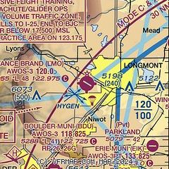
| Sectional chart |
|---|
|
CAUTION: Diagram may not be current

| Airport distance calculator |
|---|
|
|
| Sunrise and sunset |
|---|
|
Times for 24-May-2026
| | Local
(UTC-6) | | Zulu
(UTC) |
|---|
| Morning civil twilight | | 05:07 | | 11:07 |
| Sunrise | | 05:39 | | 11:39 |
| Sunset | | 20:16 | | 02:16 |
| Evening civil twilight | | 20:48 | | 02:48 |
|
| Current date and time |
|---|
| Zulu (UTC) | 25-May-2026 04:34:33 |
|---|
| Local (UTC-6) | 24-May-2026 22:34:33 |
|---|
|
| METAR |
|---|
| KLMO | 250415Z AUTO 20003KT 10SM CLR 16/06 A3014 RMK AO2 T01620061
|
K1V5
8nm S | AWOS 118.825 303-541-9540
No observation available
|
KBDU
8nm S | 250415Z AUTO 00000KT 10SM CLR 18/05 A3013 RMK AO2
|
KEIK
11nm SE | 250415Z AUTO 00000KT 10SM OVC150 17/05 A3010 RMK AO2 T01680053 $
|
KBJC
15nm S | 250415Z AUTO 03007KT 10SM CLR 18/03 A3015 RMK AO2
|
KFNL
18nm N | 250356Z AUTO 03007KT 10SM CLR 18/06 A3010 RMK AO2 SLP131 T01830061 $
|
|
| TAF |
|---|
KBJC
15nm S | 241908Z 2419/2518 30007KT P6SM SCT100 PROB30 2419/2501 VRB15G25KT -SHRA BKN090 FM250200 25006KT P6SM FEW090 BKN150 FM251500 VRB06KT P6SM FEW090
|
|
| NOTAMs |
|---|
NOTAMs are issued by the DoD/FAA and will open in a separate window not controlled by AirNav.
|
|


