FAA INFORMATION EFFECTIVE 25 DECEMBER 2025
Location
| FAA Identifier: | 1A9 |
| Lat/Long: | 32-26-19.4000N 086-30-45.7000W
32-26.323333N 086-30.761667W
32.4387222,-86.5126944
(estimated) |
| Elevation: | 224.9 ft. / 68.5 m (surveyed) |
| Variation: | 03W (2015) |
| From city: | 3 miles SW of PRATTVILLE, AL |
| Time zone: | UTC -6 (UTC -5 during Daylight Saving Time) |
| Zip code: | 36067 |
Airport Operations
| Airport use: | Open to the public |
| Activation date: | 05/1975 |
| Control tower: | no |
| ARTCC: | ATLANTA CENTER |
| FSS: | ANNISTON FLIGHT SERVICE STATION |
| NOTAMs facility: | ANB (NOTAM-D service available) |
| Attendance: | 0800-1700 |
| Wind indicator: | lighted |
| Segmented circle: | no |
| Lights: | ACTVT REIL 9 & 27; MIRL RWY 09/27- CTAF. |
| Beacon: | white-green (lighted land airport)
Operates sunset to sunrise. |
Airport Communications
| CTAF/UNICOM: | 122.8 |
| WX AWOS-3P: | 118.025 (334-358-0919) |
| MONTGOMERY APPROACH: | 121.2 [0600-2300] |
| MONTGOMERY DEPARTURE: | 121.2 [0600-2300] |
| WX ASOS at MGM (10 nm SE): | PHONE 334-245-6083 |
- APCH/DEP SVC PRVDD BY ATLANTA ARTCC ON FREQS 120.55/270.25 (MONTGOMERY RCAG) WHEN APCH CTL CLSD.
Nearby radio navigation aids
| VOR radial/distance | | VOR name | | Freq | | Var |
|---|
| MGMr320/16.3 | | MONTGOMERY VORTAC | | 112.10 | | 03E |
| NDB name | | Hdg/Dist | | Freq | | Var | | ID |
|---|
| MARRA | | 000/7.6 | | 245 | | 01W | | MG | -- --. |
Airport Services
| Fuel available: | 100LL JET-A+
100LL:100LL FUEL 24 HR CREDIT CARD SVC AVBL.
A+:JET A+ FUEL 24 HR CREDIT CARD SVC AVBL |
| Parking: | tiedowns |
| Airframe service: | NONE |
| Powerplant service: | NONE |
| Bottled oxygen: | NONE |
| Bulk oxygen: | NONE |
Runway Information
Runway 9/27
| Dimensions: | 5400 x 100 ft. / 1646 x 30 m |
| Surface: | asphalt, in good condition |
| Weight bearing capacity: | |
| Runway edge lights: | medium intensity |
| RUNWAY 9 | | RUNWAY 27 |
| Latitude: | 32-26.318080N | | 32-26.330040N |
| Longitude: | 086-31.286065W | | 086-30.236008W |
| Elevation: | 224.8 ft. | | 198.0 ft. |
| Traffic pattern: | left | | left |
| Runway heading: | 092 magnetic, 089 true | | 272 magnetic, 269 true |
| Markings: | nonprecision, in good condition | | nonprecision, in good condition |
| Visual slope indicator: | 4-light PAPI on left (4.00 degrees glide path)
OTS INDEFLY. | | 4-light PAPI on left (3.00 degrees glide path) |
| Runway end identifier lights: | yes | | yes |
| Touchdown point: | yes, no lights | | yes, no lights |
| Obstructions: | 115 ft. tree, 1430 ft. from runway, 355 ft. right of centerline, 10:1 slope to clear | | 18 ft. brush, 485 ft. from runway, 157 ft. right of centerline, 15:1 slope to clear |
Airport Ownership and Management from official FAA records
| Ownership: | Publicly-owned |
| Owner: | PRATTVILLE ARPT AUTH.
1450 AVIATION WAY
PRATTVILLE, AL 36067
Phone 334-361-0060 |
| Manager: | PAUL GARDNER
1450 AVIATION WAY
PRATTVILLE, AL 36067
Phone 334-361-0060
AFT HRS PHONE 334-730-3458 |
Additional Remarks
| - | GCO AVBL ON FREQ 121.725. |
| - | FOR CD IF UNA VIA GCO CTC ATLANTA ARTCC AT 770-210-7692. |
| - | FBO PHONE 334-361-0060 |
Instrument Procedures
NOTE: All procedures below are presented as PDF files. If you need a reader for these files, you should download the free Adobe Reader.NOT FOR NAVIGATION. Please procure official charts for flight.
FAA instrument procedures published for use from 25 December 2025 at 0901z to 22 January 2026 at 0900z.
IAPs - Instrument Approach Procedures |
|---|
| RNAV (GPS) RWY 09 | |
download (221KB) |
| RNAV (GPS) RWY 27 | |
download (208KB) |
| NOTE: Special Alternate Minimums apply | |
download (157KB) |
| NOTE: Special Take-Off Minimums/Departure Procedures apply | |
download (490KB) |
Other nearby airports with instrument procedures:
KMXF - Maxwell Air Force Base (8 nm SE)
KMGM - Montgomery Regional Airport (Dannelly Field) (10 nm SE)
08A - Wetumpka Municipal Airport (11 nm NE)
KSEM - Craig Field Airport (25 nm W)
02A - Chilton County Airport (25 nm N)
|
|

Road maps at:
MapQuest
Bing
Google
| Aerial photo |
|---|
WARNING: Photo may not be current or correct
 Photo courtesy of GMC; SRMC
Taken in September 2016
looking north.
Photo courtesy of GMC; SRMC
Taken in September 2016
looking north.
Do you have a better or more recent aerial photo of Prattville Airport - Grouby Field that you would like to share? If so, please send us your photo.
|
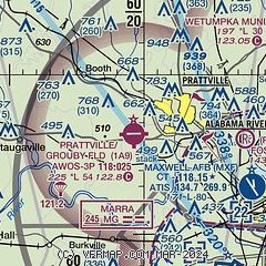
| Sectional chart |
|---|
|
| Airport distance calculator |
|---|
|
|
| Sunrise and sunset |
|---|
|
Times for 03-Jan-2026
| | Local
(UTC-6) | | Zulu
(UTC) |
|---|
| Morning civil twilight | | 06:22 | | 12:22 |
| Sunrise | | 06:49 | | 12:49 |
| Sunset | | 16:52 | | 22:52 |
| Evening civil twilight | | 17:19 | | 23:19 |
|
| Current date and time |
|---|
| Zulu (UTC) | 03-Jan-2026 12:28:54 |
|---|
| Local (UTC-6) | 03-Jan-2026 06:28:54 |
|---|
|
| METAR |
|---|
| K1A9 | 031215Z AUTO 30003KT 10SM OVC012 17/17 A2979 RMK AO2 T01710169
|
KMXF
9nm SE | 031210Z AUTO 25003KT 10SM BKN015 OVC022 18/17 A2975 RMK AO2 CIG 013V019 SLP076 $
|
KMGM
10nm SE | 031153Z AUTO 25004KT 10SM BKN014 BKN021 OVC043 18/17 A2978 RMK AO2 SLP083 60001 70006 T01780167 10194 20178 53005
|
|
| TAF |
|---|
KMGM
10nm SE | 031125Z 0312/0412 24006KT 6SM -RA BR OVC022 TEMPO 0312/0315 OVC015 FM031500 28006KT P6SM VCSH OVC008 FM031800 32008KT P6SM VCSH OVC013 FM032100 34007KT P6SM OVC018 FM040000 35005KT P6SM BKN020 FM040600 VRB03KT P6SM BKN019
|
|
| NOTAMs |
|---|
NOTAMs are issued by the DoD/FAA and will open in a separate window not controlled by AirNav.
|
|

