FAA INFORMATION EFFECTIVE 14 MAY 2026
Location
| FAA Identifier: | 20N |
| Lat/Long: | 41-59-06.9000N 073-57-51.6000W
41-59.115000N 073-57.860000W
41.9852500,-73.9643333
(estimated) |
| Elevation: | 147.4 ft. / 44.9 m (surveyed) |
| Variation: | 13W (1985) |
| From city: | 4 miles N of KINGSTON, NY |
| Time zone: | UTC -4 (UTC -5 during Standard Time) |
| Zip code: | 12401 |
Airport Operations
| Airport use: | Open to the public |
| Activation date: | 09/1961 |
| Control tower: | no |
| ARTCC: | NEW YORK CENTER |
| FSS: | NEW YORK FLIGHT SERVICE STATION |
| NOTAMs facility: | ISP (NOTAM-D service available) |
| Attendance: | JAN-DEC 0900-1700
UNATNDD THANKSGIVING AND CHRISTMAS. |
| Wind indicator: | lighted |
| Segmented circle: | yes |
| Lights: | ACTVT PAPI RYS 15 & 33 - 123.3. MIRL RY 15/33; REIL RY 33 & TWY LGTS OPERATE 123.3 DUSK-DAWN. |
| Landing fee: | yes |
Airport Communications
| CTAF/UNICOM: | 122.8 |
| NEW YORK APPROACH: | 132.75 |
| NEW YORK DEPARTURE: | 132.75 |
Nearby radio navigation aids
| VOR radial/distance | | VOR name | | Freq | | Var |
|---|
| IGNr354/20.2 | | KINGSTON VOR/DME | | 117.60 | | 12W |
| PWLr321/20.8 | | PAWLING VOR/DME | | 114.30 | | 12W |
| NDB name | | Hdg/Dist | | Freq | | Var | | ID |
|---|
| STANWYCK | | 019/27.7 | | 261 | | 12W | | SKU | ... -.- ..- |
Airport Services
| Fuel available: | 100LL JET-A |
| Parking: | tiedowns |
| Airframe service: | MAJOR |
| Powerplant service: | MAJOR |
| Bottled oxygen: | NONE |
| Bulk oxygen: | NONE |
Runway Information
Runway 15/33
| Dimensions: | 3100 x 60 ft. / 945 x 18 m |
| Surface: | asphalt, in good condition |
| Weight bearing capacity: | |
| Runway edge lights: | medium intensity |
| RUNWAY 15 | | RUNWAY 33 |
| Latitude: | 41-59.310770N | | 41-58.919070N |
| Longitude: | 073-58.078525W | | 073-57.639935W |
| Elevation: | 147.3 ft. | | 133.4 ft. |
| Traffic pattern: | left | | left |
| Runway heading: | 153 magnetic, 140 true | | 333 magnetic, 320 true |
| Displaced threshold: | 235 ft. | | 309 ft. |
| Declared distances: | TORA:3100 TODA:3100 ASDA:3010 LDA:2775 | | TORA:3100 TODA:3100 ASDA:2939 LDA:2630 |
| Markings: | nonprecision, in good condition | | nonprecision, in good condition |
| Visual slope indicator: | 2-light PAPI on left (4.50 degrees glide path)
RY 15 PAPI UNUSABLE 5 DEGS LEFT OF COURSE & 8 DEGS RIGHT OF COURSE. | | 2-light PAPI on left (3.60 degrees glide path) |
| Runway end identifier lights: | no | | yes |
| Touchdown point: | yes, no lights | | yes, no lights |
| Obstructions: | 75 ft. tree, 214 ft. from runway, 183 ft. right of centerline
RWY 15: 25 FT LIGHT POLE, 136 FT FM RWY 116 FT LEFT. 12 FENCE, 125 FT FM RWY LEFT & RIGHT. 61 FT TREE 126 FT FM RWY 181 FT LEFT. 15 FT ROAD, 135 FT FM RWY LEFT & RIGHT. | | 33 ft. pole, lighted, 257 ft. from runway, 178 ft. left of centerline, 1:1 slope to clear
RWY 33: 7 FT FENCE, 164 FT FM RWY; 8 FT SHED, 152 FT FM RWY 126 FT LEFT. |
Airport Ownership and Management from official FAA records
| Ownership: | Privately-owned |
| Owner: | KINGSTON-ULSTER ARPT INC.
1161 FLATBUSH RD
KINGSTON, NY 12401
Phone 845-336-5926 |
| Manager: | TODD COGGESHALL
1161 FLATBUSH AVE
KINGSTON, NY 12401
Phone 845-481-1559 |
Additional Remarks
| - | NO LINE OF SIGHT BTN RY 33 HOLD LINE & ACFT IN FINAL .25 MI OF APCH TO RY 33. |
| - | RENTAL CAR AVBL - 845-338-6929. |
| - | FOR CD CTC NEW YORK APCH AT 516-683-2448 |
| - | PAEW ADJACENT TWY/RWY. |
| - | VOLUNTARY NOISE ABTMT PROC IN EFCT. AVOID OVERFLIGHT OF HOUSING DEVELOPMENT ADJ TO N END OF RWY. |
| - | NO RUNUPS AT RY 15 THLD. |
Instrument Procedures
NOTE: All procedures below are presented as PDF files. If you need a reader for these files, you should download the free Adobe Reader.NOT FOR NAVIGATION. Please procure official charts for flight.
FAA instrument procedures published for use from 14 May 2026 at 0901Z to 11 June 2026 at 0900Z.
IAPs - Instrument Approach Procedures |
|---|
| RNAV (GPS) RWY 15 | |
download (203KB) |
| RNAV (GPS) RWY 33 | |
download (220KB) |
| NOTE: Special Take-Off Minimums/Departure Procedures apply | |
download (150KB) |
Other nearby airports with instrument procedures:
44N - Sky Acres Airport (19 nm SE)
1B1 - Columbia County Airport (22 nm NE)
KPOU - Hudson Valley Regional Airport (22 nm S)
N89 - Joseph Y Resnick Airport (24 nm SW)
KGBR - Great Barrington Airport (28 nm NE)
|
|

Road maps at:
MapQuest
Bing
Google
| Aerial photo |
|---|
WARNING: Photo may not be current or correct
 Photo by Karl Swenson
Photo taken 07-Aug-2010
Rwy 33 Bottom
Photo by Karl Swenson
Photo taken 07-Aug-2010
Rwy 33 Bottom
Rwy 15 Top
Do you have a better or more recent aerial photo of Kingston-Ulster Airport that you would like to share? If so, please send us your photo.
|
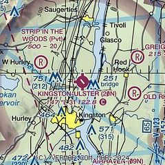
| Sectional chart |
|---|
|
CAUTION: Diagram may not be current

| Airport distance calculator |
|---|
|
|
| Sunrise and sunset |
|---|
|
Times for 01-Jun-2026
| | Local
(UTC-4) | | Zulu
(UTC) |
|---|
| Morning civil twilight | | 04:50 | | 08:50 |
| Sunrise | | 05:24 | | 09:24 |
| Sunset | | 20:24 | | 00:24 |
| Evening civil twilight | | 20:57 | | 00:57 |
|
| Current date and time |
|---|
| Zulu (UTC) | 01-Jun-2026 12:50:22 |
|---|
| Local (UTC-4) | 01-Jun-2026 08:50:22 |
|---|
|
| TAF |
|---|
KPOU
21nm S | 011133Z 0112/0212 00000KT P6SM SKC FM011600 02009KT P6SM FEW030 FM020200 VRB03KT P6SM SKC FM020700 00000KT P6SM FEW005
|
|
| NOTAMs |
|---|
NOTAMs are issued by the DoD/FAA and will open in a separate window not controlled by AirNav.
|
|


