FAA INFORMATION EFFECTIVE 16 APRIL 2026
Location
| FAA Identifier: | N89 |
| Lat/Long: | 41-43-43.9890N 074-22-36.5660W
41-43.733150N 074-22.609433W
41.7288858,-74.3768239
(estimated) |
| Elevation: | 290.2 ft. / 88.5 m (surveyed) |
| Variation: | 14W (2000) |
| From city: | 1 mile NE of ELLENVILLE, NY |
| Time zone: | UTC -4 (UTC -5 during Standard Time) |
| Zip code: | 12458 |
Airport Operations
| Airport use: | Open to the public |
| Control tower: | no |
| ARTCC: | NEW YORK CENTER |
| FSS: | NEW YORK FLIGHT SERVICE STATION |
| NOTAMs facility: | ISP (NOTAM-D service available) |
| Attendance: | 0800-DARK |
| Wind indicator: | lighted |
| Segmented circle: | yes |
| Lights: | ACTVT REIL RWY 04 & 22; PAPI RWY 04 & 22; MIRL RWY 04/22 - CTAF. |
| Beacon: | white-green (lighted land airport)
Operates sunset to sunrise. |
Airport Communications
| CTAF/UNICOM: | 122.8 |
| NEW YORK APPROACH: | 132.75 |
| NEW YORK DEPARTURE: | 132.75 |
| WX ASOS at MGJ (14 nm S): | 119.275 (845-457-1486) |
| WX AWOS-3PT at MSV (19 nm W): | 124.725 (845-583-5056) |
Nearby radio navigation aids
| VOR radial/distance | | VOR name | | Freq | | Var |
|---|
| HUOr038/21.4 | | HUGUENOT VOR/DME | | 116.10 | | 11W |
| IGNr291/25.1 | | KINGSTON VOR/DME | | 117.60 | | 12W |
| PWLr278/34.8 | | PAWLING VOR/DME | | 114.30 | | 12W |
| DNYr147/37.4 | | DELANCEY VOR/DME | | 112.10 | | 11W |
| NDB name | | Hdg/Dist | | Freq | | Var | | ID |
|---|
| STANWYCK | | 321/19.2 | | 261 | | 12W | | SKU | ... -.- ..- |
Airport Services
| Fuel available: | 100LL |
| Parking: | hangars and tiedowns |
| Airframe service: | MINOR |
| Powerplant service: | MINOR |
| Bottled oxygen: | NONE |
| Bulk oxygen: | NONE |
Runway Information
Runway 4/22
| Dimensions: | 3839 x 75 ft. / 1170 x 23 m |
| Surface: | asphalt, in good condition |
| Runway edge lights: | medium intensity |
| RUNWAY 4 | | RUNWAY 22 |
| Latitude: | 41-43.468480N | | 41-43.997812N |
| Longitude: | 074-22.840013W | | 074-22.378815W |
| Elevation: | 290.0 ft. | | 283.3 ft. |
| Traffic pattern: | left | | right |
| Runway heading: | 047 magnetic, 033 true | | 227 magnetic, 213 true |
| Displaced threshold: | no | | 309 ft. |
| Declared distances: | TORA:3838 TODA:3838 ASDA:3838 LDA:3538 | | TORA:3838 TODA:3838 ASDA:3838 LDA:3538 |
| Markings: | nonprecision, in good condition | | nonprecision, in good condition |
| Visual slope indicator: | 2-light PAPI on left (3.50 degrees glide path) | | 2-light PAPI on left (3.00 degrees glide path) |
| Runway end identifier lights: | yes | | yes |
| Touchdown point: | yes, no lights | | yes, no lights |
| Obstructions: | 109 ft. trees, 336 ft. from runway, 236 ft. left of centerline, 1:1 slope to clear
RWY 04 65 FT TREES, 0 FT FM RWY THLD, 206 FT RIGHT. | | none
RY 22 +35-55 FT TREES, 0-80 FT FROM RY THRESHOLD, 90-200 FT LEFT OF CNTRLN; -6 FT CREEK 0B 50 FT FROM THRESHOLD; +8 FT FENCE CROSSES RUNWAY 24 FT FROM THRESHOLD. |
Airport Ownership and Management from official FAA records
| Ownership: | Publicly-owned |
| Owner: | TOWN OF WAWARSING
108 CANAL STREET
ELLENVILLE, NY 12428
Phone 845-647-6570 |
| Manager: | TERRY HOUCK
TOWN SUPERVISOR, 108 CANAL STREET
ELLENVILLE, NY 12428
Phone 845-647-7800 |
Additional Remarks
| - | AVOID OVERFLIGHT OF SCHOOL & VILLAGE WHEN TAKING OFF RWY 22 OR APCH TO RWY 4, HEL OPNS FOLLOW FIXED WING FLT PAT. |
| - | FOR CD CTC NEW YORK APCH AT 516-683-2448 |
| - | COLD TEMPERATURE AIRPORT. ALTITUDE CORRECTION REQUIRED AT OR BELOW -5C. |
| - | AVOID OVERFLIGHT OF HOSP & SCHOOL BUILDINGS APPROX 1 MILE SW OF RWY 22 & PRISON APPROX 1/2 MILE NE OF ARPT. |
| - | RWY 04; 60 FT TREES 200 FT FM RWY, 191 RIGHT. |
| - | RWY 22; 8 FT FENCE CROSSES RWY 24 FT FM THR. |
| - | AWOS FREQUENCY 122.8 - 5 CLICKS. |
Instrument Procedures
NOTE: All procedures below are presented as PDF files. If you need a reader for these files, you should download the free Adobe Reader.NOT FOR NAVIGATION. Please procure official charts for flight.
FAA instrument procedures published for use from 16 April 2026 at 0901Z to 14 May 2026 at 0900Z.
IAPs - Instrument Approach Procedures |
|---|
| RNAV (GPS) RWY 04 | |
download (209KB) |
| RNAV (GPS) RWY 22 | |
download (207KB) |
| NOTE: Special Take-Off Minimums/Departure Procedures apply | |
download (458KB) |
Other nearby airports with instrument procedures:
N82 - Wurtsboro/Sullivan County Airport (9 nm SW)
KMGJ - Orange County Airport (14 nm S)
06N - Randall Airport (18 nm S)
KSWF - New York Stewart International Airport (18 nm SE)
KMSV - Sullivan County International Airport (19 nm W)
|
|

Road maps at:
MapQuest
Bing
Google
| Aerial photo |
|---|
WARNING: Photo may not be current or correct
 Photo by Kevin Kupferschmid
Photo taken 13-Sep-2017
looking north-northeast.
Photo by Kevin Kupferschmid
Photo taken 13-Sep-2017
looking north-northeast.
Do you have a better or more recent aerial photo of Joseph Y Resnick Airport that you would like to share? If so, please send us your photo.
|
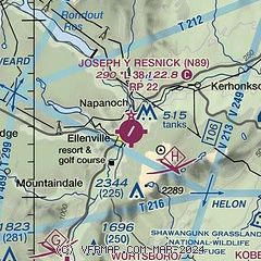
| Sectional chart |
|---|
|
| Airport distance calculator |
|---|
|
|
| Sunrise and sunset |
|---|
|
Times for 02-May-2026
| | Local
(UTC-4) | | Zulu
(UTC) |
|---|
| Morning civil twilight | | 05:23 | | 09:23 |
| Sunrise | | 05:54 | | 09:54 |
| Sunset | | 19:55 | | 23:55 |
| Evening civil twilight | | 20:26 | | 00:26 |
|
| Current date and time |
|---|
| Zulu (UTC) | 02-May-2026 16:15:45 |
|---|
| Local (UTC-4) | 02-May-2026 12:15:45 |
|---|
|
| METAR |
|---|
KMSV
18nm W | 021556Z AUTO 31011G17KT 10SM FEW049 11/M02 A2989 RMK AO2 SLP125 T01111022 PNO $
|
KSWF
19nm SE | 021545Z 04007KT 10SM SCT025 BKN040 11/07 A2988
|
KPOU
23nm E | 021601Z 07006KT 10SM SCT012 BKN017 OVC042 09/07 A2989 RMK AO2 T00940067
|
|
| TAF |
|---|
KSWF
19nm SE | 021424Z 0214/0318 30008KT P6SM SCT025 OVC080 FM021700 31009KT P6SM SCT035 BKN060 FM022300 32008KT P6SM SCT060 BKN120 BKN250 FM030200 VRB05KT P6SM FEW060 SCT120 BKN250 FM031100 30011KT P6SM FEW060 FEW120 SCT250 FM031300 31014G24KT P6SM FEW060 FEW120 SCT250 AMD NOT SKED
|
KPOU
23nm E | 021406Z 0214/0312 31005KT P6SM FEW015 BKN040 TEMPO 0214/0215 3SM -SHRA BR BKN015 OVC035 FM021800 30007KT P6SM BKN050 FM030000 33004KT P6SM FEW070 BKN250
|
|
| NOTAMs |
|---|
NOTAMs are issued by the DoD/FAA and will open in a separate window not controlled by AirNav.
|
|

