FAA INFORMATION EFFECTIVE 09 JULY 2026
Location
| FAA Identifier: | POU |
| Lat/Long: | 41-37-35.7060N 073-53-03.0790W
41-37.595100N 073-53.051317W
41.6265850,-73.8841886
(estimated) |
| Elevation: | 163.5 ft. / 49.8 m (surveyed) |
| Variation: | 12W (1975) |
| From city: | 4 miles S of POUGHKEEPSIE, NY |
| Time zone: | UTC -4 (UTC -5 during Standard Time) |
| Zip code: | 12590 |
Airport Operations
| Airport use: | Open to the public |
| Activation date: | 04/1941 |
| Control tower: | yes |
| ARTCC: | NEW YORK CENTER |
| FSS: | NEW YORK FLIGHT SERVICE STATION |
| NOTAMs facility: | POU (NOTAM-D service available) |
| Attendance: | 0700-2130 |
| Pattern altitude: | TPA SMALL ACFT 1034 FT, LARGE ACFT 1834 FT. |
| Wind indicator: | lighted |
| Segmented circle: | no |
| Lights: | WHEN ATCT CLSD ACTVT MALSR RWY 06; REIL RWY 24; HIRL RWY 06/24 - CTAF. |
| Beacon: | white-green (lighted land airport)
Operates sunset to sunrise. |
| Landing fee: | yes, LANDING FEE FOR MULTI-ENGINE AIRCRAFT. |
| Fire and rescue: | ARFF index A |
| Airline operations: | PPR 24 HRS FOR ACR OPS WITH MORE THAN 30 PAX SEATS; CALL AMGR 845-463-6000. INDEX B COVERAGE IS PRVDD. |
Airport Communications
| CTAF: | 124.0 |
| UNICOM: | 122.95 |
| ATIS: | 126.75 |
| WX ASOS: | 126.75 (845-836-6748) |
| DUTCHESS COUNTY GROUND: | 121.8 [0700-2200 (15 MAY-14 SEP); 0700-2100 (15 SEP- 14 MAY)] |
| DUTCHESS COUNTY TOWER: | 124.0 269.15 [0700-2200 (15 MAY-14 SEP); 0700-2100 (15 SEP- 14 MAY)] |
| NEW YORK APPROACH: | 132.75 |
| NEW YORK DEPARTURE: | 132.75 |
| CLEARANCE DELIVERY: | 121.8 |
| TRESA STAR: | 132.75 |
| WX ASOS at MGJ (18 nm W): | 119.275 (845-990-2308) |
Nearby radio navigation aids
| VOR radial/distance | | VOR name | | Freq | | Var |
|---|
| IGNr242/3.6 | | KINGSTON VOR/DME | | 117.60 | | 12W |
| PWLr248/15.3 | | PAWLING VOR/DME | | 114.30 | | 12W |
| CMKr339/24.9 | | CARMEL VOR/DME | | 116.60 | | 12W |
| HUOr079/34.3 | | HUGUENOT VOR/DME | | 116.10 | | 11W |
| NDB name | | Hdg/Dist | | Freq | | Var | | ID |
|---|
| STANWYCK | | 063/9.3 | | 261 | | 12W | | SKU | ... -.- ..- |
Airport Services
| Fuel available: | 100LL JET-A |
| Parking: | hangars and tiedowns |
| Airframe service: | MAJOR |
| Powerplant service: | MAJOR |
Runway Information
Runway 6/24
| Dimensions: | 5001 x 100 ft. / 1524 x 30 m |
| Surface: | asphalt/grooved, in excellent condition |
| Runway edge lights: | high intensity |
| RUNWAY 6 | | RUNWAY 24 |
| Latitude: | 41-37.315082N | | 41-37.835772N |
| Longitude: | 073-53.520042W | | 073-52.669827W |
| Elevation: | 146.6 ft. | | 154.8 ft. |
| Traffic pattern: | left | | left |
| Runway heading: | 063 magnetic, 051 true | | 243 magnetic, 231 true |
| Displaced threshold: | no | | 115 ft. |
| Declared distances: | TORA:5001 TODA:5001 ASDA:5001 LDA:5001 | | TORA:5001 TODA:5001 ASDA:5001 LDA:4886 |
| Markings: | precision, in good condition | | nonprecision, in good condition |
| Visual slope indicator: | 4-light PAPI on left (3.00 degrees glide path) | | 4-light PAPI on left (3.42 degrees glide path) |
| Approach lights: | MALSR: 1,400 foot medium intensity approach lighting system with runway alignment indicator lights | | |
| Runway end identifier lights: | | | yes |
| Touchdown point: | yes, no lights | | yes, no lights |
| Instrument approach: | ILS | | |
| Obstructions: | 18 ft. tree, 380 ft. from runway, 300 ft. left of centerline, 10:1 slope to clear | | 71 ft. tree, lighted, 210 ft. from runway, 400 ft. left of centerline
APCH SLP 4:1 TO DTHR. |
Runway 15/33
| Dimensions: | 2743 x 100 ft. / 836 x 30 m |
| Surface: | asphalt/concrete, in good condition |
| Weight bearing capacity: | | PCN 26 /F/D/W/T | | Single wheel: | 35.0 | | Double wheel: | 45.0 | | Double tandem: | 80.0 |
|
| Runway edge lights: | medium intensity |
| Operational restrictions: | RWY 15/33 NOT AVBL FOR PART 121/PART 380 OPS WITH SKED PAX CARRYING OPS MORE THAN 9 PAX SEATS AND NON-SKED PAX CARRYING OPS MORE THAN 30 PAX SEATS. NO PART 121/PART 380 OPS EXC FOR TAX. |
| RUNWAY 15 | | RUNWAY 33 |
| Latitude: | 41-37.813312N | | 41-37.474080N |
| Longitude: | 073-53.109225W | | 073-52.711690W |
| Elevation: | 155.6 ft. | | 163.5 ft. |
| Traffic pattern: | left | | left |
| Runway heading: | 151 magnetic, 139 true | | 331 magnetic, 319 true |
| Declared distances: | TORA:2743 TODA:2743 ASDA:2743 LDA:2743 | | TORA:2743 TODA:2743 ASDA:2743 LDA:2743 |
| Markings: | basic, in good condition | | basic, in good condition |
| Visual slope indicator: | | | 4-box VASI on left (3.75 degrees glide path)
VASI RSTD TO CAT A ACFT ONLY. |
| Runway end identifier lights: | | | yes |
| Touchdown point: | yes, no lights | | yes, no lights |
| Obstructions: | 51 ft. trees, 900 ft. from runway, 100 ft. right of centerline, 13:1 slope to clear | | 37 ft. trees, 240 ft. from runway, 200 ft. left of centerline, 1:1 slope to clear
+13 FT OBSTRUCTION LGTD POLE 160 FT FM THLD 150 FT LEFT. |
Runway 7/25
| Dimensions: | 1357 x 100 ft. / 414 x 30 m |
| Surface: | turf, in good condition |
| Operational restrictions: | CLSD NGTS, DURG IMC, & FM NOV 1 - APR 15. |
| RUNWAY 7 | | RUNWAY 25 |
| Latitude: | 41-37.498668N | | 41-37.639885N |
| Longitude: | 073-53.290618W | | 073-53.059823W |
| Elevation: | 151.7 ft. | | 153.4 ft. |
| Traffic pattern: | left | | left |
| Runway heading: | 063 magnetic, 051 true | | 243 magnetic, 231 true |
| Touchdown point: | yes, no lights | | yes, no lights |
| Obstructions: | none | | 24 ft. ant, marked and lighted, 215 ft. from runway, 90 ft. right of centerline, 8:1 slope to clear |
Airport Ownership and Management from official FAA records
| Ownership: | Publicly-owned |
| Owner: | DUTCHESS COUNTY
22 MARKET ST
POUGHKEEPSIE, NY 12601
Phone 845-486-2000 |
| Manager: | JEFF DURAND
263 NEW HACKENSACK RD
WAPPINGERS FALLS, NY 12590
Phone 845-463-6000 |
Additional Remarks
| A39-06/24 | PCR VALUE: 396/F/C/X/T |
| - | CTC FBO DURG BUS HRS AT 845-849-3770 FOR AFT HRS FUEL SVC. |
| - | TWY C, TWY G T-HNGR TXL, & TWY J T-HNGR TXL CLSD TO ACR ACFT. |
| - | FOR CD WHEN ATCT CLSD CTC NEW YORK APCH AT 516-683-2448 OR 121.8. |
| - | RWY 06 TGL AND PRACTICE APCHS PROHIBITED DUE TO OBSCD LINE OF SIGHT FM ATCT. |
| - | RWY 15/33 CLSD TO SKED ACR OPS WITH MORE THAN 9 PAX SEATS AND NON SKED ACR OPS WITH MORE THAN 30 PAX SEATS EXCP FOR TAXI. |
| - | NEW NOISE ABATEMENT: REPETITIVE OPNS PROHIBITED WHEN ATCT CLSD. |
| - | NOISE ABATEMENT PROCEDURES IN EFCT CTC AMGR FOR DETAILS. |
| - | BIRDS & DEER ON & INVOF ARPT. |
| - | RWY 07/25 RESTRICTED TO ACFT LESS THAN 12500 LBS. |
Instrument Procedures
NOTE: All procedures below are presented as PDF files. If you need a reader for these files, you should download the free Adobe Reader.NOT FOR NAVIGATION. Please procure official charts for flight.
FAA instrument procedures published for use from 09 July 2026 at 0901Z to 06 August 2026 at 0900Z.
STARs - Standard Terminal Arrivals |
|---|
| TRESA TWO (RNAV) **NEW** | |
download (126KB) |
IAPs - Instrument Approach Procedures |
|---|
| ILS OR LOC RWY 06 | |
download (317KB) |
| RNAV (GPS) RWY 06 | |
download (322KB) |
| RNAV (GPS) RWY 24 | |
download (245KB) |
| VOR RWY 24 | |
download (261KB) |
| VOR-A | |
download (214KB) |
| NOTE: Special Alternate Minimums apply | |
download (122KB) |
Departure Procedures |
|---|
| DUTCHESS EIGHT | |
download (289KB) |
| NOTE: Special Take-Off Minimums/Departure Procedures apply | |
download (283KB) |
Other nearby airports with instrument procedures:
44N - Sky Acres Airport (8 nm NE)
KSWF - New York Stewart International Airport (12 nm SW)
KMGJ - Orange County Airport (18 nm W)
20N - Kingston-Ulster Airport (22 nm N)
N89 - Joseph Y Resnick Airport (23 nm W)
|
|

Road maps at:
MapQuest
Bing
Google
| Aerial photo |
|---|
WARNING: Photo may not be current or correct
 Photo by Eve Cascella
Photo taken 11-Oct-2008
from the south looking north
Photo by Eve Cascella
Photo taken 11-Oct-2008
from the south looking north
Do you have a better or more recent aerial photo of Hudson Valley Regional Airport that you would like to share? If so, please send us your photo.
|
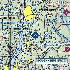
| Sectional chart |
|---|
|
CAUTION: Diagram may not be current
 Download PDF
of official airport diagram from the FAA
| Airport distance calculator |
|---|
|
|
| Sunrise and sunset |
|---|
|
Times for 02-Aug-2026
| | Local
(UTC-4) | | Zulu
(UTC) |
|---|
| Morning civil twilight | | 05:21 | | 09:21 |
| Sunrise | | 05:52 | | 09:52 |
| Sunset | | 20:12 | | 00:12 |
| Evening civil twilight | | 20:43 | | 00:43 |
|
| Current date and time |
|---|
| Zulu (UTC) | 02-Aug-2026 15:25:18 |
|---|
| Local (UTC-4) | 02-Aug-2026 11:25:18 |
|---|
|
| METAR |
|---|
| KPOU | 021453Z VRB04G15KT 10SM SCT028 BKN035 BKN049 28/21 A2994 RMK AO2 SLP133 T02780211 56005
|
KSWF
12nm SW | 021445Z 18010G15KT 10SM SCT030 BKN070 26/21 A2995
|
KMGJ
18nm W | SuperAWOS
021454Z AUTO 19010G17KT 10SM SCT026 SCT030 27/21 A2994 RMK AO2 SLP137 T02720211 56005
|
|
| TAF |
|---|
| KPOU | 021120Z 0212/0312 17007G15KT P6SM SCT015 BKN035 OVC150 FM021700 16009G18KT P6SM BKN035 OVC150 FM030000 14004KT P6SM VCSH BKN025 OVC150 TEMPO 0303/0305 5SM -SHRA BR FM030500 15006KT 3SM -RA BR BKN008 OVC020
|
KSWF
12nm SW | 021140Z 0212/0318 18005KT P6SM FEW070 BKN200 FM021500 17009G18KT P6SM SCT025 BKN100 FM022100 15009KT P6SM SCT025 BKN050 PROB30 0222/0303 5SM -SHRA BR BKN025 FM030300 13005KT 5SM -SHRA BR SCT009 OVC012 FM030600 17007KT 3SM SHRA BR OVC007 FM030900 21007KT 3SM -SHRA BR BKN007 OVC012 TEMPO 0309/0313 2SM TSRA BR SCT007 OVC012CB FM031600 23010G18KT 5SM -SHRA BR SCT015 BKN025 AMD NOT SKED
|
|
| NOTAMs |
|---|
NOTAMs are issued by the DoD/FAA and will open in a separate window not controlled by AirNav.
|
|


