FAA INFORMATION EFFECTIVE 14 MAY 2026
Location
| FAA Identifier: | 27C |
| Lat/Long: | 43-37-48.1667N 085-15-41.3617W
43-37.802778N 085-15.689362W
43.6300463,-85.2614894
(estimated) |
| Elevation: | 1022 ft. / 312 m (estimated) |
| From city: | 2 miles W of MECOSTA, MI |
| Time zone: | UTC -4 (UTC -5 during Standard Time) |
| Zip code: | 49332 |
Airport Operations
| Airport use: | Open to the public |
| Activation date: | 10/1950 |
| Control tower: | no |
| ARTCC: | MINNEAPOLIS CENTER |
| FSS: | LANSING FLIGHT SERVICE STATION |
| NOTAMs facility: | LAN (NOTAM-D service available) |
| Attendance: | UNATNDD |
| Wind indicator: | yes |
| Segmented circle: | yes |
Airport Communications
| CTAF: | 122.9 |
| WX AWOS-3P at RQB (12 nm NW): | 125.875 (231-796-0884) |
Nearby radio navigation aids
| VOR radial/distance | | VOR name | | Freq | | Var |
|---|
| MOPr276/22.8 | | MOUNT PLEASANT VOR/DME | | 110.60 | | 05W |
Airport Services
| Airframe service: | NONE |
| Powerplant service: | NONE |
| Bottled oxygen: | NONE |
| Bulk oxygen: | NONE |
Runway Information
Runway 9/27
| Dimensions: | 2027 x 100 ft. / 618 x 30 m |
| Surface: | turf, in fair condition |
| Runway edge markings: | RWY MKD WITH 18 IN YELLOW CONES. |
| RUNWAY 9 | | RUNWAY 27 |
| Latitude: | 43-37.819500N | | 43-37.838500N |
| Longitude: | 085-15.885833W | | 085-15.427500W |
| Elevation: | 1020.0 ft. | | 1018.0 ft. |
| Traffic pattern: | left | | left |
| Runway heading: | 087 true | | 267 true |
| Displaced threshold: | 546 ft. | | no |
| Runway end identifier lights: | no | | no |
| Obstructions: | 15 ft. road, 38 ft. from runway, 2:1 slope to clear
APCH RATIO 13:1 AT DTHR OVR 62 FT TREE, 860 FT DIST, 130 FT R; 20:1 BASED ON STRAIGHT OUT. | | 8 ft. tree, 110 ft. left of centerline
APCH RATIO 20:1 BASED ON STRAIGHT OUT OVR 38 FT TREES, 773 FT DIST, 0 FT B. |
Runway 3/21
| Dimensions: | 2010 x 100 ft. / 613 x 30 m |
| Surface: | turf, in fair condition |
| Runway edge markings: | RWY & DTHR MKD WITH 18 IN YELLOW CONES. |
| RUNWAY 3 | | RUNWAY 21 |
| Latitude: | 43-37.639333N | | 43-37.913333N |
| Longitude: | 085-15.850167W | | 085-15.594500W |
| Elevation: | 1011.0 ft. | | 1013.0 ft. |
| Traffic pattern: | left | | left |
| Runway heading: | 034 true | | 214 true |
| Displaced threshold: | 750 ft. | | 810 ft. |
| Obstructions: | 17 ft. road, 100 ft. from runway, 135 ft. right of centerline, 5:1 slope to clear
APCH RATIO 20:1 AT DTHR OVR 91 FT TREES, 1820 FT DIST, 0 FT B. | | 30 ft. trees, 115 ft. right of centerline
APCH RATIO 5:1 AT DTHR OVR 54 FT TREE, 273 FT DIST, 125 FT L; 17:1 BASED ON STRAIGHT OUT OVR 58 FT TREE, 1034 FT DIST, 45 FT R. |
Airport Ownership and Management from official FAA records
| Ownership: | Publicly-owned |
| Owner: | MECOSTA VILLAGE/MORTON TWP
PO BOX 387, 115 MAIN ST
MECOSTA, MI 49332-0387
Phone 231-972-7614 |
| Manager: | TREVER WALBURG
10964 90TH AVE
MECOSTA, MI 49332-9739
Phone 231-972-8880 |
Additional Remarks
| - | NO SNOW REMOVAL. |
| - | UAS OPR ON RWY 09/27 E OF RWY 03/21 INT. |
| - | FOR CD CTC MINNEAPOLIS ARTCC AT 651-463-5588. |
Instrument Procedures
There are no published instrument procedures at 27C.
Some nearby airports with instrument procedures:
13C - Lakeview Airport/Griffith Field (11 nm S)
KRQB - Roben-Hood Airport (12 nm NW)
KMOP - Mount Pleasant Municipal Airport (23 nm E)
48D - Clare Municipal Airport (26 nm NE)
7D3 - Baldwin Municipal Airport (29 nm NW)
|
|

Road maps at:
MapQuest
Bing
Google
| Aerial photo |
|---|

|
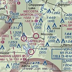
| Sectional chart |
|---|
|
| Airport distance calculator |
|---|
|
|
| Sunrise and sunset |
|---|
|
Times for 31-May-2026
| | Local
(UTC-4) | | Zulu
(UTC) |
|---|
| Morning civil twilight | | 05:29 | | 09:29 |
| Sunrise | | 06:04 | | 10:04 |
| Sunset | | 21:13 | | 01:13 |
| Evening civil twilight | | 21:48 | | 01:48 |
|
| Current date and time |
|---|
| Zulu (UTC) | 31-May-2026 08:04:42 |
|---|
| Local (UTC-4) | 31-May-2026 04:04:42 |
|---|
|
| METAR |
|---|
KRQB
12nm NW | 310755Z AUTO 35001KT 10SM CLR 05/03 A3021 RMK AO2
|
KMOP
23nm E | 310755Z AUTO 00000KT 10SM CLR 06/05 A3022 RMK AO2 T00560053
|
|
| TAF |
|---|
KGRR
46nm S | 310520Z 3106/0106 08005KT P6SM BKN250 FM311200 12007KT P6SM SCT250 FM311600 VRB05KT P6SM SCT250 FM010000 33004KT P6SM SCT200
|
|
| NOTAMs |
|---|
NOTAMs are issued by the DoD/FAA and will open in a separate window not controlled by AirNav.
|
|

