FAA INFORMATION EFFECTIVE 09 JULY 2026
Location
| FAA Identifier: | 2F6 |
| Lat/Long: | 36-21-18.5190N 096-00-38.6122W
36-21.308650N 096-00.643537W
36.3551442,-96.0107256
(estimated) |
| Elevation: | 671.2 ft. / 204.6 m (surveyed) |
| Variation: | 06E (1985) |
| From city: | 1 mile SW of SKIATOOK, OK |
| Time zone: | UTC -5 (UTC -6 during Standard Time) |
| Zip code: | 74070 |
Airport Operations
| Airport use: | Open to the public |
| Activation date: | 12/1970 |
| Control tower: | no |
| ARTCC: | KANSAS CITY CENTER |
| FSS: | MC ALESTER FLIGHT SERVICE STATION |
| NOTAMs facility: | MLC (NOTAM-D service available) |
| Attendance: | UNATNDD |
| Wind indicator: | lighted |
| Segmented circle: | yes |
| Lights: | ACTVT MIRL RWY 18/36 - CTAF. PAPI RWY 18 ON CONSLY. |
| Beacon: | white-green (lighted land airport)
Operates sunset to sunrise. |
Airport Communications
| CTAF/UNICOM: | 122.8 |
| WX ASOS at TUL (11 nm SE): | PHONE 539-399-0187 |
| WX AWOS-3T at OWP (13 nm SW): | 118.325 (918-246-2635) |
| WX ASOS at RVS (19 nm S): | 126.5 (918-299-0740) |
Nearby radio navigation aids
| VOR radial/distance | | VOR name | | Freq | | Var |
|---|
| TULr304/14.4 | | TULSA VORTAC | | 114.40 | | 08E |
| BVOr171/28.8 | | BARTLESVILLE VOR/DME | | 117.90 | | 08E |
Airport Services
| Fuel available: | 100LL
100LL:FUEL AVBL 24 HR WITH CREDIT CARD ADP SYS. |
| Parking: | hangars and tiedowns |
| Airframe service: | NONE |
| Powerplant service: | NONE |
| Bottled oxygen: | NONE |
| Bulk oxygen: | NONE |
Runway Information
Runway 18/36
| Dimensions: | 3002 x 60 ft. / 915 x 18 m |
| Surface: | concrete, in good condition |
| Weight bearing capacity: | | Single wheel: | 4.0, SPONSOR IMPOSED. |
|
| Runway edge lights: | medium intensity |
| RUNWAY 18 | | RUNWAY 36 |
| Latitude: | 36-21.565305N | | 36-21.070588N |
| Longitude: | 096-00.660850W | | 096-00.665692W |
| Elevation: | 668.8 ft. | | 655.5 ft. |
| Traffic pattern: | left | | left |
| Runway heading: | 174 magnetic, 180 true | | 354 magnetic, 000 true |
| Displaced threshold: | no | | 90 ft. |
| Markings: | basic, in good condition | | basic, in good condition |
| Visual slope indicator: | 2-light PAPI on left (3.00 degrees glide path) | | PAPI UNUSBL. |
| Touchdown point: | yes, no lights | | yes, no lights |
| Obstructions: | none
RWY 36 20 FT TREE 302 FT FM THLD, 8 FT LEFT; APCH SLOPE TO DTHR 19:1. | | 25 ft. tree, 236 ft. from runway, 77 ft. left of centerline, 1:1 slope to clear
22 FT TREE 199 FT FM RWY 36 END 115 FT RIGHT OF EXTDD CNTRLN. |
Runway N/S
| Dimensions: | 2600 x 40 ft. / 792 x 12 m
TURF RY CLSD INDEFLY. |
| Surface: | turf, in fair condition |
| RUNWAY N | | RUNWAY S |
| Latitude: | 36-21.083667N | | 36-21.512167N |
| Longitude: | 096-00.623000W | | 096-00.618500W |
| Elevation: | 650.0 ft. | | 650.0 ft. |
| Traffic pattern: | left | | left |
| Runway heading: | 354 magnetic, 000 true | | 174 magnetic, 180 true |
| Obstructions: | 60 ft. tree, 1690 ft. from runway, 28:1 slope to clear | | 25 ft. tree, 390 ft. from runway, 155 ft. left of centerline, 15:1 slope to clear |
Airport Ownership and Management from official FAA records
| Ownership: | Publicly-owned |
| Owner: | CITY OF SKIATOOK
110 N. BROADWAY, PO BOX 399
SKIATOOK, OK 74070
Phone 918-396-2797 |
| Manager: | BRAD WHITE
110 N BROADWAY, PO BOX 399, PO BOX 399
SKIATOOK, OK 74070
Phone 918-396-2797 |
Additional Remarks
| - | FOR CD CTC TULSA APCH AT 918-831-6714/6720. |
Instrument Procedures
There are no published instrument procedures at 2F6.
Some nearby airports with instrument procedures:
KTUL - Tulsa International Airport (11 nm SE)
KOWP - William R Pogue Municipal Airport (13 nm SW)
KRVS - Tulsa Riverside Airport (19 nm S)
KBVO - Bartlesville Municipal Airport (24 nm N)
KGCM - Claremore Regional Airport (26 nm E)
|
|

Road maps at:
MapQuest
Bing
Google
| Aerial photo |
|---|
WARNING: Photo may not be current or correct
 Photo by Juan Felipe Arango Pérez
Photo taken 24-Aug-2011
looking southwest.
Photo by Juan Felipe Arango Pérez
Photo taken 24-Aug-2011
looking southwest.
Do you have a better or more recent aerial photo of Skiatook Municipal Airport that you would like to share? If so, please send us your photo.
|
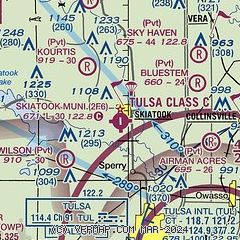
| Sectional chart |
|---|
|
| Airport distance calculator |
|---|
|
|
| Sunrise and sunset |
|---|
|
Times for 30-Jul-2026
| | Local
(UTC-5) | | Zulu
(UTC) |
|---|
| Morning civil twilight | | 06:01 | | 11:01 |
| Sunrise | | 06:30 | | 11:30 |
| Sunset | | 20:31 | | 01:31 |
| Evening civil twilight | | 20:59 | | 01:59 |
|
| Current date and time |
|---|
| Zulu (UTC) | 30-Jul-2026 20:01:50 |
|---|
| Local (UTC-5) | 30-Jul-2026 15:01:50 |
|---|
|
| METAR |
|---|
KTUL
11nm SE | 301953Z 17006KT 10SM SCT055 BKN200 35/23 A2992 RMK AO2 SLP120 T03500233
|
KOWP
13nm SW | 301955Z AUTO 21006KT 170V230 10SM SCT050 36/22 A2992 RMK AO2
|
KRVS
18nm S | 301953Z 18007KT 140V200 10SM CLR 37/23 A2991 RMK AO2 SLP128 T03720228
|
|
| TAF |
|---|
KTUL
11nm SE | 301720Z 3018/3118 16010KT P6SM SCT100 BKN150 FM310100 15009KT P6SM SCT100 BKN250 FM311500 22010KT P6SM SCT150
|
KRVS
18nm S | 301720Z 3018/3118 16009KT P6SM SCT100 BKN150 FM310100 15008KT P6SM SCT100 BKN250 FM311500 21008KT P6SM SCT150
|
|
| NOTAMs |
|---|
NOTAMs are issued by the DoD/FAA and will open in a separate window not controlled by AirNav.
|
|

