FAA INFORMATION EFFECTIVE 14 MAY 2026
Location
| FAA Identifier: | 31E |
| Lat/Long: | 39-39-55.6350N 074-18-28.9600W
39-39.927250N 074-18.482667W
39.6654542,-74.3080444
(estimated) |
| Elevation: | 38.6 ft. / 12 m (estimated) |
| Variation: | 12W (1985) |
| From city: | 2 miles N of WEST CREEK, NJ |
| Time zone: | UTC -4 (UTC -5 during Standard Time) |
| Zip code: | 08092 |
Airport Operations
| Airport use: | Open to the public |
| Activation date: | 04/1989 |
| Control tower: | no |
| ARTCC: | WASHINGTON CENTER |
| FSS: | MILLVILLE FLIGHT SERVICE STATION |
| NOTAMs facility: | MIV (NOTAM-D service available) |
| Attendance: | NOV-MAR 7 SR-SS, APR-OCT 7 0900-1700 |
| Wind indicator: | yes |
| Segmented circle: | no |
| Lights: | ACTVT PAPI RWY 14 & 32; HIRL RWY 14/32 - CTAF. |
| Beacon: | white-green (lighted land airport)
Operates sunset to sunrise. |
Airport Communications
| CTAF: | 122.9 |
| ATLANTIC CITY APPROACH: | 134.25 |
| ATLANTIC CITY DEPARTURE: | 134.25 |
| WX AWOS-3PT at MJX (16 nm N): | 119.875 (732-797-2542) |
| WX ASOS at ACY (18 nm SW): | PHONE 609-277-2644 |
Nearby radio navigation aids
| VOR radial/distance | | VOR name | | Freq | | Var |
|---|
| CYNr158/10.7 | | COYLE VORTAC | | 113.40 | | 10W |
| ACYr055/17.7 | | ATLANTIC CITY VORTAC | | 117.15 | | 10W |
| GXUr159/24.5 | | MC GUIRE VORTAC | | 110.60 | | 12W |
| VCNr086/31.4 | | CEDAR LAKE VOR/DME | | 115.20 | | 10W |
| RBVr175/33.3 | | ROBBINSVILLE VORTAC | | 113.80 | | 10W |
| COLr201/39.4 | | COLTS NECK VOR/DME | | 115.40 | | 11W |
| NDB name | | Hdg/Dist | | Freq | | Var | | ID |
|---|
| LAKEHURST | | 188/22.8 | | 396 | | 11W | | NEL | -. . .-.. |
Airport Services
| Fuel available: | 100LL |
| Parking: | tiedowns |
| Airframe service: | MAJOR |
| Powerplant service: | MAJOR |
| Bottled oxygen: | NONE |
| Bulk oxygen: | NONE |
Runway Information
Runway 14/32
| Dimensions: | 3670 x 60 ft. / 1119 x 18 m |
| Surface: | asphalt, in excellent condition |
| Runway edge lights: | high intensity |
| RUNWAY 14 | | RUNWAY 32 |
| Latitude: | 39-40.137167N | | 39-39.717333N |
| Longitude: | 074-18.764167W | | 074-18.201167W |
| Elevation: | 31.2 ft. | | 38.6 ft. |
| Traffic pattern: | left | | right |
| Runway heading: | 146 magnetic, 134 true | | 326 magnetic, 314 true |
| Displaced threshold: | 400 ft. | | 400 ft. |
| Markings: | nonprecision, in good condition | | nonprecision, in good condition |
| Visual slope indicator: | 2-light PAPI on left (4.00 degrees glide path) | | 2-light PAPI on left (4.00 degrees glide path)
PAPI UNUSABLE 5 DEG LEFT OF COURSE. |
| Touchdown point: | yes, no lights | | yes, no lights |
| Obstructions: | 58 ft. tree, 785 ft. from runway, 126 ft. right of centerline, 10:1 slope to clear | | 64 ft. tree, 484 ft. from runway, 92 ft. right of centerline, 4:1 slope to clear |
Airport Ownership and Management from official FAA records
| Ownership: | Privately-owned |
| Owner: | EAGLES NEST AIRPORT LLC
100 AIRPORT ROAD, PO BOX 129
WEST CREEK, NJ 08092
Phone 609-296-1229 |
| Manager: | SAL MAZZA
100 AIRPORT ROAD, PO BOX 129
WEST CREEK, NJ 08092
Phone 609-296-1229 |
Additional Remarks
| - | REMOTE CTL ACFT OPER ADJ TO RY. |
| - | PARACHUTE DROP ZONE SW CORNER OF ARPT |
| - | DEER ON & INVOF ARPT. |
| - | FOR CD CTC WASHINGTON ARTCC AT 703-771-3587. |
| - | BTN THE HRS OF SS-SR TAKE OFF RWY 32 ONLY, LDG RWY 14 ONLY. |
| - | SEASONAL BANNER TOWING OPNS PARL TO LEFT SIDE RWY 32. |
Instrument Procedures
NOTE: All procedures below are presented as PDF files. If you need a reader for these files, you should download the free Adobe Reader.NOT FOR NAVIGATION. Please procure official charts for flight.
FAA instrument procedures published for use from 14 May 2026 at 0901Z to 11 June 2026 at 0900Z.
IAPs - Instrument Approach Procedures |
|---|
| RNAV (GPS)-A | |
download (164KB) |
| RNAV (GPS)-B | |
download (168KB) |
| NOTE: Special Take-Off Minimums/Departure Procedures apply | |
download (249KB) |
Other nearby airports with instrument procedures:
KMJX - Ocean County Airport (16 nm N)
KACY - Atlantic City International Airport (18 nm SW)
N81 - Hammonton Municipal Airport (21 nm W)
KNEL - Lakehurst Maxfield Field Airport (22 nm N)
KWRI - McGuire Field (Joint Base Mc Guire Dix Lakehurst) Airport (25 nm NW)
|
|

Road maps at:
MapQuest
Bing
Google
| Aerial photo |
|---|
WARNING: Photo may not be current or correct
 Photo courtesy of FlyinPhilsPhotos.com
Photo taken 30-Sep-2007
looking north.
Photo courtesy of FlyinPhilsPhotos.com
Photo taken 30-Sep-2007
looking north.
Do you have a better or more recent aerial photo of Eagles Nest Airport that you would like to share? If so, please send us your photo.
|
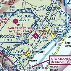
| Sectional chart |
|---|
|
| Airport distance calculator |
|---|
|
|
| Sunrise and sunset |
|---|
|
Times for 06-Jun-2026
| | Local
(UTC-4) | | Zulu
(UTC) |
|---|
| Morning civil twilight | | 04:59 | | 08:59 |
| Sunrise | | 05:31 | | 09:31 |
| Sunset | | 20:21 | | 00:21 |
| Evening civil twilight | | 20:53 | | 00:53 |
|
| Current date and time |
|---|
| Zulu (UTC) | 06-Jun-2026 09:57:10 |
|---|
| Local (UTC-4) | 06-Jun-2026 05:57:10 |
|---|
|
| METAR |
|---|
KMJX
16nm N | AWOS-3 119.875 732-244-4450
060856Z AUTO 22003KT 10SM CLR 16/13 A2993 RMK AO2 SLP139 T01610128 56007 $
|
KACY
17nm SW | 060954Z 23003KT 10SM CLR 21/15 A2994 RMK AO2 SLP139 T02060150 $
|
KWRI
25nm NW | 060855Z AUTO 23003KT 10SM CLR 19/15 A2992 RMK AO2 SLP130 T01880145 57008 $
|
KVAY
29nm NW | ASOS 119.325 609-267-1176
060954Z AUTO A2993 RMK AO2 SLPNO PWINO $
|
KBLM
31nm N | AWOS-3 121.625 732-938-3330
060856Z AUTO 22005KT 10SM CLR 21/15 A2993 RMK AO2 SLP134 6//// T02060150 58007 PNO $
|
|
| TAF |
|---|
KACY
17nm SW | 060520Z 0606/0706 22004KT P6SM SKC FM061300 25008KT P6SM FEW250 FM061600 24013G22KT P6SM FEW070 BKN250 FM062300 22007KT P6SM SCT050 BKN250 FM070400 29007KT P6SM VCSH BKN060
|
|
| NOTAMs |
|---|
NOTAMs are issued by the DoD/FAA and will open in a separate window not controlled by AirNav.
|
|

