FAA INFORMATION EFFECTIVE 14 MAY 2026
Location
| FAA Identifier: | 42B |
| Lat/Long: | 41-26-44.3560N 072-27-20.3130W
41-26.739267N 072-27.338550W
41.4456544,-72.4556425
(estimated) |
| Elevation: | 9 ft. / 3 m (estimated) |
| Variation: | 14W (1985) |
| From city: | 1 mile SE of EAST HADDAM, CT |
| Time zone: | UTC -4 (UTC -5 during Standard Time) |
| Zip code: | 06423 |
Airport Operations
| Airport use: | Open to the public |
| Activation date: | 11/1964 |
| Control tower: | no |
| ARTCC: | NEW YORK CENTER |
| FSS: | BRIDGEPORT FLIGHT SERVICE STATION |
| NOTAMs facility: | BDR (NOTAM-D service available) |
| Attendance: | UNATNDD |
| Wind indicator: | lighted |
| Segmented circle: | no |
| Lights: | ARPT LGTS OPR 24/7. |
| Landing fee: | yes, OVNGT PRKG FEE. |
Airport Communications
| CTAF/UNICOM: | 122.8 |
| WX AWOS-3 at SNC (4 nm SW): | 118.325 (860-526-1551) |
| WX ASOS at MMK (17 nm W): | 134.925 (203-639-9405) |
| WX ASOS at HFD (20 nm NW): | PHONE 860-952-9954 |
| WX ASOS at GON (20 nm E): | 127.0 (860-449-8921) |
Nearby radio navigation aids
| VOR radial/distance | | VOR name | | Freq | | Var |
|---|
| HFDr174/12.4 | | HARTFORD VOR/DME | | 114.90 | | 13W |
| MADr066/13.3 | | MADISON VOR/DME | | 110.40 | | 13W |
| GONr305/19.4 | | GROTON VOR/DME | | 110.85 | | 14W |
| ORWr266/21.6 | | NORWICH VOR/DME | | 110.00 | | 14W |
| HTOr002/32.2 | | HAMPTON VORTAC | | 113.60 | | 13W |
| CCCr040/34.6 | | CALVERTON VOR/DME | | 114.55 | | 13W |
| BDRr072/34.7 | | BRIDGEPORT VOR/DME | | 108.80 | | 12W |
Airport Services
| Parking: | tiedowns |
| Airframe service: | MAJOR |
| Powerplant service: | MAJOR |
Runway Information
Runway 14/32
| Dimensions: | 2120 x 50 ft. / 646 x 15 m |
| Surface: | asphalt, in good condition |
| Weight bearing capacity: | |
| Runway edge lights: | low intensity |
| RUNWAY 14 | | RUNWAY 32 |
| Latitude: | 41-26.886333N | | 41-26.656500N |
| Longitude: | 072-27.613167W | | 072-27.263667W |
| Traffic pattern: | left | | left |
| Markings: | basic, in fair condition | | basic, in fair condition |
| Runway end identifier lights: | no | | no |
| Obstructions: | none
+12 FT N-S ROAD AT THR. | | 70 ft. trees, 450 ft. from runway, 150 ft. left of centerline, 3:1 slope to clear |
Runway 16W/34W
| Dimensions: | 4500 x 1000 ft. / 1372 x 305 m |
| Surface: | water |
| RUNWAY 16W | | RUNWAY 34W |
| Traffic pattern: | left | | left |
| Runway end identifier lights: | no | | no |
| Obstructions: | 85 ft. bridge, lighted, 1700 ft. from runway, 20:1 slope to clear | | hill, 2500 ft. from runway, 34:1 slope to clear |
Airport Ownership and Management from official FAA records
| Ownership: | Privately-owned |
| Owner: | NEW ENGLAND AIRPORT ASSOCIATES
C/O GOODSPEED AIRPORT, P. O. BOX 216
EAST HADDAM, CT 06423 |
| Manager: | BILL MCENERY
C/O GOODSPEED AIRPORT, P. O. BOX 216
EAST HADDAM, CT 06423
Phone (860) 615-9068 |
Additional Remarks
| - | PRKG FEE. |
| - | CTN DEER, BIRDS & WATERFOWL ON & INVOF ARPT. |
| - | FOR CD CTC NEW YORK APCH AT 516-683-2449. |
| - | PARL TURF TWY MKD WITH YELLOW CONES. MAY BE SOFT WHEN WET OR AFT RAIN. |
| - | SEAPLANE DOCK AND RAMP. |
Instrument Procedures
There are no published instrument procedures at 42B.
Some nearby airports with instrument procedures:
KSNC - Chester Airport (4 nm SW)
KMMK - Meriden Markham Municipal Airport (17 nm W)
KHFD - Hartford-Brainard Airport (20 nm NW)
KGON - Groton-New London Airport (20 nm E)
KIJD - Windham Airport (22 nm NE)
|
|

Road maps at:
MapQuest
Bing
Google
| Aerial photo |
|---|
WARNING: Photo may not be current or correct
 Taken in December 2006
Do you have a better or more recent aerial photo of Goodspeed Airport that you would like to share? If so, please send us your photo.
|
| Sectional chart |
|---|
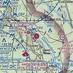
|
| Airport distance calculator |
|---|
|
|
| Sunrise and sunset |
|---|
|
Times for 26-May-2026
| | Local
(UTC-4) | | Zulu
(UTC) |
|---|
| Morning civil twilight | | 04:50 | | 08:50 |
| Sunrise | | 05:23 | | 09:23 |
| Sunset | | 20:11 | | 00:11 |
| Evening civil twilight | | 20:44 | | 00:44 |
|
| Current date and time |
|---|
| Zulu (UTC) | 27-May-2026 02:41:48 |
|---|
| Local (UTC-4) | 26-May-2026 22:41:48 |
|---|
|
| METAR |
|---|
KSNC
4nm SW | 270215Z AUTO 00000KT 10SM CLR 18/13 A3001 RMK AO2
|
KMMK
18nm W | 270153Z AUTO 00000KT 10SM CLR 19/12 A3000 RMK AO2 SLP157 T01890122
|
KHFD
19nm NW | 270153Z 16007KT 10SM CLR 20/13 A2997 RMK AO2 SLP149 T02000128
|
KGON
19nm E | 270156Z 23006KT 10SM CLR 17/13 A2999 RMK AO2 SLP156 T01670133
|
|
| TAF |
|---|
KGON
19nm E | 270210Z 2702/2724 23006KT P6SM SCT250 FM270500 24004KT P6SM BKN250 FM271300 23008KT P6SM SCT008 BKN015 FM271600 23011KT P6SM SCT035 BKN120 FM272300 28008KT P6SM SCT060
|
|
| NOTAMs |
|---|
NOTAMs are issued by the DoD/FAA and will open in a separate window not controlled by AirNav.
|
|

