FAA INFORMATION EFFECTIVE 27 NOVEMBER 2025
Location
| FAA Identifier: | 44N |
| Lat/Long: | 41-42-26.7260N 073-44-16.8810W
41-42.445433N 073-44.281350W
41.7074239,-73.7380225
(estimated) |
| Elevation: | 697.3 ft. / 212.5 m (surveyed) |
| Variation: | 14W (2000) |
| From city: | 6 miles SW of MILLBROOK, NY |
| Time zone: | UTC -5 (UTC -4 during Daylight Saving Time) |
| Zip code: | 12585 |
Airport Operations
| Airport use: | Open to the public |
| Activation date: | 06/1965 |
| Control tower: | no |
| ARTCC: | NEW YORK CENTER |
| FSS: | NEW YORK FLIGHT SERVICE STATION |
| NOTAMs facility: | ISP (NOTAM-D service available) |
| Attendance: | MON-FRI 0800-1600, ALL SAT-SUN 0800-1600 |
| Wind indicator: | lighted |
| Segmented circle: | no |
| Lights: | ACTVT PAPI RWY 35; MIRL RWY 17/35 - CTAF. |
Airport Communications
| CTAF/UNICOM: | 122.8 |
| NEW YORK APPROACH: | 132.75 |
| NEW YORK DEPARTURE: | 132.75 |
| WX ASOS at POU (8 nm SW): | 126.75 (845-462-0648) |
Nearby radio navigation aids
| VOR radial/distance | | VOR name | | Freq | | Var |
|---|
| IGNr068/4.5 | | KINGSTON VOR/DME | | 117.60 | | 12W |
| PWLr251/7.2 | | PAWLING VOR/DME | | 114.30 | | 12W |
| CMKr357/26.6 | | CARMEL VOR/DME | | 116.60 | | 12W |
| NDB name | | Hdg/Dist | | Freq | | Var | | ID |
|---|
| STANWYCK | | 064/17.5 | | 261 | | 12W | | SKU | ... -.- ..- |
Airport Services
| Fuel available: | 100LL
100LL:SELF-SVC FUEL AVBL 24/7. |
| Parking: | tiedowns |
| Airframe service: | MAJOR |
| Powerplant service: | MAJOR |
Runway Information
Runway 17/35
| Dimensions: | 3828 x 60 ft. / 1167 x 18 m |
| Surface: | asphalt, in good condition |
| Weight bearing capacity: | |
| Runway edge lights: | medium intensity |
| RUNWAY 17 | | RUNWAY 35 |
| Latitude: | 41-42.725845N | | 41-42.165030N |
| Longitude: | 073-44.473300W | | 073-44.089415W |
| Elevation: | 646.1 ft. | | 697.0 ft. |
| Traffic pattern: | left | | left |
| Runway heading: | 167 magnetic, 153 true | | 347 magnetic, 333 true |
| Markings: | nonprecision, in good condition | | nonprecision, in good condition |
| Visual slope indicator: | | | 2-light PAPI on left (3.00 degrees glide path)
PAPI RWY 35 UNUSBL 8 DEGS RIGHT OF CNTRLN. |
| Runway end identifier lights: | no | | no |
| Touchdown point: | yes, no lights | | yes, no lights |
| Obstructions: | 19 ft. trees, 336 ft. from runway, 256 ft. right of centerline, 7:1 slope to clear
RWY 17 22 FT TREES 180 FT FM RWY END 159 FT LEFT. | | 49 ft. trees, 713 ft. from runway, 88 ft. right of centerline, 10:1 slope to clear
RWY 35 16 FT TREES 116 FT FM RWY END 125 FT RIGHT. |
Airport Ownership and Management from official FAA records
| Ownership: | Privately-owned |
| Owner: | SKY ACRES ENTERPRISES INC
30 AIRWAY DRIVE
LAGRANGEVILLE, NY 12540
Phone 845-677-5010 |
| Manager: | STEVEN STYLES
30 AIRWAY DRIVE
LAGRANGEVILLE, NY 12540
Phone 845-677-5010 |
Additional Remarks
| - | RY 17/35 SAFETY AREAS HAVE 30 FT DROPOFFS SLOPING 20 FT FM THLD AT BOTH ENDS. |
| - | PARALLEL TWY NOT LGTD. |
| - | FOR CD CTC NEW YORK APCH AT 516-683-2448 |
| - | COLD TEMPERATURE AIRPORT. ALTITUDE CORRECTION REQUIRED AT OR BELOW -22C. |
Instrument Procedures
NOTE: All procedures below are presented as PDF files. If you need a reader for these files, you should download the free Adobe Reader.NOT FOR NAVIGATION. Please procure official charts for flight.
FAA instrument procedures published for use from 27 November 2025 at 0901Z to 25 December 2025 at 0900Z.
IAPs - Instrument Approach Procedures |
|---|
| RNAV (GPS) RWY 17 | |
download (204KB) |
| RNAV (GPS) RWY 35 | |
download (214KB) |
| NOTE: Special Take-Off Minimums/Departure Procedures apply | |
download |
Other nearby airports with instrument procedures:
KPOU - Hudson Valley Regional Airport (8 nm SW)
20N - Kingston-Ulster Airport (19 nm NW)
KSWF - New York Stewart International Airport (20 nm SW)
KDXR - Danbury Municipal Airport (23 nm SE)
KMGJ - Orange County Airport (26 nm SW)
|
|

Road maps at:
MapQuest
Bing
Google
| Aerial photo |
|---|
WARNING: Photo may not be current or correct
 Photo by Bob Englert
Taken in June 2012
looking northwest.
Photo by Bob Englert
Taken in June 2012
looking northwest.
Do you have a better or more recent aerial photo of Sky Acres Airport that you would like to share? If so, please send us your photo.
|
| Sectional chart |
|---|
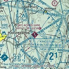
|
CAUTION: Diagram may not be current

| Airport distance calculator |
|---|
|
|
| Sunrise and sunset |
|---|
|
Times for 04-Dec-2025
| | Local
(UTC-5) | | Zulu
(UTC) |
|---|
| Morning civil twilight | | 06:35 | | 11:35 |
| Sunrise | | 07:07 | | 12:07 |
| Sunset | | 16:24 | | 21:24 |
| Evening civil twilight | | 16:55 | | 21:55 |
|
| Current date and time |
|---|
| Zulu (UTC) | 04-Dec-2025 10:35:17 |
|---|
| Local (UTC-5) | 04-Dec-2025 05:35:17 |
|---|
|
| METAR |
|---|
KPOU
8nm SW | 040953Z 23007KT 10SM CLR M01/M04 A2996 RMK AO2 SLP144 T10061044
|
KSWF
20nm SW | 040945Z 00000KT 10SM SKC M02/M05 A2995
|
|
| TAF |
|---|
KPOU
8nm SW | 040529Z 0406/0506 VRB03KT P6SM BKN120 FM041200 22005KT P6SM SCT060 BKN090 FM041600 27010G18KT P6SM BKN060 FM041900 29015G25KT P6SM SCT060 FM050100 31012G20KT P6SM SKC
|
KSWF
20nm SW | 040833Z 0409/0512 VRB02KT P6SM SCT250 FM041300 26008KT P6SM BKN080 FM041600 28015G30KT P6SM BKN060 BKN120 PROB30 0417/0419 31021G35KT 5SM -SHSN BKN030 FM042200 31014G24KT P6SM FEW035 FM050300 32009KT P6SM FEW025 FM050700 VRB03KT P6SM BKN250 AMD NOT SKED
|
|
| NOTAMs |
|---|
NOTAMs are issued by the DoD/FAA and will open in a separate window not controlled by AirNav.
|
|


