FAA INFORMATION EFFECTIVE 09 JULY 2026
Location
| FAA Identifier: | SWF |
| Lat/Long: | 41-30-14.8000N 074-06-17.4000W
41-30.246667N 074-06.290000W
41.5041111,-74.1048333
(estimated) |
| Elevation: | 490.7 ft. / 149.6 m (surveyed) |
| Variation: | 14W (1995) |
| From city: | 44 miles N of NEW YORK, NY |
| Time zone: | UTC -4 (UTC -5 during Standard Time) |
| Zip code: | 12550 |
Airport Operations
| Airport use: | Open to the public |
| Activation date: | 05/1941 |
| Control tower: | yes |
| ARTCC: | NEW YORK CENTER |
| FSS: | NEW YORK FLIGHT SERVICE STATION |
| NOTAMs facility: | SWF (NOTAM-D service available) |
| Attendance: | CONTINUOUS |
| Pattern altitude: | 1199.7 ft. MSL
TPA: 709 FT AGL HEL, 1009 FT AGL RECIPROCATING ENG, 2009 FT AGL TURBOPROP/JET. |
| Wind indicator: | lighted |
| Segmented circle: | no |
| Beacon: | white-green (lighted land airport)
Operates sunset to sunrise. |
| Landing fee: | no, LNDG FEE PER 1000 LBS. CERTIFICATED MAX TOG. |
| Fire and rescue: | ARFF index C |
| International operations: | US CUSTOMS USER FEE ARPT. |
Airport Communications
| UNICOM: | 122.95 |
| ATIS: | 124.575 |
| STEWART GROUND: | 121.9 |
| STEWART TOWER: | 121.0 254.4 |
| NEW YORK APPROACH: | 132.75 |
| NEW YORK DEPARTURE: | 132.75 |
| ANG COMD POST: | 361.4 |
| AR OPS: | 126.2 38.2FM |
| ARMY OPS: | 321.7 ;ARMY OPS 49.75 ;ARMY OPS |
| COMD POST: | 139.7 ;105AW |
| EMERG: | 121.5 243.0 |
| TRESA STAR: | 132.75 |
| WX ASOS at MGJ (7 nm W): | 119.275 (845-990-2308) |
| WX ASOS at POU (12 nm NE): | 126.75 (845-836-6748) |
Nearby radio navigation aids
| VOR radial/distance | | VOR name | | Freq | | Var |
|---|
| IGNr245/16.0 | | KINGSTON VOR/DME | | 117.60 | | 12W |
| HUOr086/22.6 | | HUGUENOT VOR/DME | | 116.10 | | 11W |
| CMKr312/27.1 | | CARMEL VOR/DME | | 116.60 | | 12W |
| PWLr247/27.7 | | PAWLING VOR/DME | | 114.30 | | 12W |
| SAXr048/32.7 | | SPARTA VORTAC | | 115.70 | | 11W |
| TEBr008/39.4 | | TETERBORO VOR/DME | | 108.40 | | 11W |
| NDB name | | Hdg/Dist | | Freq | | Var | | ID |
|---|
| STANWYCK | | 254/3.0 | | 261 | | 12W | | SKU | ... -.- ..- |
| NEELY | | 093/5.6 | | 335 | | 14W | | SW | ... .-- |
Airport Services
| Fuel available: | 100LL JET-A |
| Airframe service: | MAJOR |
| Powerplant service: | MAJOR |
| Bottled oxygen: | NONE |
| Bulk oxygen: | NONE |
Runway Information
Runway 9/27
| Dimensions: | 11817 x 150 ft. / 3602 x 46 m |
| Surface: | asphalt/grooved, in good condition |
| Weight bearing capacity: | | Single wheel: | 85.0 | | Double wheel: | 175.0 | | Double tandem: | 350.0 | | Dual double tandem: | 775.0 |
|
| Runway edge lights: | high intensity |
| RUNWAY 9 | | RUNWAY 27 |
| Latitude: | 41-30.050333N | | 41-30.442300N |
| Longitude: | 074-07.833000W | | 074-05.297642W |
| Elevation: | 490.7 ft. | | 466.6 ft. |
| Traffic pattern: | left | | left |
| Runway heading: | 092 magnetic, 078 true | | 272 magnetic, 258 true |
| Displaced threshold: | 2000 ft. | | 2000 ft. |
| Declared distances: | TORA:11817 TODA:11817 ASDA:10817 LDA:8817 | | TORA:11817 TODA:11817 ASDA:11817 LDA:9817 |
| Markings: | precision, in good condition | | precision, in good condition |
| Visual slope indicator: | 4-light PAPI on left (3.00 degrees glide path) | | 4-light PAPI on left (3.00 degrees glide path) |
| RVR equipment: | touchdown, midfield, rollout | | touchdown, midfield, rollout |
| Approach lights: | ALSF2: standard 2,400 foot high intensity approach lighting system with centerline sequenced flashers (category II or III)
ALSF-2 SFL U/S. | | |
| Runway end identifier lights: | | | yes |
| Centerline lights: | yes | | yes |
| Touchdown point: | yes, lighted | | yes, no lights |
| Instrument approach: | ILS | | ILS/DME |
| Obstructions: | 38 ft. fence, lighted, 420 ft. from runway, 550 ft. right of centerline, 5:1 slope to clear
APCH SLP 50:1 TO DTHR. | | 67 ft. tree, 1120 ft. from runway, 140 ft. right of centerline, 13:1 slope to clear
APCH SLP 46:1 TO DTHR. |
Runway 16/34
| Dimensions: | 6004 x 150 ft. / 1830 x 46 m |
| Surface: | asphalt/grooved, in good condition |
| Weight bearing capacity: | | Single wheel: | 120.0 | | Double wheel: | 190.0 | | Double tandem: | 350.0 | | Dual double tandem: | 800.0 |
|
| Runway edge lights: | high intensity |
| Runway edge markings: | MILITARY ASSAULT LANDING ZONE & BASIC MKGS WITH AIMING POINTS. |
| RUNWAY 16 | | RUNWAY 34 |
| Latitude: | 41-30.670852N | | 41-29.820092N |
| Longitude: | 074-06.083832W | | 074-05.413920W |
| Elevation: | 471.3 ft. | | 437.4 ft. |
| Traffic pattern: | left | | left |
| Runway heading: | 163 magnetic, 149 true | | 343 magnetic, 329 true |
| Declared distances: | TORA:6004 TODA:6004 ASDA:6004 LDA:6004 | | TORA:6004 TODA:6004 ASDA:6004 LDA:6004 |
| Markings: | NSTD, in good condition | | NSTD, in good condition |
| Visual slope indicator: | 4-light PAPI on left (3.00 degrees glide path)
PAPI UNUSBL BYD 5 DEGS LEFT OF CNTRLN. | | 4-light PAPI on left (3.00 degrees glide path) |
| Runway end identifier lights: | yes | | yes |
| Touchdown point: | yes, no lights | | yes, no lights |
| Obstructions: | none
+3 FT GND 140 FT FM RWY END 240 FT L. | | 17 ft. trees, 780 ft. from runway, 220 ft. right of centerline, 34:1 slope to clear |
Helipad H1
| Dimensions: | 40 x 40 ft. / 12 x 12 m |
| Surface: | asphalt, in good condition |
| Operational restrictions: | HELIPAD LCTD INTXN TWYS B & C EAST OF TWY C. |
| Latitude: | 41-30.105833N | | |
| Longitude: | 074-05.861333W | | |
| Elevation: | 453.0 ft. | | |
| Traffic pattern: | left | | left |
| Markings: | basic, in good condition | | |
Airport Ownership and Management from official FAA records
| Ownership: | Publicly-owned |
| Owner: | PORT AUTHORITY OF NY & NJ
1180 FIRST ST
NEW WINDSOR, NY 12553
Phone 845-838-8200
LEASEE PANYNJ; . PROPERTY OWNED BY NYSDOT 1220 WASHINGTON AVE. ALBANY, NY 12226. TELEPHONE 518-457-2822. |
| Manager: | OMAR ASTACIO
1180 FIRST ST
NEW WINDSOR, NY 12553
Phone 845-838-8200 |
Additional Remarks
| A39-09/27 | PCR VALUE: 733/F/B/X/T |
| A39-16/34 | PCR VALUE: 733/F/B/X/T |
| - | AVOID ORANGE COUNTY ARPT LCTD 7 NM WNW DURG VFR APCHS. |
| - | NOISE ABATEMENT PROCEDURES IN EFFECT CTC AMGR 845-838-8200. |
| - | RGT TFC ON RWYS 16 & 27 MAY BE USED FOR NOISE ABATEMENT. |
| - | USER FEE CHARGED TO ALL INTL FLIGHTS. |
| - | COMPASS CALIBRATION PAD LCTD ON THE TWY G RUNUP APRON. |
| - | TWYS B & H RESTRICTED TO ACFT WITH WINGSPAN GTR THAN 118 FT. |
| - | TWY C RSTRD TO ACFT WITH WINGSPAN GTR THAN 125 FT BTN TRML BLDG & BLDG 118. |
| - | ACFT WITH WINGSPAN 172 FT OR MORE RQR VEHICLE ESCORT FOR ALL TWY C OPNS S OF TRML APN. CTC ARPT OPNS 845-838-8237. |
| - | MILITARY: ARMY OPS 1300-2100Z++ WEEKDAYS EXC HOL, O845-567-1209, OT CTC FBO. 24 HR PPR ONLY FOR PARKING ARMY RAMP. NO SVC AVAIL THROUGH ARMY RAMP, CTC FBO. 48 HR PPR ALL OPERATIONS ON WEST POINT MILITARY RESERVATION, CTC 2ND AVN DET OPSO, O845-567-1209, C845-372-3349. |
| - | MILITARY: ALL MIL ACFT OPR, BASH PHASE II PERIOD (1 APR-30 MAY & 1 AUG-30 NOV) BIRD WATCH COND SEVERE (TKOF AND LDGS PROH UNLESS GREATER EMERG AND/OR IMMED OPERATIONAL NECESSITY EXISTS. LCL AND TACTICAL TRNG PROH) MODERATE (MULTIPLE APCHS PROH A DEPARTURE AND FULL STOP ALLOWED IF RTE AVOIDS BIRDS ACT.) |
| - | MILITARY: AFLD MGR DOES NOT ISSUE OR STORE COMSEC FOR TRAN CREWS. TMPRY STOR OF CLASSIFIED MATERIALS UP TO SECRET AT COMD POST. |
| - | TWY C BTN TWY B & TWY F NOT VISIBLE FM TWR. |
| - | TWY L CLSD EXC 20 MIN PPR. TWY L APRON FOLLOW ME VEHICLE REQUIRED. CTC ARPT OPNS 845-838-8237. |
| - | BIRDS & DEER ON & INVOF ARPT. |
| - | FUEL: A++ AVBL. |
| - | MILITARY: ADVSY FOR TRAN AIRCREW - NSTD WHITE VEH PARKING BOXES AND C-17 WING-TIP GUIDE LINES PAINTED ON ANG RAMP. |
| - | MILITARY: COMD POST OPR 1000-0400++, DSN 636-2286. |
| - | ALL SFCS. WORK IN PROGRESS GRASS CUTTING CONDUCTED APR-OCT. |
| - | TXL C NOT VSB TO TWR FOR ACFT PUSHBACK FM PAX TRML; CTC GND FREQ FOR PUSHBACK ONTO TXL C. |
| - | NO JET TRNG 2300 TO 0700 DLY. |
| - | HUDSON VALLEY RGNL LCTD 3.3 NM SW IGN VORTAC; DO NOT MISTAKE FOR STEWART INTL. |
| - | EXTSV GLDR ACT 8 MI E OF HUO VORTAC IN A 5-MI RADIUS. |
Instrument Procedures
NOTE: All procedures below are presented as PDF files. If you need a reader for these files, you should download the free Adobe Reader.NOT FOR NAVIGATION. Please procure official charts for flight.
FAA instrument procedures published for use from 09 July 2026 at 0901Z to 06 August 2026 at 0900Z.
STARs - Standard Terminal Arrivals |
|---|
| TRESA TWO (RNAV) **NEW** | |
download (126KB) |
IAPs - Instrument Approach Procedures |
|---|
| ILS OR LOC RWY 09 | |
download (239KB) |
| ILS OR LOC RWY 27 | |
download (220KB) |
| ILS RWY 09 (SA CAT I) | |
download (231KB) |
| ILS RWY 09 (CAT II - III) | |
download (243KB) |
| RNAV (GPS) RWY 09 | |
download (215KB) |
| RNAV (GPS) RWY 16 | |
download (222KB) |
| RNAV (GPS) RWY 27 | |
download (209KB) |
| RNAV (GPS) RWY 34 | |
download (204KB) |
| NOTE: Special Alternate Minimums apply | |
download (145KB) |
Departure Procedures |
|---|
| STEWART NINE | |
2 pages:
[1] [2] (334KB) |
| NOTE: Special Take-Off Minimums/Departure Procedures apply | |
download (378KB) |
Other nearby airports with instrument procedures:
KMGJ - Orange County Airport (7 nm W)
KPOU - Hudson Valley Regional Airport (12 nm NE)
06N - Randall Airport (14 nm W)
N82 - Wurtsboro/Sullivan County Airport (17 nm W)
N89 - Joseph Y Resnick Airport (18 nm NW)
|
|

Road maps at:
MapQuest
Bing
Google
| Aerial photo |
|---|
WARNING: Photo may not be current or correct
 Photo by Cathy Vajtay
Photo taken 26-Nov-2011
looking south.
Photo by Cathy Vajtay
Photo taken 26-Nov-2011
looking south.
Do you have a better or more recent aerial photo of New York Stewart International Airport that you would like to share? If so, please send us your photo.
|
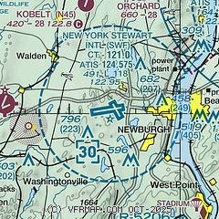
| Sectional chart |
|---|
|
CAUTION: Diagram may not be current
 Download PDF
of official airport diagram from the FAA
| Airport distance calculator |
|---|
|
|
| Sunrise and sunset |
|---|
|
Times for 19-Jul-2026
| | Local
(UTC-4) | | Zulu
(UTC) |
|---|
| Morning civil twilight | | 05:07 | | 09:07 |
| Sunrise | | 05:40 | | 09:40 |
| Sunset | | 20:25 | | 00:25 |
| Evening civil twilight | | 20:58 | | 00:58 |
|
| Current date and time |
|---|
| Zulu (UTC) | 19-Jul-2026 23:05:05 |
|---|
| Local (UTC-4) | 19-Jul-2026 19:05:05 |
|---|
|
| METAR |
|---|
| KSWF | 192245Z 32010KT 10SM SKC 25/10 A2985
|
KMGJ
7nm W | SuperAWOS
192254Z AUTO 34007KT 10SM CLR 24/09 A2987 RMK AO2 SLP112 T02390089 $
|
KPOU
13nm NE | 192253Z 33007KT 10SM CLR 25/09 A2984 RMK AO2 SLP101 T02500089
|
|
| TAF |
|---|
| KSWF | 191943Z 1920/2024 31012G20KT P6SM SCT250 FM192200 32008KT P6SM FEW250 FM200100 33005KT P6SM SKC FM200700 VRB03KT P6SM SKC FM201900 24006KT P6SM FEW250 AMD NOT SKED
|
KPOU
13nm NE | 191720Z 1918/2018 32009G12KT P6SM FEW040 FM192300 32007KT P6SM SKC FM200200 00000KT P6SM SKC
|
|
| NOTAMs |
|---|
NOTAMs are issued by the DoD/FAA and will open in a separate window not controlled by AirNav.
|
|


