FAA INFORMATION EFFECTIVE 14 MAY 2026
Location
| FAA Identifier: | 4S9 |
| Lat/Long: | 45-12-59.6000N 122-35-24.7000W
45-12.993333N 122-35.411667W
45.2165556,-122.5901944
(estimated) |
| Elevation: | 259.9 ft. / 79.2 m (surveyed) |
| Variation: | 19E (1985) |
| From city: | 20 miles S of PORTLAND-MULINO, OR |
| Time zone: | UTC -7 (UTC -8 during Standard Time) |
| Zip code: | 97013 |
Airport Operations
| Airport use: | Open to the public |
| Activation date: | 06/1948 |
| Control tower: | no |
| ARTCC: | SEATTLE CENTER |
| FSS: | MC MINNVILLE FLIGHT SERVICE STATION |
| NOTAMs facility: | MMV (NOTAM-D service available) |
| Attendance: | UNATNDD |
| Wind indicator: | lighted |
| Segmented circle: | yes |
| Lights: | ACTIVATE MIRL RY 14/32, TWY LGTS, & WINDCONE - CTAF. PAPI RYS 14 & 32 OPR 24 HRS. |
| Beacon: | white-green (lighted land airport)
Operates sunset to sunrise. |
Airport Communications
| CTAF/UNICOM: | 123.05 |
| CLEARANCE DELIVERY: | 119.95 |
| WX ASOS at UAO (8 nm W): | 118.525 (503-678-3011) |
Nearby radio navigation aids
| VOR radial/distance | | VOR name | | Freq | | Var |
|---|
| UBGr096/18.3 | | NEWBERG VOR/DME | | 117.40 | | 21E |
| BTGr159/31.9 | | BATTLE GROUND VORTAC | | 116.60 | | 21E |
| NDB name | | Hdg/Dist | | Freq | | Var | | ID |
|---|
| BANKS | | 126/31.4 | | 356 | | 16E | | PND | .--. -. -.. |
Airport Services
| Fuel available: | 100LL |
| Parking: | tiedowns |
| Airframe service: | MAJOR |
| Powerplant service: | MAJOR |
| Bottled oxygen: | NONE |
| Bulk oxygen: | NONE |
Runway Information
Runway 14/32
| Dimensions: | 3425 x 100 ft. / 1044 x 30 m |
| Surface: | asphalt, in good condition |
| Runway edge lights: | medium intensity |
| RUNWAY 14 | | RUNWAY 32 |
| Latitude: | 45-13.257097N | | 45-12.729090N |
| Longitude: | 122-35.551785W | | 122-35.272630W |
| Elevation: | 247.8 ft. | | 259.9 ft. |
| Traffic pattern: | right | | left |
| Runway heading: | 140 magnetic, 159 true | | 321 magnetic, 340 true |
| Markings: | basic, in good condition | | basic, in good condition |
| Visual slope indicator: | 2-light PAPI on left (3.00 degrees glide path) | | 2-light PAPI on left (3.00 degrees glide path)
PAPI OTS INDEF. |
| Touchdown point: | yes, no lights | | yes, no lights |
| Obstructions: | 77 ft. tree, 1002 ft. from runway, 194 ft. right of centerline, 10:1 slope to clear | | 212 ft. trees, 3059 ft. from runway, 138 ft. right of centerline, 13:1 slope to clear |
Airport Ownership and Management from official FAA records
| Ownership: | Publicly-owned |
| Owner: | OREGON DEPARTMENT OF AVIATION
3040 25TH STREET SE
SALEM, OR 97302
Phone 503-378-4880 |
| Manager: | OREGON DEPARTMENT OF AVIATION
3040 25TH STREET SE
SALEM, OR 97302
Phone 503-378-4880 |
Additional Remarks
| - | RY 32 DESIGNATED CALM WIND RY. |
| - | WILDLIFE ON & INVOF OF ARPT. |
| - | BE ALERT FOR WEEKEND GLIDER ACTIVITY. |
| - | SKYDIVING ACTIVITY ON AND IN VICINITY OF AIRPORT. LANDING ZONE 1400' EAST OF RUNWAY. |
| - | FOR CD CTC PORTLAND APCH AT 503-493-7545. |
Instrument Procedures
There are no published instrument procedures at 4S9.
Some nearby airports with instrument procedures:
KUAO - Aurora State Airport (8 nm W)
KTTD - Portland-Troutdale Airport (21 nm N)
KPDX - Portland International Airport (22 nm N)
KMMV - Mc Minnville Municipal Airport (23 nm W)
KVUO - Pearson Field Airport (24 nm N)
|
|

Road maps at:
MapQuest
Bing
Google
| Aerial photo |
|---|
WARNING: Photo may not be current or correct
 Photo taken 20-Apr-2007
Do you have a better or more recent aerial photo of Mulino State Airport that you would like to share? If so, please send us your photo.
|
| Sectional chart |
|---|
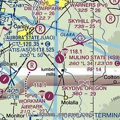
|
| Airport distance calculator |
|---|
|
|
| Sunrise and sunset |
|---|
|
Times for 18-May-2026
| | Local
(UTC-7) | | Zulu
(UTC) |
|---|
| Morning civil twilight | | 05:03 | | 12:03 |
| Sunrise | | 05:38 | | 12:38 |
| Sunset | | 20:35 | | 03:35 |
| Evening civil twilight | | 21:10 | | 04:10 |
|
| Current date and time |
|---|
| Zulu (UTC) | 18-May-2026 13:09:54 |
|---|
| Local (UTC-7) | 18-May-2026 06:09:54 |
|---|
|
| METAR |
|---|
KUAO
8nm W | 181253Z AUTO 00000KT 10SM CLR 07/06 A3027 RMK AO2 SLP249 T00720061 $
|
|
| TAF |
|---|
KUAO
8nm W | 181124Z 1812/1912 02003KT P6SM BKN200 FM182200 35007KT P6SM SCT250 FM190900 01003KT P6SM SCT050
|
|
| NOTAMs |
|---|
NOTAMs are issued by the DoD/FAA and will open in a separate window not controlled by AirNav.
|
|

