FAA INFORMATION EFFECTIVE 14 MAY 2026
Location
| FAA Identifier: | PDX |
| Lat/Long: | 45-35-19.3519N 122-35-48.7299W
45-35.322532N 122-35.812165W
45.5887089,-122.5968694
(estimated) |
| Elevation: | 30.8 ft. / 9.4 m (surveyed) |
| Variation: | 16E (2010) |
| From city: | 4 miles NE of PORTLAND, OR |
| Time zone: | UTC -7 (UTC -8 during Standard Time) |
| Zip code: | 97218 |
Airport Operations
| Airport use: | Open to the public |
| Activation date: | 03/1940 |
| Control tower: | yes |
| ARTCC: | SEATTLE CENTER |
| FSS: | MC MINNVILLE FLIGHT SERVICE STATION |
| NOTAMs facility: | PDX (NOTAM-D service available) |
| Attendance: | CONTINUOUS |
| Wind indicator: | lighted |
| Segmented circle: | no |
| Lights: | SS-SR |
| Beacon: | white-green (lighted land airport)
Operates sunset to sunrise. |
| Landing fee: | yes, COMMERCIAL ACFT & OPERATORS OF ACFT WITH AN FAA CERTIFIED MAX GROSS LANDING WEIGHT THAT EXCEEDS 10000 LBS ARE REQUIRED TO PAY A LANDING FEE. |
| Fire and rescue: | ARFF index E |
| International operations: | customs landing rights airport |
Airport Communications
| UNICOM: | 122.95 |
| WX ASOS: | PHONE 458-212-2405 |
| PORTLAND GROUND: | 121.9 348.6 132.275 |
| PORTLAND TOWER: | 118.7 ;RWY 10L/28R 123.775 ;RWY 03/21, 10R/28L 251.125 ;RWY 03/21, 10R/28L 257.8 ;RWY 10L/28R |
| PORTLAND APPROACH: | 118.1 ;100-279, HIGH 124.35 ;280-099 126.9 ;FINAL |
| PORTLAND DEPARTURE: | 118.1 ;100-279, HIGH 124.35 ;280-099 127.85 |
| CLEARANCE DELIVERY: | 120.125 318.1 |
| AFRC OPS: | 138.45 252.8 |
| ANG COMD POST: | 288.9 ;CALL STUMP TOWN |
| ANG OPS: | 280.5 281.2 |
| CASCADE DP: | 118.1 |
| CLASS C: | 118.1 ;100-279, HIGH 124.35 ;280-099 |
| D-ATIS: | 128.35 269.9 |
| EMERG: | 121.5 243.0 |
| HELNS STAR: | 124.35 |
| HHOOD STAR: | 124.35 |
| HRMNS DP: | 118.1 |
| IC: | 124.35 ;280-099 |
| LAVAA DP: | 124.35 |
| MINNE DP: | 118.1 |
| OCITY STAR: | 124.35 |
| TMBRS STAR: | 124.35 |
| WHAMY DP: | 118.1 |
| WX ASOS at VUO (3 nm NW): | 135.125 (360-696-1280) |
| WX ASOS at TTD (9 nm E): | 135.625 (503-492-2887) |
| WX ASOS at HIO (15 nm W): | PHONE 503-615-4314 |
| WX ASOS at SPB (16 nm NW): | 135.875 (503-543-6401) |
- OPERATIONS CALL- SAVE -OPERATED BY AFR, 24 HRS
- ASSC IN USE. OPERATE TRANSPONDERS WITH ALTITUDE REPORTING MODE AND ADS-B (IF EQUIPPED) ENABLED ON ALL AIRPORT SURFACES.
- PDX MONITORS 121.5 FOR MCMINNVILLE (MMV).
Nearby radio navigation aids
| VOR radial/distance | | VOR name | | Freq | | Var |
|---|
| BTGr160/9.5 | | BATTLE GROUND VORTAC | | 116.60 | | 21E |
| UBGr028/21.4 | | NEWBERG VOR/DME | | 117.40 | | 21E |
| NDB name | | Hdg/Dist | | Freq | | Var | | ID |
|---|
| BANKS | | 082/19.0 | | 356 | | 16E | | PND | .--. -. -.. |
Airport Services
| Fuel available: | 100LL JET-A |
| Parking: | hangars and tiedowns |
| Airframe service: | MAJOR |
| Powerplant service: | MAJOR |
| Bottled oxygen: | HIGH/LOW |
| Bulk oxygen: | HIGH/LOW |
Runway Information
Runway 10R/28L
| Dimensions: | 11000 x 150 ft. / 3353 x 46 m |
| Surface: | concrete/grooved, in good condition |
| Weight bearing capacity: | | Single wheel: | 200.0 | | Double wheel: | 200.0 | | Double tandem: | 360.0 |
|
| Runway edge lights: | high intensity |
| RUNWAY 10R | | RUNWAY 28L |
| Latitude: | 45-35.708912N | | 45-34.830885N |
| Longitude: | 122-37.288370W | | 122-35.034105W |
| Elevation: | 22.7 ft. | | 22.7 ft. |
| Traffic pattern: | right | | left |
| Runway heading: | 103 magnetic, 119 true | | 283 magnetic, 299 true |
| Declared distances: | TORA:11000 TODA:11000 ASDA:11000 LDA:11000 | | TORA:11000 TODA:11000 ASDA:11000 LDA:11000 |
| Markings: | precision, in good condition | | precision, in good condition |
| Visual slope indicator: | 4-light PAPI on right (3.00 degrees glide path) | | 4-light PAPI on left (3.00 degrees glide path)
POSSIBLE RWY 28L GLIDESLOPE FLUCTUATION PRIOR TO ADDUM WHEN WEATHER IS GREATER THAN 800/2. |
| RVR equipment: | touchdown, midfield, rollout | | touchdown, midfield, rollout |
| Approach lights: | ALSF2: standard 2,400 foot high intensity approach lighting system with centerline sequenced flashers (category II or III) | | MALSR: 1,400 foot medium intensity approach lighting system with runway alignment indicator lights |
| Centerline lights: | yes | | yes |
| Touchdown point: | yes, lighted | | yes, no lights |
| Instrument approach: | ILS/DME | | ILS/DME |
Runway 10L/28R
| Dimensions: | 9825 x 150 ft. / 2995 x 46 m |
| Surface: | asphalt/grooved, in excellent condition |
| Weight bearing capacity: | | Single wheel: | 200.0 | | Double wheel: | 200.0 | | Double tandem: | 400.0 |
|
| Runway edge lights: | high intensity |
| RUNWAY 10L | | RUNWAY 28R |
| Latitude: | 45-35.790900N | | 45-35.006308N |
| Longitude: | 122-36.000968W | | 122-33.987727W |
| Elevation: | 29.5 ft. | | 30.8 ft. |
| Traffic pattern: | left | | right |
| Runway heading: | 103 magnetic, 119 true | | 283 magnetic, 299 true |
| Displaced threshold: | 1290 ft. | | 535 ft. |
| Declared distances: | TORA:9825 TODA:9825 ASDA:9825 LDA:8535 | | TORA:9825 TODA:9825 ASDA:9825 LDA:9290 |
| Markings: | precision, in good condition | | precision, in good condition |
| Visual slope indicator: | 4-light PAPI on left (3.00 degrees glide path) | | 4-light PAPI on right (3.00 degrees glide path) |
| RVR equipment: | touchdown, midfield, rollout | | touchdown, midfield, rollout |
| Approach lights: | MALSR: 1,400 foot medium intensity approach lighting system with runway alignment indicator lights | | MALSR: 1,400 foot medium intensity approach lighting system with runway alignment indicator lights |
| Centerline lights: | yes | | yes |
| Touchdown point: | yes, no lights | | yes, no lights |
| Instrument approach: | ILS/DME | | ILS/DME |
| Obstructions: | none | | 32 ft. road, 200 ft. from runway, 408 ft. right of centerline
RWY 28R 60' LEVEE ROAD LCTD APRXLY PARALLEL TO RWY AT 200' FM THR AND 507' RT FM RWY EXTNDD CNTRLN. |
Runway 3/21
| Dimensions: | 6000 x 150 ft. / 1829 x 46 m |
| Surface: | asphalt/grooved, in excellent condition |
| Weight bearing capacity: | | Single wheel: | 120.0 | | Double wheel: | 250.0 | | Double tandem: | 380.0 |
|
| Runway edge lights: | medium intensity |
| Operational restrictions: | RY 21 CLSD TO HEIGHT GROUP IV ACFT WITH COCKPIT TO WHEEL HEIGHT GREATER THAN 22 FT. |
| RUNWAY 3 | | RUNWAY 21 |
| Latitude: | 45-34.945500N | | 45-35.643417N |
| Longitude: | 122-37.008647W | | 122-36.014105W |
| Elevation: | 22.2 ft. | | 26.4 ft. |
| Traffic pattern: | left | | left |
| Runway heading: | 029 magnetic, 045 true | | 209 magnetic, 225 true |
| Declared distances: | TORA:6000 TODA:6000 ASDA:6000 LDA:6000 | | TORA:6000 TODA:6000 ASDA:6000 LDA:6000 |
| Markings: | nonprecision, in good condition | | nonprecision, in good condition |
| Visual slope indicator: | 4-light PAPI on left (3.30 degrees glide path)
PDX RWY 03 PAPI UNUSABLE BYND 4 DEG LEFT AND RIGHT OF RCL AND BEYOND 5 NM UNUSABLE | | 4-light PAPI on right (3.60 degrees glide path) |
| Runway end identifier lights: | yes | | yes |
| Touchdown point: | yes, no lights | | yes, no lights |
| Instrument approach: | | | LOC/DME |
| Obstructions: | none | | 19 ft. road, 475 ft. from runway, 14:1 slope to clear |
Airport Ownership and Management from official FAA records
| Ownership: | Publicly-owned |
| Owner: | THE PORT OF PORTLAND
BOX 3529
PORTLAND, OR 97208
Phone 503-415-6000 |
| Manager: | STEPHEN NAGY
7200 NE AIRPORT WAY
PORTLAND, OR 97218
Phone 503-415-6195
ARPT OPS GENERAL MGR |
Additional Remarks
| A39-10L/28R | PCR VALUE: 2270/F/D/X/T |
| A39-03/21 | PCR VALUE: 400/F/D/X/T |
| A39-10R/28L | PCR VALUE: 1200/R/D/W/T |
| E60-28L | TYPE-H BAK-12B(B) (2000'). |
| E60-10R | TYPE-H BAK-12B(B) (1625'). |
| E94 | WSFO/WSO/FW/RFC. |
| - | UNCONTROLLED TFC AT PEARSON FIELD VANCOUVER WA 3 NM W OF RY 10L THLD ON EXTDD CNTRLN. |
| - | AREA OF TWY T BTN M & E3 NOT VSB FM TWR. |
| - | ACFT AUTHORIZED TO UTILIZE THE NORTHWEST RAMP WILL BE TOWED TO/FROM THIS RAMP. |
| - | AT THE WEST END ARM/DEARM AREA ON TWY C NO ACFT OF ANY TYPE MAY TAXI PAST THE ARM/DEARM AREA WHILE IT IS BEING USED. |
| - | ARPT CLSD TO NON-POWERED ACFT EXCP IN EMERG. |
| - | BEARING STRENGTH: RWY 03-21 ST 175, RY 10L-28R ST175, RY 10R-28L ST175. |
| - | JASU - 4(A/M32A-86) (MC-11) 1(MA-1A). |
| - | FUEL - A (AIR BP - ATLANTIC AVIATION SVCS. C503-331-4220) J8(MIL) (NC-100LL, A) |
| - | FLUID - LHOXRB. |
| - | OIL - O-128-133-148(MIL). |
| - | MISC: FLT NOTIFICATION SVC, ADCUS, AVBL. |
| - | ANG : PPR/OFFL BUS ONLY. BASE OPS OPR 1500-2300Z++ MON-FRI EXC HOL.; DSN 638-4390, C503-335-4390. CTC BASE OPS 15 MIN PRIOR TO LDG AND AFTER DEP ON 281.2. TRAN QUARTERS NOT AVBL. CAUTION: OBST LIGHTING IS NOT NVD COMPATIBLE. NVD NOT AUTHORIZED WHILE AIRBORNE IN VCNTY OF AFLD. |
| - | TWY V CLSD TO ACFT WITH WINGSPAN GREATER THAN 168 FT. ACFT WITH WINGSPAN GREATER THAN 118 FT PROHIBITED FM TURNING WB ONTO TWY A FM TWY V UNLESS UNDER TOW. |
| - | ANG: SEE FLIP AP/1 FOR SUPPLEMENTARY ARPT INFO. HAZARDOUS BIRD COND EXIST. PHASE 1 MAY-OCT, PHASE II NOV-APR. CURRENT BIRD WATCH CONDITIONS ARE NOT REPORTED ON ATIS. |
| - | TWY W CLSD TO ACFT WITH WINGSPAN GTR THAN 118 FT UNLESS UNDER TOW. |
| - | TWY T BTN EXITS B5 & B6 CLSD TO ACFT WITH WINGSPAN GTR THAN 118 FT. |
| - | NSTD YELLOW PRK SPOT DESIGNATORS AND EQPT TOOL BOX LCTN PAINTED ON RAMP, WHITE RWR BOXES BOXES AND WHITE WINGTIP LINES ON MILTWY. PLEASE CTC BASE OPS OR REQ FOLLOW ME IF NOT FAMILIAR WITH PANGB PRK PROCEDURES. |
| - | TWY C3 CLSD TO ACFT WITH WINGSPAN EQUAL TO OR GTR THAN 79 FT. |
| - | PDX HAS FAC CONSTRAINTS THAT LMT ITS ABILITY TO ACCOMMODATE DIVD FLTS & MNTN THE ARPT SAFE OPN DUR IREG OPS. ACFT OPRS SHUD CTC THE ARPT DUTY MGR AT (503) 460-4236 TO COORD DIVD FLTS EXC IN THE CASE OF A DECLARED IN-FLT EMERG. |
| - | ACFT WITH WINGSPAN GREATER THAN 118 FEET ARE PROHIBITED FROM TURNING EASTBOUND ON TWY C FROM SOUTHWESTBOUND ON TWY F UNLESS UNDER TOW. |
| - | TWY A3 BTN TWY A & THE GA RAMP CLSD TO ACFT WITH WINGSPAN GTR THAN 135 FEET UNLESS UNDER TOW. |
| - | TWY C BTN TWY C6 AND TWY C8 CLSD TO ACFT WITH WINGSPAN GTR THAN 200 FT. |
| - | TWY K BTN TWY A5 & TWY V CLSD TO ACFT WINGSPAN MORE THAN 168 FT. |
| - | MIGRATORY & WINTERING FLOCKS OF LRG WATERFOWL ON & INVOF APRT. HEAVY SEAGULL ACTIVITY SEP THRU APR; EXPECT HIGH NMBR OF BIRDS YEAR AROUND; CK LCL ADVISORIES. |
| - | TWY K BTN TWY V & TWY A4 CLSD TO ACFT WINGSPAN MORE THAN 118 FT. |
| - | MILITARY: ANG: OREGON ANG E RAMP SUN SHADE OBST LGTS O/S. |
| - | ANG - EAST END ARM/DEARM AREA ON MIL TWY LACKS ADEQUATE WINGTIP CLNC. MULTIPLE FIRE HYDRANTS DO NOT MEET CLNC REQUIREMENTS. NO TACAN DESIGNATION SIGN. |
| - | NOISE ABATEMENT PROCEDURES IN EFFECT; CALL NOISE OFFICE AT 503-460-4100. RY 28L ARRIVALS ARE NOISE SENSITIVE, EXPECT APCH TO 28R WITH TRANSITION TO 28L. |
| - | 180 DEGREE TURNS BY ACFT WEIGHING IN EXCESS OF 12500 LBS PROHIBITED ON RY 10L/28R, RY 03/21 AND ALL TWYS. |
Instrument Procedures
NOTE: All procedures below are presented as PDF files. If you need a reader for these files, you should download the free Adobe Reader.NOT FOR NAVIGATION. Please procure official charts for flight.
FAA instrument procedures published for use from 14 May 2026 at 0901Z to 11 June 2026 at 0900Z.
STARs - Standard Terminal Arrivals |
|---|
| HELNS SIX | |
download (192KB) |
| HHOOD SIX (RNAV) | |
2 pages:
[1] [2] (511KB) |
| KRATR THREE (RNAV) | |
2 pages:
[1] [2] (352KB) |
| OCITY THREE | |
download (255KB) |
| TMBRS FOUR (RNAV) | |
2 pages:
[1] [2] (437KB) |
| TMBRS FOUR (RNAV), CONT.2 | |
download (230KB) |
IAPs - Instrument Approach Procedures |
|---|
| HI-ILS OR LOC RWY 10R | |
download (483KB) |
| HI-ILS OR LOC RWY 28R | |
download (477KB) |
| ILS OR LOC RWY 10L | |
download (322KB) |
| ILS OR LOC RWY 10R | |
download (437KB) |
| ILS OR LOC RWY 28L | |
download (431KB) |
| ILS OR LOC RWY 28R | |
download (432KB) |
| ILS RWY 10R (SA CAT I) | |
download (313KB) |
| ILS RWY 10R (CAT II - III) | |
download (321KB) |
| RNAV (RNP) Y RWY 28L | |
download (283KB) |
| RNAV (RNP) Y RWY 28R | |
download (283KB) |
| RNAV (RNP) Z RWY 10L | |
download (258KB) |
| RNAV (RNP) Z RWY 10R | |
download (294KB) |
| RNAV (RNP) Z RWY 28L | |
download (222KB) |
| RNAV (RNP) Z RWY 28R | |
download (312KB) |
| RNAV (GPS) X RWY 28L | |
download (369KB) |
| RNAV (GPS) X RWY 28R | |
download (357KB) |
| RNAV (GPS) Y RWY 10L | |
download (325KB) |
| RNAV (GPS) Y RWY 10R | |
download (299KB) |
| LOC/DME RWY 21 | |
download (427KB) |
| VOR-A | |
download (298KB) |
| HI-TACAN RWY 10R | |
download (556KB) |
| TACAN RWY 28L | |
download (301KB) |
| COLUMBIA VISUAL RWY 10L/R | |
download (152KB) |
| MILL VISUAL RWY 28L/R | |
download (170KB) |
| NOTE: Special Alternate Minimums apply | |
download (211KB) |
Departure Procedures |
|---|
| CASCADE FOUR (RNAV) | |
download (280KB) |
| HRMNS SIX (RNAV) | |
download (232KB) |
| LAVAA SEVEN (RNAV) | |
download (251KB) |
| MINNE FIVE (RNAV) | |
download (232KB) |
| PORTLAND TWO | |
2 pages:
[1] [2] (373KB) |
| WHAMY FIVE (RNAV) | |
download (259KB) |
| NOTE: Special Take-Off Minimums/Departure Procedures apply | |
download (223KB) |
Other nearby airports with instrument procedures:
KVUO - Pearson Field Airport (3 nm NW)
KTTD - Portland-Troutdale Airport (9 nm E)
KHIO - Portland-Hillsboro Airport (15 nm W)
KSPB - Scappoose Airport (16 nm NW)
KUAO - Aurora State Airport (22 nm S)
|
|

Road maps at:
MapQuest
Bing
Google
| Aerial photo |
|---|
WARNING: Photo may not be current or correct
 Photo taken 09-Jul-2009
Do you have a better or more recent aerial photo of Portland International Airport that you would like to share? If so, please send us your photo.
|
| Sectional chart |
|---|
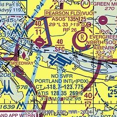
|
 Download PDF
of official airport diagram from the FAA
| Airport distance calculator |
|---|
|
|
| Sunrise and sunset |
|---|
|
Times for 01-Jun-2026
| | Local
(UTC-7) | | Zulu
(UTC) |
|---|
| Morning civil twilight | | 04:49 | | 11:49 |
| Sunrise | | 05:26 | | 12:26 |
| Sunset | | 20:51 | | 03:51 |
| Evening civil twilight | | 21:28 | | 04:28 |
|
| Current date and time |
|---|
| Zulu (UTC) | 01-Jun-2026 09:05:04 |
|---|
| Local (UTC-7) | 01-Jun-2026 02:05:04 |
|---|
|
| METAR |
|---|
| KPDX | 010853Z 32003KT 10SM CLR 13/06 A3019 RMK AO2 SLP221 T01280056 58000 $
|
KVUO
3nm NW | 010853Z AUTO 00000KT 10SM CLR 12/06 A3020 RMK AO2 SLP227 T01220056 50000
|
KTTD
8nm E | 010853Z 00000KT 10SM CLR 11/07 A3018 RMK AO2 SLP221 T01110067 50000
|
KHIO
15nm W | 010253Z 30011KT 10SM CLR 18/06 A3019
|
KSPB
16nm NW | 010853Z AUTO 35005KT 10SM CLR 13/04 A3018 RMK AO2 SLP219 T01280039 58003 $
|
|
| TAF |
|---|
| KPDX | 010520Z 0106/0206 32010G20KT P6SM SKC FM010700 31007KT P6SM SKC FM011800 34010KT P6SM SKC
|
KTTD
8nm E | 010520Z 0106/0206 VRB05KT P6SM SKC FM011900 08008KT P6SM SKC
|
KHIO
15nm W | 010520Z 0106/0206 31011KT P6SM SKC FM010800 VRB04KT P6SM SKC FM011800 02007KT P6SM SKC
|
|
| NOTAMs |
|---|
NOTAMs are issued by the DoD/FAA and will open in a separate window not controlled by AirNav.
|
|


