FAA INFORMATION EFFECTIVE 14 MAY 2026
Location
| FAA Identifier: | 50D |
| Lat/Long: | 46-00-32.6868N 088-16-26.4923W
46-00.544780N 088-16.441538W
46.0090797,-88.2740256
(estimated) |
| Elevation: | 1340 ft. / 408.4 m (surveyed) |
| Variation: | 02W (1985) |
| From city: | 6 miles SE of CRYSTAL FALLS, MI |
| Time zone: | UTC -5 (UTC -6 during Standard Time) |
| Zip code: | 54121 |
Airport Operations
| Airport use: | Open to the public |
| Activation date: | 05/1959 |
| Control tower: | no |
| ARTCC: | MINNEAPOLIS CENTER |
| FSS: | GREEN BAY FLIGHT SERVICE STATION |
| NOTAMs facility: | GRB (NOTAM-D service available) |
| Attendance: | UNATNDD |
| Wind indicator: | lighted |
| Segmented circle: | yes |
| Lights: | ACTVT NSTD LIRL RWY 12/30 - 121.7 |
Airport Communications
| CTAF: | 122.9 |
| WX ASOS at IMT (13 nm SE): | 119.025 (906-774-1999) |
Airport Services
| Parking: | tiedowns |
| Powerplant service: | NONE |
| Bottled oxygen: | NONE |
| Bulk oxygen: | NONE |
Runway Information
Runway 12/30
| Dimensions: | 3690 x 50 ft. / 1125 x 15 m |
| Surface: | asphalt, in fair condition
NMRS CRACKS & VEGETATION IN PAVEMENT. |
| Runway edge lights: | non-standard
NSTD LIRL DUE TO 36 FT FM RWY EDGE. |
| RUNWAY 12 | | RUNWAY 30 |
| Latitude: | 46-00.657143N | | 46-00.391000N |
| Longitude: | 088-16.850000W | | 088-16.066833W |
| Elevation: | 1336.0 ft. | | 1334.0 ft. |
| Traffic pattern: | left | | left |
| Runway heading: | 118 magnetic, 116 true | | 298 magnetic, 296 true |
| Markings: | numbers only, in good condition | | numbers only, in good condition |
| Obstructions: | 33 ft. trees, 468 ft. from runway, 60 ft. right of centerline, 8:1 slope to clear | | 22 ft. trees, 350 ft. from runway, 130 ft. left of centerline, 6:1 slope to clear |
Runway 2/20
| Dimensions: | 2700 x 145 ft. / 823 x 44 m |
| Surface: | turf, in fair condition
ROUGH IN AREAS; NMRS CRACKS IN PAVEMENT. |
| Runway edge markings: | 3 FT YELLOW CONES. |
| RUNWAY 2 | | RUNWAY 20 |
| Latitude: | 46-00.365040N | | 46-00.780833N |
| Longitude: | 088-16.530540W | | 088-16.306400W |
| Elevation: | 1330.0 ft. | | 1340.0 ft. |
| Traffic pattern: | left | | left |
| Runway heading: | 022 magnetic, 020 true | | 202 magnetic, 200 true |
| Obstructions: | 30 ft. trees, 40 ft. from runway, 129 ft. left of centerline, 1:1 slope to clear | | 45 ft. tree, 235 ft. from runway, 140 ft. right of centerline, 5:1 slope to clear |
Airport Ownership and Management from official FAA records
| Ownership: | Publicly-owned |
| Owner: | IRON COUNTY
COURTHOUSE, 2 S 6TH ST STE 7
CRYSTAL FALLS, MI 49920-1438
Phone 906-875-3301 |
| Manager: | KRIST ATANASOFF
303 SELDEN RD
IRON RIVER, MI 49935-1831
Phone 906-265-4106
CELL 906-367-2563. |
Additional Remarks
| - | DEER, BIRDS, & WILDLIFE ON & INVOF ARPT. |
| - | NO SNOW REMOVAL. |
| - | ARPT CLSD NOV 15-APR 15 & WHEN SNOW COVD EXC FOR SKI EQUIPPED ACFT. |
| - | FOR CD CTC MINNEAPOLIS ARTCC AT 651-463-5588. |
Instrument Procedures
There are no published instrument procedures at 50D.
Some nearby airports with instrument procedures:
KIMT - Ford Airport (13 nm SE)
KLNL - Kings Land O' Lakes Airport (40 nm W)
Y55 - Crandon/Steve Conway Municipal Airport (40 nm SW)
KEGV - Eagle River Union Airport (42 nm W)
KSAW - Marquette/Sawyer Regional Airport (42 nm NE)
|
|

Road maps at:
MapQuest
Bing
Google
| Aerial photo |
|---|
WARNING: Photo may not be current or correct
 Photo by Dan Weber
Photo taken 04-Apr-2012
looking northeast.
Photo by Dan Weber
Photo taken 04-Apr-2012
looking northeast.
Do you have a better or more recent aerial photo of Iron County Airport that you would like to share? If so, please send us your photo.
|
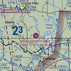
| Sectional chart |
|---|
|
| Airport distance calculator |
|---|
|
|
| Sunrise and sunset |
|---|
|
Times for 16-May-2026
| | Local
(UTC-5) | | Zulu
(UTC) |
|---|
| Morning civil twilight | | 04:45 | | 09:45 |
| Sunrise | | 05:21 | | 10:21 |
| Sunset | | 20:18 | | 01:18 |
| Evening civil twilight | | 20:54 | | 01:54 |
|
| Current date and time |
|---|
| Zulu (UTC) | 17-May-2026 04:15:37 |
|---|
| Local (UTC-5) | 16-May-2026 23:15:37 |
|---|
|
| METAR |
|---|
KIMT
13nm SE | 170354Z AUTO 36004KT 10SM CLR 11/03 A2992 RMK AO2 SLP133 T01060033
|
|
| TAF |
|---|
KSAW
42nm NE | 162147Z 1622/1718 05012KT P6SM SKC FM170300 01007KT P6SM FEW240 FM171200 06007KT P6SM BKN240
|
|
| NOTAMs |
|---|
NOTAMs are issued by the DoD/FAA and will open in a separate window not controlled by AirNav.
|
|

