FAA INFORMATION EFFECTIVE 16 APRIL 2026
Location
| FAA Identifier: | 5NC2 |
| Lat/Long: | 35-59-05.5000N 080-30-41.1000W
35-59.091667N 080-30.685000W
35.9848611,-80.5114167
(estimated) |
| Elevation: | 731 ft. / 222.8 m (surveyed) |
| Variation: | 06W (1985) |
| From city: | 6 miles NE of MOCKSVILLE, NC |
| Time zone: | UTC -4 (UTC -5 during Standard Time) |
| Zip code: | 27028 |
Airport Operations
| Airport use: | Private use. Permission required prior to landing |
| Activation date: | 04/1970 |
| Control tower: | no |
| ARTCC: | ATLANTA CENTER |
| FSS: | RALEIGH FLIGHT SERVICE STATION |
| Attendance: | ALL/MON-WED, FRI/0930-1530, ALL/THU, SAT/0930-1230, ALL SUN 1300-1530
CLSD THU AND SAT AT 1230. CLOSED ON MAJOR HOLS. |
| Pattern altitude: | 1500 ft. MSL |
| Wind indicator: | lighted |
| Segmented circle: | no |
| Lights: | TO ACTVT LIRL RWY 02L/20R, KEY 123.00 5 TIMES. THLD, RWY END ID LGTS OTS. |
Airport Communications
| UNICOM: | 123.0 |
| WX AWOS-3 at EXX (16 nm SE): | 119.825 (336-956-2967) |
| WX ASOS at INT (17 nm NE): | PHONE 336-661-3096 |
Nearby radio navigation aids
| VOR radial/distance | | VOR name | | Freq | | Var |
|---|
| GSOr265/26.2 | | GREENSBORO VORTAC | | 116.20 | | 03W |
| BZMr085/36.1 | | BARRETTS MOUNTAIN VOR/DME | | 113.75 | | 06W |
Airport Services
| Parking: | tiedowns |
| Airframe service: | NONE |
| Powerplant service: | NONE |
| Bottled oxygen: | NONE |
| Bulk oxygen: | NONE |
Runway Information
Runway 2L/20R
| Dimensions: | 2424 x 36 ft. / 739 x 11 m |
| Surface: | asphalt, in good condition |
| Runway edge lights: | non-standard
NSTD LIRL; NOT FAA APVD L-800 SERIES. THLD LGTS 13 FT FM PAVEMENT. |
| Runway edge markings: | RWY 02L/20R NRS ARE SMLR THAN STD. |
| RUNWAY 2L | | RUNWAY 20R |
| Latitude: | 35-58.894175N | | 35-59.287968N |
| Longitude: | 080-30.726007W | | 080-30.642330W |
| Elevation: | 716.0 ft. | | 720.0 ft. |
| Traffic pattern: | right | | left |
| Runway heading: | 016 magnetic, 010 true | | 196 magnetic, 190 true |
| Markings: | NSTD, in fair condition | | NSTD, in fair condition |
| Runway end identifier lights: | no | | no |
| Obstructions: | 60 ft. trees, 660 ft. from runway, 58 ft. right of centerline, 7:1 slope to clear | | 60 ft. trees, 200 ft. from runway
RWY 20R HAS 60 FT TREES 50 FT FM THLD ON CNTRLN. |
Runway 2R/20L
| Dimensions: | 1000 x 35 ft. / 305 x 11 m |
| Surface: | turf, in good condition |
| RUNWAY 2R | | RUNWAY 20L |
| Traffic pattern: | right | | left |
| Obstructions: | 60 ft. trees, 1500 ft. from runway | | 60 ft. trees, 900 ft. from runway |
Airport Ownership and Management from official FAA records
| Ownership: | Privately-owned |
| Owner: | HUMAN SERVICE ALLIANCE, INC.
249 GILBERT ROAD
MOCKSVILLE, NC 27028
Phone 336-998-3971 |
| Manager: | SANDRA SMITH
245 GILBERT ROAD
MOCKSVILLE, NC 27028
Phone 336-998-3971 |
Additional Remarks
| - | RCMD LNDG RWY 02L AND TKOF RWY 20R DUE TO OBSTNG TREES ON NE END. |
| - | RWY 02L/20R SAFETY AREA HAS HAZUS DEPRESSIONS AS CLOSE AS 15 FT FROM PAVEMENT. |
| - | ARPT CLSD TO TSNT ACFT 1800-0600. |
| - | DAY VFR OPNS FOR TSNT ACFT ONLY. |
| - | FOR CD CTC GREENSBORO APCH AT 743-222-6129. |
| - | WILDLIFE ON & INVOF ARPT. |
| - | MOWING OPS ON & INVOF ARPT. |
Instrument Procedures
There are no published instrument procedures at 5NC2.
Some nearby airports with instrument procedures:
8A7 - Twin Lakes Airport (5 nm SE)
KEXX - Davidson County Executive Airport (16 nm SE)
KINT - Smith Reynolds Airport (17 nm NE)
KRUQ - Mid-Carolina Regional Airport (20 nm S)
KZEF - Elkin Municipal Airport (22 nm NW)
|
|

Road maps at:
MapQuest
Bing
Google
| Aerial photo |
|---|
WARNING: Photo may not be current or correct
 Photo by Deborah Leighton
Taken in 2015
looking southwest
Photo by Deborah Leighton
Taken in 2015
looking southwest
Do you have a better or more recent aerial photo of Sugar Valley Airport that you would like to share? If so, please send us your photo.
|
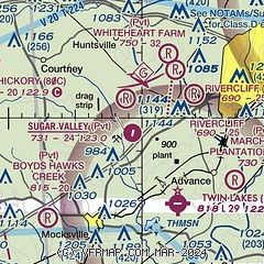
| Sectional chart |
|---|
|
| Airport distance calculator |
|---|
|
|
| Sunrise and sunset |
|---|
|
Times for 23-Apr-2026
| | Local
(UTC-4) | | Zulu
(UTC) |
|---|
| Morning civil twilight | | 06:13 | | 10:13 |
| Sunrise | | 06:40 | | 10:40 |
| Sunset | | 20:01 | | 00:01 |
| Evening civil twilight | | 20:28 | | 00:28 |
|
| Current date and time |
|---|
| Zulu (UTC) | 23-Apr-2026 04:43:25 |
|---|
| Local (UTC-4) | 23-Apr-2026 00:43:25 |
|---|
|
| METAR |
|---|
KEXX
16nm SE | 230415Z AUTO 00000KT 10SM CLR 17/08 A3007 RMK AO2 T01660081
|
KRUQ
20nm S | 230415Z AUTO 18003KT 10SM CLR 12/07 A3007 RMK AO2 T01210066
|
KSVH
26nm SW | 230415Z AUTO 36003KT 10SM CLR 14/05 A3009 RMK AO2 T01430054
|
KGSO
28nm E | 230354Z 17003KT 10SM BKN120 18/09 A3006 RMK AO2 SLP171 T01780089
|
KMWK
29nm N | 230415Z AUTO 06001KT 10SM CLR 14/09 A3010 RMK AO2
|
|
| TAF |
|---|
KINT
17nm NE | 221720Z 2218/2318 25011G20KT P6SM SCT250 FM222300 28006KT P6SM SCT100 AMD NOT SKED
|
|
| NOTAMs |
|---|
NOTAMs are issued by the DoD/FAA and will open in a separate window not controlled by AirNav.
|
|

