FAA INFORMATION EFFECTIVE 09 JULY 2026
Location
| FAA Identifier: | 81B |
| Lat/Long: | 44-09-26.8000N 070-28-52.6000W
44-09.446667N 070-28.876667W
44.1574444,-70.4812778
(estimated) |
| Elevation: | 345 ft. / 105.2 m (surveyed) |
| Variation: | 17W (1995) |
| From city: | 2 miles E of OXFORD, ME |
| Time zone: | UTC -4 (UTC -5 during Standard Time) |
| Zip code: | 04270 |
Airport Operations
| Airport use: | Open to the public |
| Activation date: | 11/1973 |
| Sectional chart: | (ADDNL SECTIONAL CHART NEW YORK.) |
| Control tower: | no |
| ARTCC: | BOSTON CENTER |
| FSS: | BANGOR FLIGHT SERVICE STATION |
| NOTAMs facility: | BGR (NOTAM-D service available) |
| Attendance: | MON-SAT 0700-1700, ALL SUN UNATNDD |
| Wind indicator: | lighted |
| Segmented circle: | yes |
| Lights: | ACTVT MIRL RWY 15/33 - CTAF. |
| Beacon: | white-green (lighted land airport)
Operates sunset to sunrise. |
Airport Communications
| CTAF/UNICOM: | 122.8 |
| PORTLAND APPROACH: | 125.5 |
| PORTLAND DEPARTURE: | 125.5 |
| WX AWOS-3PT at LEW (11 nm SE): | 118.025 (207-783-2806) |
- APCH/DEP SVC PRVDD BY BOSTON ARTCC ON FREQS 128.2/263.05 (WATERBORO RCAG) WHEN PORTLAND APCH CTL IS CLSD.
Nearby radio navigation aids
| VOR radial/distance | | VOR name | | Freq | | Var |
|---|
| AUGr270/31.0 | | AUGUSTA VOR/DME | | 114.95 | | 18W |
Airport Services
| Fuel available: | 100LL
100LL:SELF-SVC 100LL AVBL 24 HRS. |
| Parking: | hangars and tiedowns |
| Airframe service: | MAJOR
FOR MAINT CALL 207-539-6065. |
| Powerplant service: | MAJOR
FOR MAINT CALL 207-539-6065. |
| Bottled oxygen: | HIGH/LOW |
| Bulk oxygen: | HIGH/LOW |
Runway Information
Runway 15/33
| Dimensions: | 2997 x 75 ft. / 913 x 23 m |
| Surface: | asphalt, in good condition |
| Weight bearing capacity: | |
| Runway edge lights: | medium intensity |
| RUNWAY 15 | | RUNWAY 33 |
| Latitude: | 44-09.609142N | | 44-09.282362N |
| Longitude: | 070-29.133748W | | 070-28.620627W |
| Elevation: | 345.0 ft. | | 337.3 ft. |
| Traffic pattern: | left | | left |
| Runway heading: | 149 magnetic, 132 true | | 329 magnetic, 312 true |
| Markings: | nonprecision, in fair condition | | nonprecision, in fair condition |
| Touchdown point: | yes, no lights | | yes, no lights |
Airport Ownership and Management from official FAA records
| Ownership: | Publicly-owned |
| Owner: | OXFORD COUNTY
PO BOX 179, 26 WESTERN AVE
SOUTH PARIS, ME 04281
Phone 207-461-5040
EMERG FONE: 207-743-6336 OXFORD COUNTY EMA. |
| Manager: | TONY CARTER - CO ADMIR
PO BOX 179, 26 WESTERN AVE
SOUTH PARIS, ME 04281
Phone 207-461-5040 |
Additional Remarks
| - | RWY 15/33 HAS 2 IN DROP-OFFS LCTD ON ALL SIDES & THLDS. |
| - | WILDLIFE ON & INVOF ARPT. |
| - | FOR CD CTC PORTLAND APCH AT 207-874-7320, WHEN APCH CLSD CTC BOSTON ARTCC AT 603-879-6859. |
| A58-15 | 6-10 FT TREES, 75-125 FT FM THR, 170-185 FT RITE OF CNTRLN. |
Instrument Procedures
NOTE: All procedures below are presented as PDF files. If you need a reader for these files, you should download the free Adobe Reader.NOT FOR NAVIGATION. Please procure official charts for flight.
FAA instrument procedures published for use from 09 July 2026 at 0901Z to 06 August 2026 at 0900Z.
IAPs - Instrument Approach Procedures |
|---|
| RNAV (GPS) RWY 15 | |
download (207KB) |
| RNAV (GPS) RWY 33 | |
download (208KB) |
| NOTE: Special Take-Off Minimums/Departure Procedures apply | |
download (178KB) |
Other nearby airports with instrument procedures:
KLEW - Auburn/Lewiston Municipal Airport (11 nm SE)
0B1 - Bethel Regional Airport (21 nm NW)
KIZG - White Mountain Regional Airport (22 nm SW)
KBXM - Brunswick Executive Airport (28 nm SE)
KAUG - Augusta State Airport (31 nm E)
|
|

Road maps at:
MapQuest
Bing
Google
| Aerial photo |
|---|
WARNING: Photo may not be current or correct
 Photo by Steven F. Hyde, Skyhaven Flying Club
Photo taken 07-Sep-2012
looking northwest.
Photo by Steven F. Hyde, Skyhaven Flying Club
Photo taken 07-Sep-2012
looking northwest.
Do you have a better or more recent aerial photo of Oxford County Regional Airport that you would like to share? If so, please send us your photo.
|
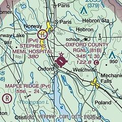
| Sectional chart |
|---|
|
| Airport distance calculator |
|---|
|
|
| Sunrise and sunset |
|---|
|
Times for 26-Jul-2026
| | Local
(UTC-4) | | Zulu
(UTC) |
|---|
| Morning civil twilight | | 04:50 | | 08:50 |
| Sunrise | | 05:24 | | 09:24 |
| Sunset | | 20:13 | | 00:13 |
| Evening civil twilight | | 20:46 | | 00:46 |
|
| Current date and time |
|---|
| Zulu (UTC) | 26-Jul-2026 06:25:06 |
|---|
| Local (UTC-4) | 26-Jul-2026 02:25:06 |
|---|
|
| METAR |
|---|
KLEW
12nm SE | 260556Z AUTO 00000KT 10SM CLR 10/09 A3000 RMK AO2 SLP165 6//// T01000094 10206 20100 PNO $
|
KIZG
23nm SW | 260554Z AUTO 00000KT 10SM CLR 11/09 A3000 RMK AO2 SLP160 T01060089 10222 20106 56017 $
|
|
| TAF |
|---|
KAUG
31nm E | 260520Z 2606/2706 VRB03KT P6SM SCT250
|
KPWM
31nm S | 251736Z 2518/2618 16008KT P6SM FEW250 FM260000 VRB03KT P6SM SCT250
|
|
| NOTAMs |
|---|
NOTAMs are issued by the DoD/FAA and will open in a separate window not controlled by AirNav.
|
|

