FAA INFORMATION EFFECTIVE 14 MAY 2026
Location
| FAA Identifier: | 8A1 |
| Lat/Long: | 34-24-22.2811N 086-15-39.1330W
34-24.371352N 086-15.652217W
34.4061892,-86.2608703
(estimated) |
| Elevation: | 614.6 ft. / 187.3 m (surveyed) |
| Variation: | 04W (2020) |
| From city: | 3 miles NE of GUNTERSVILLE, AL |
| Time zone: | UTC -5 (UTC -6 during Standard Time) |
| Zip code: | 35976 |
Airport Operations
| Airport use: | Open to the public |
| Activation date: | 11/1951 |
| Control tower: | no |
| ARTCC: | MEMPHIS CENTER |
| FSS: | ANNISTON FLIGHT SERVICE STATION |
| NOTAMs facility: | ANB (NOTAM-D service available) |
| Attendance: | MON - SAT 0800-1700
MGR ON CALL AFT HRS.
CALL OUT SVC AVBL 256-582-6087. |
| Wind indicator: | yes |
| Segmented circle: | yes |
| Lights: | ACTVT REIL RWY 7 & 25; PAPI RWY 25; MIRL RWY 7/25 - CTAF. |
| Beacon: | white-green (lighted land airport)
Operates sunset to sunrise. |
Airport Communications
| CTAF/UNICOM: | 122.8 |
| WX AWOS-3PT: | 121.125 |
| HUNTSVILLE APPROACH: | 125.6 |
| HUNTSVILLE DEPARTURE: | 125.6 |
| WX AWOS-3PT at BFZ (11 nm S): | 119.575 (256-891-8259) |
- APCH/DEP SVC PRVDD BY MEMPHIS ARTCC ON FREQS 120.8/307.0 (HUNTSVILLE RCAG) WHEN HUNTSVILLE APCH CTL CLSD.
Nearby radio navigation aids
| VOR radial/distance | | VOR name | | Freq | | Var |
|---|
| GADr339/27.2 | | GADSDEN VOR/DME | | 112.30 | | 02E |
| RQZr140/29.8 | | ROCKET VORTAC | | 112.20 | | 02E |
Airport Services
| Fuel available: | 100LL JET-A+
100LL:24/7 SELF-SVC AVGAS & FULL SVC JET-A DURNG NML OPN HRS. |
| Parking: | tiedowns |
| Airframe service: | MAJOR |
| Powerplant service: | MAJOR |
| Bottled oxygen: | NONE |
| Bulk oxygen: | NONE |
Runway Information
Runway 7/25
| Dimensions: | 5005 x 75 ft. / 1526 x 23 m |
| Surface: | asphalt/grooved, in good condition |
| Weight bearing capacity: | |
| Runway edge lights: | medium intensity |
| RUNWAY 7 | | RUNWAY 25 |
| Latitude: | 34-24.011412N | | 34-24.356972N |
| Longitude: | 086-16.266930W | | 086-15.362888W |
| Elevation: | 610.0 ft. | | 614.6 ft. |
| Traffic pattern: | left | | left |
| Runway heading: | 069 magnetic, 065 true | | 249 magnetic, 245 true |
| Markings: | nonprecision, in good condition | | nonprecision, in good condition |
| Visual slope indicator: | | | 2-light PAPI on left (3.35 degrees glide path) |
| Runway end identifier lights: | yes | | yes |
| Touchdown point: | yes, no lights | | yes, no lights |
| Obstructions: | 45 ft. tree, 604 ft. from runway, 290 ft. right of centerline, 8:1 slope to clear | | 22 ft. trees, 842 ft. from runway, 90 ft. right of centerline, 29:1 slope to clear |
Runway 6W/24W
| Dimensions: | 5500 x 200 ft. / 1676 x 61 m |
| Surface: | water |
| RUNWAY 6W | | RUNWAY 24W |
| Latitude: | 34-24.350000N | | 34-24.733333N |
| Longitude: | 086-16.000000W | | 086-15.008333W |
| Elevation: | 595.0 ft. | | 595.0 ft. |
| Traffic pattern: | left | | left |
| Runway heading: | 069 magnetic, 065 true | | 249 magnetic, 245 true |
| Touchdown point: | yes, no lights | | yes, no lights |
Airport Ownership and Management from official FAA records
| Ownership: | Publicly-owned |
| Owner: | CITY OF GUNTERSVILLE
341 GUNTER AVE
GUNTERSVILLE, AL 35976
Phone 256-571-7560 |
| Manager: | GARY MCILQUHAM
405 BUCK ISLAND RD
GUNTERSVILLE, AL 35976
Phone (256) 582-6087 |
Additional Remarks
| - | DEER, BIRDS, AND COYOTES ON & INVOF ARPT. |
| - | FOR CD CTC HUNTSVILLE APCH AT 256-542-2070, WHEN APCH CLSD CTC MEMPHIS ARTCC AT 901-368-8453/8449. |
Instrument Procedures
NOTE: All procedures below are presented as PDF files. If you need a reader for these files, you should download the free Adobe Reader.NOT FOR NAVIGATION. Please procure official charts for flight.
FAA instrument procedures published for use from 14 May 2026 at 0901Z to 11 June 2026 at 0900Z.
IAPs - Instrument Approach Procedures |
|---|
| RNAV (GPS) RWY 07 | |
download (215KB) |
| RNAV (GPS) RWY 25 | |
download (218KB) |
| NOTE: Special Alternate Minimums apply | |
download (156KB) |
| NOTE: Special Take-Off Minimums/Departure Procedures apply | |
download (479KB) |
Other nearby airports with instrument procedures:
KBFZ - Albertville Regional Airport-Thomas J Brumlik Field (11 nm S)
4A6 - Scottsboro Municipal Airport-Word Field (21 nm NE)
KHUA - Redstone Army Airfield (27 nm NW)
20A - Robbins Field Airport (27 nm S)
4A9 - Isbell Field Airport (27 nm E)
|
|

Road maps at:
MapQuest
Bing
Google
| Aerial photo |
|---|
WARNING: Photo may not be current or correct
 Photo by Marty Sellers sellersphoto.com
Photo taken 01-Oct-2020
looking west.
Photo by Marty Sellers sellersphoto.com
Photo taken 01-Oct-2020
looking west.
Do you have a better or more recent aerial photo of Guntersville Municipal Airport - Joe Starnes Field that you would like to share? If so, please send us your photo.
|
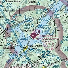
| Sectional chart |
|---|
|
| Airport distance calculator |
|---|
|
|
| Sunrise and sunset |
|---|
|
Times for 05-Jun-2026
| | Local
(UTC-5) | | Zulu
(UTC) |
|---|
| Morning civil twilight | | 05:05 | | 10:05 |
| Sunrise | | 05:34 | | 10:34 |
| Sunset | | 19:53 | | 00:53 |
| Evening civil twilight | | 20:22 | | 01:22 |
|
| Current date and time |
|---|
| Zulu (UTC) | 05-Jun-2026 22:32:38 |
|---|
| Local (UTC-5) | 05-Jun-2026 17:32:38 |
|---|
|
| METAR |
|---|
KBFZ
11nm S | 052215Z AUTO 18004KT 10SM CLR 27/16 A3010 RMK AO2
|
K4A6
21nm NE | 052215Z AUTO 00000KT 10SM CLR 27/17 A3009 RMK AO2
|
|
| TAF |
|---|
KHSV
30nm NW | 051720Z 0518/0618 18010G17KT P6SM FEW040 SCT250 FM060000 16003KT P6SM FEW150 BKN250 FM061500 16007KT P6SM FEW040 BKN250
|
|
| NOTAMs |
|---|
NOTAMs are issued by the DoD/FAA and will open in a separate window not controlled by AirNav.
|
|

