FAA INFORMATION EFFECTIVE 19 MARCH 2026
Location
| FAA Identifier: | AIK |
| Lat/Long: | 33-38-57.8000N 081-41-06.1000W
33-38.963333N 081-41.101667W
33.6493889,-81.6850278
(estimated) |
| Elevation: | 528.5 ft. / 161.1 m (surveyed) |
| Variation: | 06W (2010) |
| From city: | 5 miles N of AIKEN, SC |
| Time zone: | UTC -4 (UTC -5 during Standard Time) |
| Zip code: | 29805 |
Airport Operations
| Airport use: | Open to the public |
| Activation date: | 01/1943 |
| Control tower: | no |
| ARTCC: | ATLANTA CENTER |
| FSS: | ANDERSON FLIGHT SERVICE STATION |
| NOTAMs facility: | AND (NOTAM-D service available) |
| Attendance: | 0700-1900 |
| Wind indicator: | yes |
| Segmented circle: | yes |
| Lights: | ACTVT ODALS RWY 25; MIRL RWY 07/25 - CTAF. PAPI RWY 07 & 25 OPER CONSLY. |
| Beacon: | white-green (lighted land airport)
Operates sunset to sunrise. |
Airport Communications
| CTAF/UNICOM: | 122.8 |
| WX AWOS-3PT: | 118.025 (803-643-8664) |
| AUGUSTA APPROACH: | 119.15 124.15 [SUN-FRI 0530-0030 SAT 0530-0000] |
| AUGUSTA DEPARTURE: | 119.15 124.15 [SUN-FRI 0530-0030 SAT 0530-0000] |
| CLEARANCE DELIVERY: | 126.075 126.075 ;WHEN AUGUSTA APCH CTL CLSD |
- APCH/DEP SVC PRVDD BY COLUMBIA APCH CTL ON FREQS 124.15/338.2 WHEN AUGUSTA APCH CTL CLSD.
Nearby radio navigation aids
| VOR radial/distance | | VOR name | | Freq | | Var |
|---|
| IRQr102/24.1 | | COLLIERS VORTAC | | 113.90 | | 04W |
| CAEr250/33.9 | | COLUMBIA VORTAC | | 114.70 | | 02W |
| NDB name | | Hdg/Dist | | Freq | | Var | | ID |
|---|
| AIKEN | | at field | | 347 | | 06W | | AIK | .- .. -.- |
| EMORY | | 058/19.2 | | 385 | | 04W | | EMR | . -- .-. |
Airport Services
| Fuel available: | 100LL JET-A |
| Parking: | hangars and tiedowns |
| Airframe service: | MINOR |
| Powerplant service: | MINOR |
| Bottled oxygen: | NONE |
| Bulk oxygen: | NONE |
Runway Information
Runway 7/25
| Dimensions: | 5500 x 100 ft. / 1676 x 30 m |
| Surface: | asphalt, in good condition |
| Weight bearing capacity: | | PCN 21 /F/C/X/T | | Single wheel: | 55.0 | | Double wheel: | 75.0 | | Double tandem: | 140.0 |
|
| Runway edge lights: | medium intensity |
| RUNWAY 7 | | RUNWAY 25 |
| Latitude: | 33-38.764260N | | 33-39.213125N |
| Longitude: | 081-41.746903W | | 081-40.804790W |
| Elevation: | 514.6 ft. | | 493.5 ft. |
| Traffic pattern: | left | | left |
| Runway heading: | 066 magnetic, 060 true | | 246 magnetic, 240 true |
| Markings: | precision, in good condition | | nonprecision, in good condition |
| Visual slope indicator: | 2-light PAPI on left (3.00 degrees glide path) | | 2-light PAPI on left (3.00 degrees glide path) |
| Approach lights: | | | ODALS: omnidirectional approach lighting system |
| Runway end identifier lights: | | | yes |
| Touchdown point: | yes, no lights | | yes, no lights |
| Instrument approach: | ILS/DME | | |
Runway 1/19
| Dimensions: | 3800 x 75 ft. / 1158 x 23 m |
| Surface: | asphalt/aggregate friction seal coat, in fair condition |
| Weight bearing capacity: | | PCN 20 /F/C/X/T | | Single wheel: | 54.0 | | Double wheel: | 75.0 | | Double tandem: | 139.0 |
|
| RUNWAY 1 | | RUNWAY 19 |
| Latitude: | 33-38.611430N | | 33-39.237908N |
| Longitude: | 081-40.853377W | | 081-40.848475W |
| Elevation: | 528.1 ft. | | 492.9 ft. |
| Traffic pattern: | left | | left |
| Runway heading: | 006 magnetic, 000 true | | 186 magnetic, 180 true |
| Markings: | basic, in good condition | | basic, in good condition |
| Touchdown point: | yes, no lights | | yes, no lights |
| Obstructions: | 55 ft. tree, 574 ft. from runway, 119 ft. right of centerline, 6:1 slope to clear | | none |
Airport Ownership and Management from official FAA records
| Ownership: | Publicly-owned |
| Owner: | CITY OF AIKEN
PO BOX 1177
AIKEN, SC 29801
Phone (803) 642-7654 |
| Manager: | CHRISTOPHER MCCAULEY
129 AVIATION BLVD, 214 PARK AVENUE, SW
AIKEN, SC 29805
Phone 803-502-4860 |
Additional Remarks
| - | FOR CD IF UNA TO CTC ON FSS FREQ, CTC AUGUSTA APCH AT 706-771-1777, WHEN APCH CLSD CTC COLUMBIA APCH AT 803-822-4511. |
Instrument Procedures
NOTE: All procedures below are presented as PDF files. If you need a reader for these files, you should download the free Adobe Reader.NOT FOR NAVIGATION. Please procure official charts for flight.
FAA instrument procedures published for use from 19 March 2026 at 0901Z to 16 April 2026 at 0900Z.
IAPs - Instrument Approach Procedures |
|---|
| ILS OR LOC/DME RWY 07 | |
download (266KB) |
| RNAV (GPS) RWY 07 **CHANGED** | |
download (270KB) |
| RNAV (GPS) RWY 25 | |
download (276KB) |
Departure Procedures |
|---|
| CHATT SIX (RNAV) | |
download (190KB) |
| DOVER FIVE (RNAV) | |
download (179KB) |
| JUNPR SIX (RNAV) | |
download (159KB) |
| KAOLN SIX (RNAV) | |
download (172KB) |
| RDBUD FOUR (RNAV) | |
download (176KB) |
| SAMMI FOUR (RNAV) | |
download (161KB) |
| NOTE: Special Take-Off Minimums/Departure Procedures apply | |
download (275KB) |
Other nearby airports with instrument procedures:
6J4 - Saluda County Airport (18 nm N)
KDNL - Daniel Field Airport (21 nm SW)
KAGS - Augusta Regional Airport at Bush Field (22 nm SW)
6J0 - Lexington County Airport (24 nm E)
KBNL - Barnwell Regional Airport (28 nm SE)
|
|

Road maps at:
MapQuest
Bing
Google
| Aerial photo |
|---|
WARNING: Photo may not be current or correct
 Photo courtesy of AirNav, LLC
Photo taken 03-Jul-2010
Photo courtesy of AirNav, LLC
Photo taken 03-Jul-2010
Do you have a better or more recent aerial photo of Aiken Regional Airport that you would like to share? If so, please send us your photo.
|
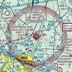
| Sectional chart |
|---|
|
| Airport distance calculator |
|---|
|
|
| Sunrise and sunset |
|---|
|
Times for 07-Apr-2026
| | Local
(UTC-4) | | Zulu
(UTC) |
|---|
| Morning civil twilight | | 06:42 | | 10:42 |
| Sunrise | | 07:07 | | 11:07 |
| Sunset | | 19:50 | | 23:50 |
| Evening civil twilight | | 20:16 | | 00:16 |
|
| Current date and time |
|---|
| Zulu (UTC) | 07-Apr-2026 15:38:00 |
|---|
| Local (UTC-4) | 07-Apr-2026 11:38:00 |
|---|
|
| METAR |
|---|
| KAIK | 071515Z AUTO 04010KT 10SM CLR 19/06 A3024 RMK AO2 T01860055
|
|
| TAF |
|---|
| KAIK | 071418Z 0714/0812 04008KT P6SM BKN250 FM071500 05011G19KT P6SM SCT250 FM072300 04008KT P6SM FEW250
|
|
| NOTAMs |
|---|
NOTAMs are issued by the DoD/FAA and will open in a separate window not controlled by AirNav.
|
|


