FAA INFORMATION EFFECTIVE 14 MAY 2026
Location
| FAA Identifier: | AQW |
| Lat/Long: | 42-41-46.5137N 073-10-13.9910W
42-41.775228N 073-10.233183W
42.6962538,-73.1705531
(estimated) |
| Elevation: | 653.8 ft. / 199.3 m (surveyed) |
| Variation: | 14W (1985) |
| From city: | 3 miles W of NORTH ADAMS, MA |
| Time zone: | UTC -4 (UTC -5 during Standard Time) |
| Zip code: | 01247 |
Airport Operations
| Airport use: | Open to the public |
| Activation date: | 10/1944 |
| Control tower: | no |
| ARTCC: | BOSTON CENTER |
| FSS: | BURLINGTON FLIGHT SERVICE STATION |
| NOTAMs facility: | AQW (NOTAM-D service available) |
| Attendance: | IREG |
| Wind indicator: | lighted |
| Segmented circle: | no |
| Lights: | ACTVT MIRL RWY 11/29 - CTAF. |
| Beacon: | white-green (lighted land airport)
Operates sunset to sunrise. |
| Landing fee: | yes, CTC AMGR FOR LNDG FEES. |
Airport Communications
| CTAF/UNICOM: | 122.8 |
| WX ASOS: | 134.775 (413-664-6658) |
| ALBANY APPROACH: | 132.825 |
| ALBANY DEPARTURE: | 132.825 |
| WX ASOS at DDH (12 nm N): | 135.925 (802-442-6059) |
| WX ASOS at PSF (17 nm S): | 135.375 (413-499-3273) |
- APCH/DEP SVC PRVDD BY ALBANY (ALB) APCH CTL 132.8/307.2.
Nearby radio navigation aids
| VOR radial/distance | | VOR name | | Freq | | Var |
|---|
| CAMr171/19.4 | | CAMBRIDGE VOR/DME | | 115.00 | | 14W |
| CTRr351/26.2 | | CHESTER VOR/DME | | 115.10 | | 13W |
| ALBr109/28.1 | | ALBANY VORTAC | | 115.30 | | 13W |
| BAFr342/37.8 | | BARNES VORTAC | | 113.00 | | 14W |
| NDB name | | Hdg/Dist | | Freq | | Var | | ID |
|---|
| HUNTER | | 120/34.9 | | 356 | | 14W | | HEU | .... . ..- |
Airport Services
| Fuel available: | 100LL JET-A |
| Parking: | tiedowns |
| Airframe service: | MAJOR |
| Powerplant service: | MAJOR |
| Bottled oxygen: | HIGH |
Runway Information
Runway 11/29
| Dimensions: | 4300 x 100 ft. / 1311 x 30 m |
| Surface: | asphalt, in excellent condition |
| Weight bearing capacity: | |
| Runway edge lights: | medium intensity |
| RUNWAY 11 | | RUNWAY 29 |
| Latitude: | 42-41.815700N | | 42-41.734755N |
| Longitude: | 073-10.709877W | | 073-09.756488W |
| Elevation: | 652.0 ft. | | 653.8 ft. |
| Traffic pattern: | left | | right |
| Runway heading: | 111 magnetic, 097 true | | 291 magnetic, 277 true |
| Displaced threshold: | 500 ft. | | 100 ft. |
| Markings: | basic, in good condition | | basic, in good condition |
| Runway end identifier lights: | no | | no |
| Touchdown point: | yes, no lights | | yes, no lights |
| Obstructions: | 62 ft. trees, 920 ft. from runway, 80 ft. left of centerline, 11:1 slope to clear
APCH RATIO 20:1 TO DTHR. | | 25 ft. bldg, 340 ft. from runway, 130 ft. right of centerline, 6:1 slope to clear
APCH RATIO 20:1 TO DTHR. |
Airport Ownership and Management from official FAA records
| Ownership: | Publicly-owned |
| Owner: | CITY OF NORTH ADAMS
10 MAIN ST - CITY HALL
NORTH ADAMS, MA 01247
Phone 413-662-3000 |
| Manager: | ANDREW FRANKLIN
10 MAIN ST - CITY HALL
NORTH ADAMS, MA 01247
Phone 413-652-7735 |
Additional Remarks
| - | MT RANGES 9100 FT N AT ELEV 1894 FT; 4300 FT N AT ELEV 2254 FT; 10800 FT S AT ELEV 2951 FT; 12800 FT S AT ELEV 2690 FT. |
| - | RWY 11 LEFT TFC FOR PWRD ACFT. RWY 11 RIGHT TFC FOR GLD AND TOW PLANE. |
| - | EXTSV GLDR OPS DAWN-DUSK SFC-18000 FT YEAR ROUND; PRIMARILY WKENDS & HOLS. |
| - | RWY 29 RIGHT TFC FOR PWRD ACFT. RWY 29 LEFT TFC FOR GLD AND TOW PLANE. |
| - | WILDLIFE ON & INVOF ARPT. |
| - | FOR CD CTC ALBANY APCH AT 518-862-2299. |
| - | TWY A2 REMOVED. |
| - | PILOTS LDG ON RWY 29 ARE ENCOURAGED TO AVOID LOW APCHS, IF SAFE TO DO SO, OVR THE RES NBRHD JUST E OF THE ARPT. |
Instrument Procedures
NOTE: All procedures below are presented as PDF files. If you need a reader for these files, you should download the free Adobe Reader.NOT FOR NAVIGATION. Please procure official charts for flight.
FAA instrument procedures published for use from 14 May 2026 at 0901Z to 11 June 2026 at 0900Z.
IAPs - Instrument Approach Procedures |
|---|
| RNAV (GPS)-A | |
download (201KB) |
| RNAV (GPS)-B | |
download (169KB) |
| NOTE: Special Alternate Minimums apply | |
download (48KB) |
| NOTE: Special Take-Off Minimums/Departure Procedures apply | |
download (252KB) |
Other nearby airports with instrument procedures:
KDDH - William H Morse State Airport (12 nm N)
KPSF - Pittsfield Municipal Airport (17 nm S)
KALB - Albany International Airport (28 nm W)
0B5 - Turners Falls Airport (29 nm E)
4B0 - South Albany Airport (30 nm W)
|
|

Road maps at:
MapQuest
Bing
Google
| Aerial photo |
|---|
WARNING: Photo may not be current or correct

Do you have a better or more recent aerial photo of Harriman-and-West Airport that you would like to share? If so, please send us your photo.
|
| Sectional chart |
|---|
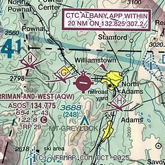
|
| Airport distance calculator |
|---|
|
|
| Sunrise and sunset |
|---|
|
Times for 10-Jun-2026
| | Local
(UTC-4) | | Zulu
(UTC) |
|---|
| Morning civil twilight | | 04:41 | | 08:41 |
| Sunrise | | 05:15 | | 09:15 |
| Sunset | | 20:29 | | 00:29 |
| Evening civil twilight | | 21:04 | | 01:04 |
|
| Current date and time |
|---|
| Zulu (UTC) | 11-Jun-2026 01:44:03 |
|---|
| Local (UTC-4) | 10-Jun-2026 21:44:03 |
|---|
|
| METAR |
|---|
| KAQW | 110052Z AUTO VRB03KT 10SM OVC065 26/19 A2975 RMK AO2 LTG DSNT N SLP069 T02610194
|
KDDH
12nm N | 110116Z AUTO 00000KT 6SM BR FEW017 BKN041 OVC050 22/22 A2976 RMK AO2 LTG DSNT NE RAE04 TSB0055E10 P0000 T02220217
|
KPSF
17nm S | 110054Z AUTO 22008KT 10SM FEW060 24/19 A2978 RMK AO2 SLP056 T02390189
|
|
| TAF |
|---|
KPSF
17nm S | 110015Z 1100/1124 22008KT P6SM BKN050 TEMPO 1101/1103 VRB15G25KT 3SM SHRA BR BKN035 FM110300 VRB03KT 6SM BR SCT006 BKN040 FM110800 26004KT 5SM BR BKN006 FM111100 28006KT P6SM SCT008 BKN018 FM111400 29008KT P6SM SCT020 BKN035 FM111700 29012G18KT P6SM BKN050 PROB30 1122/1124 VRB15G25KT 4SM TSRA BR BKN035CB
|
|
| NOTAMs |
|---|
NOTAMs are issued by the DoD/FAA and will open in a separate window not controlled by AirNav.
|
|

