FAA INFORMATION EFFECTIVE 16 APRIL 2026
Location
| FAA Identifier: | AST |
| Lat/Long: | 46-09-28.7220N 123-52-43.0450W
46-09.478700N 123-52.717417W
46.1579783,-123.8786236
(estimated) |
| Elevation: | 14.7 ft. / 4.5 m (surveyed) |
| Variation: | 15E (2020) |
| From city: | 3 miles SW of ASTORIA, OR |
| Time zone: | UTC -7 (UTC -8 during Standard Time) |
| Zip code: | 97146 |
Airport Operations
| Airport use: | Open to the public |
| Activation date: | 07/1938 |
| Control tower: | no |
| ARTCC: | SEATTLE CENTER |
| FSS: | MC MINNVILLE FLIGHT SERVICE STATION |
| NOTAMs facility: | AST (NOTAM-D service available) |
| Attendance: | 0800-1700
FOR FUEL OUTSIDE NML WORKING HRS CTC FBO 503-298-7531. |
| Wind indicator: | lighted |
| Segmented circle: | yes |
| Lights: | ACTVT MIRL RWY 08/26 & RY 14/32, MALSR RWY 26 AND REIL RWY 08 - CTAF. |
| Beacon: | white-green (lighted land airport)
Operates sunset to sunrise. |
Airport Communications
| CTAF/UNICOM: | 122.8 |
| WX ASOS: | 135.375 (503-994-0014) |
- COMMUNICATIONS PRVDD BY MCMINNVILLE RADIO ON FREQ 122.3 (ASTORIA RCO).
- APCH/DEP CTL SVC PRVDD BY SEATTLE ARTCC (ZSE) ON FREQS 124.2/317.6 (NASSEL RCAG).
- USCG AVAILABLE ON 345.0
Nearby radio navigation aids
| VOR radial/distance | | VOR name | | Freq | | Var |
|---|
| AST at field | | ASTORIA VOR/DME | | 114.00 | | 15E |
Airport Services
| Fuel available: | 100LL JET-A JET-A+
100LL:MIL FUEL AVBL ON GEN AVN/FBO RAMP, US GOVT AIRCARD ACPTD. CTC ASTORIA MAINT CTL 171.35 15 MIN PRIOR TO ENTERING CG RAMP. C503-861-6288. |
| Parking: | tiedowns |
| Airframe service: | MAJOR |
| Powerplant service: | MINOR |
| Bottled oxygen: | NONE |
| Bulk oxygen: | NONE |
Runway Information
Runway 8/26
| Dimensions: | 5794 x 100 ft. / 1766 x 30 m |
| Surface: | asphalt |
| Weight bearing capacity: | | Single wheel: | 60.0 | | Double wheel: | 76.0 | | Double tandem: | 119.0 |
|
| Runway edge lights: | medium intensity |
| RUNWAY 8 | | RUNWAY 26 |
| Latitude: | 46-09.590055N | | 46-09.498852N |
| Longitude: | 123-53.384558W | | 123-52.019032W |
| Elevation: | 12.2 ft. | | 11.1 ft. |
| Traffic pattern: | left | | left |
| Runway heading: | 080 magnetic, 095 true | | 260 magnetic, 275 true |
| Displaced threshold: | 300 ft. | | 713 ft. |
| Declared distances: | TORA:5794 TODA:5794 ASDA:5194 LDA:4894 | | TORA:5794 TODA:5794 ASDA:5494 LDA:4780 |
| Markings: | nonprecision, in fair condition | | precision, in fair condition |
| Visual slope indicator: | 4-box VASI on left (3.00 degrees glide path) | | |
| Approach lights: | | | MALSR: 1,400 foot medium intensity approach lighting system with runway alignment indicator lights |
| Runway end identifier lights: | yes | | |
| Touchdown point: | yes, no lights | | yes, no lights |
| Instrument approach: | | | ILS |
| Obstructions: | 116 ft. tree, 3100 ft. from runway, 900 ft. right of centerline, 25:1 slope to clear | | 12 ft. fence, 200 ft. from runway, 50 ft. right of centerline
+4 FT LEVEE DIST 350 FT 500 FT R, +50:1 BASED ON DSPLCD THR. |
Runway 14/32
| Dimensions: | 4467 x 100 ft. / 1362 x 30 m |
| Surface: | asphalt, in excellent condition |
| Weight bearing capacity: | | Single wheel: | 60.0 | | Double wheel: | 76.0 | | Double tandem: | 119.0 |
|
| Runway edge lights: | medium intensity |
| RUNWAY 14 | | RUNWAY 32 |
| Latitude: | 46-09.722570N | | 46-09.064155N |
| Longitude: | 123-52.972745W | | 123-52.502705W |
| Elevation: | 11.6 ft. | | 14.5 ft. |
| Traffic pattern: | left | | left |
| Runway heading: | 139 magnetic, 154 true | | 319 magnetic, 334 true |
| Declared distances: | TORA:4467 TODA:4467 ASDA:4467 LDA:4467 | | TORA:4467 TODA:4467 ASDA:4467 LDA:4467 |
| Markings: | basic, in good condition | | basic, in good condition |
| Visual slope indicator: | 4-box VASI on left (3.00 degrees glide path) | | 4-light PAPI on left (4.00 degrees glide path) |
| Runway end identifier lights: | yes | | |
| Touchdown point: | yes, no lights | | yes, no lights |
| Obstructions: | 5 ft. berm, 200 ft. from runway
5 FT LEVEE 150 FT FROM RY END 250 FT L TO 250 FT R. | | none |
Airport Ownership and Management from official FAA records
| Ownership: | Publicly-owned |
| Owner: | PORT OF ASTORIA
422 GATEWAY AVENUE, SUITE 100, SUITE 103
ASTORIA, OR 97103
Phone 503-741-3300 |
| Manager: | MATT MCGRATH
422 GATEWAY AVENUE, SUITE 100
ASTORIA, OR 97103
Phone 503-298-0909 |
Additional Remarks
| E94 | SAWRS. |
| - | SERVICE FUEL: PORT OF ASTORIA, AVBL 1600-0100Z-, C503-861-1222. OT C503-298-7531, $50 FEE |
| - | MIGRATORY FLOCKS OF WATERFOWL ON & INVOF ARPT. |
| - | HIGH CONCENTRATION HEL OPNS IN AREA. |
| - | RWY 14/32 HAS BASIC MARKINGS WITH SIDE STRIPES. |
| - | FOR CD IF UNA TO CTC ON FSS FREQ, CTC SEATTLE ARTCC AT 253-351-3694. |
| - | USCG ASTORIA AIR 345.0. |
Instrument Procedures
NOTE: All procedures below are presented as PDF files. If you need a reader for these files, you should download the free Adobe Reader.NOT FOR NAVIGATION. Please procure official charts for flight.
FAA instrument procedures published for use from 16 April 2026 at 0901Z to 14 May 2026 at 0900Z.
IAPs - Instrument Approach Procedures |
|---|
| ILS RWY 26 | |
download (250KB) |
| RNAV (GPS) RWY 08 **CHANGED** | |
download (213KB) |
| RNAV (GPS) RWY 26 | |
download (296KB) |
| VOR RWY 08 | |
download (184KB) |
| COPTER LOC RWY 26 | |
download (229KB) |
| COPTER VOR RWY 08 | |
download (198KB) |
| NOTE: Special Alternate Minimums apply **CHANGED** | |
download (212KB) |
|
|---|
| ASTORIA THREE (OBSTACLE) | |
2 pages:
[1] [2] (718KB) |
| NOTE: Special Take-Off Minimums/Departure Procedures apply | |
download (394KB) |
Other nearby airports with instrument procedures:
KKLS - Southwest Washington Regional Airport (41 nm E)
KTMK - Tillamook Airport (44 nm S)
KSPB - Scappoose Airport (48 nm SE)
KTDO - Ed Carlson Memorial Field/South Lewis County Airport (48 nm NE)
KCLS - Chehalis-Centralia Airport (48 nm NE)
|
|

Road maps at:
MapQuest
Bing
Google
| Aerial photo |
|---|
WARNING: Photo may not be current or correct
 Photo taken 30-Jan-2019
looking southeast.
Photo taken 30-Jan-2019
looking southeast.
Do you have a better or more recent aerial photo of Astoria Regional Airport that you would like to share? If so, please send us your photo.
|
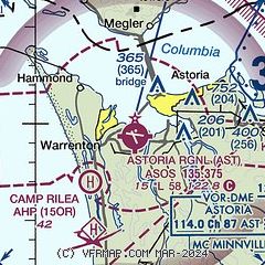
| Sectional chart |
|---|
|
| Airport distance calculator |
|---|
|
|
| Sunrise and sunset |
|---|
|
Times for 08-May-2026
| | Local
(UTC-7) | | Zulu
(UTC) |
|---|
| Morning civil twilight | | 05:18 | | 12:18 |
| Sunrise | | 05:53 | | 12:53 |
| Sunset | | 20:31 | | 03:31 |
| Evening civil twilight | | 21:06 | | 04:06 |
|
| Current date and time |
|---|
| Zulu (UTC) | 08-May-2026 14:02:23 |
|---|
| Local (UTC-7) | 08-May-2026 07:02:23 |
|---|
|
| METAR |
|---|
| KAST | 081355Z AUTO 17004KT 10SM OVC033 11/06 A3010 RMK AO2 SLP193 T01110056
|
|
| TAF |
|---|
| KAST | 081120Z 0812/0912 16003KT P6SM OVC025 FM081700 22006KT P6SM BKN020 FM081900 22009KT P6SM SCT023 FM090800 VRB03KT P6SM BKN030
|
|
| NOTAMs |
|---|
NOTAMs are issued by the DoD/FAA and will open in a separate window not controlled by AirNav.
|
|

