FAA INFORMATION EFFECTIVE 16 APRIL 2026
Location
| FAA Identifier: | B10 |
| Lat/Long: | 44-24-36.0000N 070-08-45.9000W
44-24.600000N 070-08.765000W
44.4100000,-70.1460833
(estimated) |
| Elevation: | 324.2 ft. / 98.8 m (surveyed) |
| Variation: | 18W (1985) |
| From city: | 4 miles SE of LIVERMORE FALLS, ME |
| Time zone: | UTC -4 (UTC -5 during Standard Time) |
| Zip code: | 04228 |
Airport Operations
| Airport use: | Open to the public |
| Activation date: | 12/1963 |
| Control tower: | no |
| ARTCC: | BOSTON CENTER |
| FSS: | BANGOR FLIGHT SERVICE STATION |
| NOTAMs facility: | BGR (NOTAM-D service available) |
| Attendance: | UNATNDD |
| Pattern altitude: | 1674.2 ft. MSL |
| Wind indicator: | yes |
| Segmented circle: | yes |
Airport Communications
| CTAF: | 122.9 |
| WX AWOS-AV at ME23 (13 nm N): | 122.8 (207-779-3105) |
| WX ASOS at AUG (16 nm E): | 118.325 (207-623-0432) |
Nearby radio navigation aids
| VOR radial/distance | | VOR name | | Freq | | Var |
|---|
| AUGr308/15.9 | | AUGUSTA VOR/DME | | 114.95 | | 18W |
| NDB name | | Hdg/Dist | | Freq | | Var | | ID |
|---|
| DUNNS | | 288/12.2 | | 366 | | 18W | | AU | .- ..- |
| BURNHAM | | 261/37.8 | | 348 | | 18W | | BUP | -... ..- .--. |
Airport Services
Runway Information
Runway 2/20
| Dimensions: | 2201 x 120 ft. / 671 x 37 m |
| Surface: | turf, in good condition |
| Runway edge markings: | END MARKED WITH YELLOW BARRELS AT THR, WHITE 2 FT BY 2 FT MKRS ALG SIDE. |
| RUNWAY 2 | | RUNWAY 20 |
| Latitude: | 44-24.421135N | | 44-24.779713N |
| Longitude: | 070-08.801473W | | 070-08.729217W |
| Elevation: | 316.5 ft. | | 324.2 ft. |
| Traffic pattern: | left | | left |
| Runway heading: | 026 magnetic, 008 true | | 206 magnetic, 188 true |
| Markings: | NSTD, in good condition | | NSTD, in good condition |
| Obstructions: | 65 ft. tree, 1 ft. from runway, 80 ft. left and right of centerline | | 60 ft. tree, 90 ft. from runway, 90 ft. left and right of centerline, 1:1 slope to clear |
Airport Ownership and Management from official FAA records
| Ownership: | Privately-owned |
| Owner: | BOWMAN FLYING CLUB INC
40 RIVER RD
LIVERMORE, ME 04228 |
| Manager: | KENNETH LYMAN
14 LYMAN LN
LIVERMORE FALLS, ME 04254
Phone 207-320-0587
ALTN NR 207-320-0589. |
Additional Remarks
| - | RWY NOT PLOWED IN WINTER; NO NGT OPS EXC IN EMERG. |
| - | RWY 02/20 800 FT BY 160 FT CLEAR AREA BYD THR TO RWY 2 SW. |
| - | RWY 2 40-70 FT TREES 800 FT FM THR, BOTH SIDES. |
| - | RWY 02/20 190 FT BY 200 FT CLEAR AREA BYD THR TO THE NE. |
| - | RWY 02/20 SOFT IN PLACES AFT RAIN, CALL AMGR FOR RWY CONDS. |
| - | ARPT LCTD NEAR 14 LYMAN LN, LIVERMORE FALLS, ME. |
| - | FOR CD CTC PORTLAND APCH AT 207-874-7320, WHEN APCH CLSD CTC BOSTON ARTCC AT 603-879-6859. |
Instrument Procedures
There are no published instrument procedures at B10.
Some nearby airports with instrument procedures:
KAUG - Augusta State Airport (16 nm E)
81B - Oxford County Regional Airport (21 nm SW)
KWVL - Waterville Regional Airport (21 nm E)
KOWK - Central Maine/Norridgewock Airport (22 nm NE)
KLEW - Auburn/Lewiston Municipal Airport (22 nm S)
|
|

Road maps at:
MapQuest
Bing
Google
| Aerial photo |
|---|
WARNING: Photo may not be current or correct

Do you have a better or more recent aerial photo of Bowman Field Airport that you would like to share? If so, please send us your photo.
|
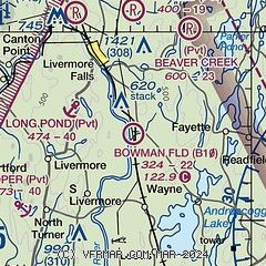
| Sectional chart |
|---|
|
| Airport distance calculator |
|---|
|
|
| Sunrise and sunset |
|---|
|
Times for 29-Apr-2026
| | Local
(UTC-4) | | Zulu
(UTC) |
|---|
| Morning civil twilight | | 05:03 | | 09:03 |
| Sunrise | | 05:35 | | 09:35 |
| Sunset | | 19:41 | | 23:41 |
| Evening civil twilight | | 20:12 | | 00:12 |
|
| Current date and time |
|---|
| Zulu (UTC) | 29-Apr-2026 10:17:49 |
|---|
| Local (UTC-4) | 29-Apr-2026 06:17:49 |
|---|
|
| METAR |
|---|
KAUG
16nm E | 290953Z AUTO 10SM OVC020 07/00 A3008 RMK AO2 SLP186 T00720000
|
KWVL
22nm E | 290956Z AUTO 00000KT 10SM OVC024 07/01 A3005 RMK AO2 SLP183 T00670011
|
KLEW
23nm S | 290956Z AUTO 00000KT 10SM OVC022 08/02 A3006 RMK AO2 SLP187 T00780017
|
|
| TAF |
|---|
KAUG
16nm E | 290521Z 2906/3006 00000KT P6SM OVC025 FM291000 VRB03KT P6SM OVC007 FM291400 11006KT 2SM BR OVC005 FM300000 12005KT 1 1/2SM BR OVC003
|
|
| NOTAMs |
|---|
NOTAMs are issued by the DoD/FAA and will open in a separate window not controlled by AirNav.
|
|

