FAA INFORMATION EFFECTIVE 09 JULY 2026
Location
| FAA Identifier: | WVL |
| Lat/Long: | 44-31-59.7000N 069-40-31.9000W
44-31.995000N 069-40.531667W
44.5332500,-69.6755278
(estimated) |
| Elevation: | 332.8 ft. / 101.4 m (surveyed) |
| Variation: | 18W (1995) |
| From city: | 2 miles SW of WATERVILLE, ME |
| Time zone: | UTC -4 (UTC -5 during Standard Time) |
| Zip code: | 04901 |
Airport Operations
| Airport use: | Open to the public |
| Activation date: | 04/1940 |
| Control tower: | no |
| ARTCC: | BOSTON CENTER |
| FSS: | BANGOR FLIGHT SERVICE STATION |
| NOTAMs facility: | WVL (NOTAM-D service available) |
| Attendance: | MAY-OCT 0900-1700, NOV-APR 0800-1600 |
| Wind indicator: | lighted |
| Segmented circle: | yes |
| Lights: | ACTVT MALSF RWY 05; REIL RWY 23; HIRL RWY 05/23 - CTAF. |
| Beacon: | white-green (lighted land airport)
Operates sunset to sunrise. |
Airport Communications
| CTAF/UNICOM: | 122.7 |
| WX AWOS-3PT: | 118.375 (207-877-0519) |
| PORTLAND APPROACH: | 128.35 [0545-0000] |
| PORTLAND DEPARTURE: | 128.35 [0545-0000] |
| CLEARANCE DELIVERY: | 124.6 |
| WX AWOS-AV at OWK (14 nm NW): | 123.075 |
| WX ASOS at AUG (14 nm S): | 118.325 (207-623-0432) |
- APCH/DEP SVC PRVDD BY BOSTON ARTCC ON FREQS 128.2/263.05 (112-292) (WATERBORO RCAG); FREQS 124.25/290.50 (293-111) (BANGOR RCAG) WHEN PORTLAND APCH CTL CLSD.
Nearby radio navigation aids
| VOR radial/distance | | VOR name | | Freq | | Var |
|---|
| AUGr040/13.8 | | AUGUSTA VOR/DME | | 114.95 | | 18W |
| BGRr261/38.9 | | BANGOR VORTAC | | 114.80 | | 19W |
| NDB name | | Hdg/Dist | | Freq | | Var | | ID |
|---|
| DUNNS | | 065/10.8 | | 366 | | 18W | | AU | .- ..- |
| BURNHAM | | 252/16.8 | | 348 | | 18W | | BUP | -... ..- .--. |
Airport Services
| Fuel available: | 100LL JET-A+
100LL:24 HR SELF SERVE.
A+:FOR FUEL AFT HRS EMAIL AIRPORT@WATERVILLE-ME.GOV. |
| Parking: | hangars and tiedowns |
| Airframe service: | NONE |
| Powerplant service: | NONE |
| Bottled oxygen: | NONE |
| Bulk oxygen: | NONE |
Runway Information
Runway 5/23
| Dimensions: | 5500 x 100 ft. / 1676 x 30 m |
| Surface: | asphalt/grooved, in excellent condition |
| Weight bearing capacity: | | Single wheel: | 40.0 | | Double wheel: | 60.0 | | Double tandem: | 105.0 |
|
| Runway edge lights: | high intensity |
| RUNWAY 5 | | RUNWAY 23 |
| Latitude: | 44-31.591133N | | 44-32.386000N |
| Longitude: | 069-40.838000W | | 069-40.232667W |
| Elevation: | 267.9 ft. | | 332.8 ft. |
| Traffic pattern: | left | | left |
| Runway heading: | 047 magnetic, 029 true | | 227 magnetic, 209 true |
| Markings: | precision, in good condition | | precision, in good condition |
| Visual slope indicator: | 4-box VASI on left (3.00 degrees glide path) | | 4-light PAPI on left (3.00 degrees glide path) |
| Approach lights: | MALSF: 1,400 foot medium intensity approach lighting system with sequenced flashers | | |
| Runway end identifier lights: | no | | yes |
| Touchdown point: | yes, no lights | | yes, no lights |
| Instrument approach: | ILS/DME | | |
Runway 14/32
| Dimensions: | 2301 x 60 ft. / 701 x 18 m |
| Surface: | asphalt, in excellent condition |
| Weight bearing capacity: | |
| RUNWAY 14 | | RUNWAY 32 |
| Latitude: | 44-32.120350N | | 44-31.901867N |
| Longitude: | 069-40.736650W | | 069-40.304333W |
| Elevation: | 307.6 ft. | | 298.6 ft. |
| Traffic pattern: | left | | left |
| Runway heading: | 143 magnetic, 125 true | | 323 magnetic, 305 true |
| Markings: | basic, in fair condition | | basic, in fair condition |
| Runway end identifier lights: | no | | no |
| Touchdown point: | yes, no lights | | yes, no lights |
| Obstructions: | 15 ft. trees, 402 ft. from runway, 50 ft. left of centerline, 13:1 slope to clear | | none |
Airport Ownership and Management from official FAA records
| Ownership: | Publicly-owned |
| Owner: | CITY OF WATERVILLE
1 COMMON ST
WATERVILLE, ME 04901
Phone 207-861-8013 |
| Manager: | RANDY MARSHALL JR
2 LAFLUER RD
WATERVILLE, ME 04901
Phone 207-861-8013
EMAIL: RMARSHALL@WATERVILLE-ME.GOV. |
Additional Remarks
| - | ACFT OPS ON PAVED AREA ONLY. |
| - | AVOID HOSPITAL 1 MI NORTH. |
| - | ACFT DE-ICING AVBL. |
| - | FOR CD WHEN APCH CLSD CTC BOSTON ARTCC AT 603-879-6859. |
Instrument Procedures
NOTE: All procedures below are presented as PDF files. If you need a reader for these files, you should download the free Adobe Reader.NOT FOR NAVIGATION. Please procure official charts for flight.
FAA instrument procedures published for use from 09 July 2026 at 0901Z to 06 August 2026 at 0900Z.
IAPs - Instrument Approach Procedures |
|---|
| ILS OR LOC/DME RWY 05 | |
download (342KB) |
| RNAV (GPS) RWY 05 | |
download (323KB) |
| RNAV (GPS) RWY 23 | |
download (247KB) |
| NOTE: Special Alternate Minimums apply | |
download (154KB) |
| NOTE: Special Take-Off Minimums/Departure Procedures apply | |
download (533KB) |
Other nearby airports with instrument procedures:
KOWK - Central Maine/Norridgewock Airport (14 nm NW)
KAUG - Augusta State Airport (14 nm S)
2B7 - Pittsfield Municipal Airport (19 nm NE)
KBST - Belfast Municipal Airport (29 nm E)
1B0 - Dexter Regional Airport (34 nm NE)
|
|

Road maps at:
MapQuest
Bing
Google
| Aerial photo |
|---|
WARNING: Photo may not be current or correct
 Photo by Kyle Warren Photography
Photo taken 20-Aug-2017
looking east.
Photo by Kyle Warren Photography
Photo taken 20-Aug-2017
looking east.
Do you have a better or more recent aerial photo of Waterville Regional Airport that you would like to share? If so, please send us your photo.
|
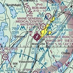
| Sectional chart |
|---|
|
CAUTION: Diagram may not be current

| Airport distance calculator |
|---|
|
|
| Sunrise and sunset |
|---|
|
Times for 13-Jul-2026
| | Local
(UTC-4) | | Zulu
(UTC) |
|---|
| Morning civil twilight | | 04:31 | | 08:31 |
| Sunrise | | 05:07 | | 09:07 |
| Sunset | | 20:22 | | 00:22 |
| Evening civil twilight | | 20:57 | | 00:57 |
|
| Current date and time |
|---|
| Zulu (UTC) | 13-Jul-2026 23:29:54 |
|---|
| Local (UTC-4) | 13-Jul-2026 19:29:54 |
|---|
|
| METAR |
|---|
| KWVL | 132256Z AUTO VRB05KT 10SM CLR 24/18 A2999 RMK AO2 SLP160 T02440178
|
KAUG
14nm S | 132253Z AUTO 17009G14KT 10SM CLR 24/18 A3001 RMK AO2 SLP163 T02390178
|
|
| TAF |
|---|
KAUG
14nm S | 131732Z 1318/1418 21011KT P6SM SCT070 SCT250 FM132300 20007KT P6SM VCSH FEW070 BKN100 BKN200 FM140400 24007KT P6SM SCT100 SCT150 SCT250
|
|
| NOTAMs |
|---|
NOTAMs are issued by the DoD/FAA and will open in a separate window not controlled by AirNav.
|
|


