FAA INFORMATION EFFECTIVE 19 FEBRUARY 2026
Location
| FAA Identifier: | BKL |
| Lat/Long: | 41-31-04.3000N 081-40-57.5000W
41-31.071667N 081-40.958333W
41.5178611,-81.6826389
(estimated) |
| Elevation: | 583.5 ft. / 177.9 m (surveyed) |
| Variation: | 07W (1990) |
| From city: | 1 mile N of CLEVELAND, OH |
| Time zone: | UTC -5 (UTC -4 during Daylight Saving Time) |
| Zip code: | 44114 |
Airport Operations
| Airport use: | Open to the public |
| Activation date: | 04/1948 |
| Control tower: | yes |
| ARTCC: | CLEVELAND CENTER |
| FSS: | CLEVELAND FLIGHT SERVICE STATION |
| NOTAMs facility: | BKL (NOTAM-D service available) |
| Attendance: | CONTINUOUS |
| Wind indicator: | lighted |
| Segmented circle: | yes |
| Lights: | WHEN ATCT CLSD ACTVT MALSF RWY 24R; REIL RWY 06L - CTAF. HIRL RWY 06L/24R PRESET MED INTST, TO INCR INTST RDO REQ ON UNICOM. PAPI RWY 06L & 24R OPR CONSLY. |
| Beacon: | white-green (lighted land airport)
Operates sunset to sunrise. |
| Landing fee: | yes, FEE SKED BASED ON NR OF ENGINES AND GWT. |
| Fire and rescue: | ARFF index A |
| Airline operations: | CLSD TO SKEDD ACR OPS GTR THAN 9 PAX SEATS. PPR FOR UNSKED ACR OPS WITH MORE THAN 30 PAX SEATS CALL AMGR. |
Airport Communications
| CTAF: | 124.3 |
| UNICOM: | 122.95 |
| ATIS: | 125.25 |
| WX ASOS: | PHONE 216-241-6904 |
| LAKEFRONT GROUND: | 121.9 339.8 [0700 MON TO 2300 FRI; 0700-2300 SAT; SUN 0800-0000] |
| LAKEFRONT TOWER: | 124.3 339.8 [0700 MON TO 2300 FRI; 0700-2300 SAT; SUN 0800-0000] |
| CLEVELAND APPROACH: | 125.35 |
| CLEVELAND DEPARTURE: | 125.35 |
| CLEARANCE DELIVERY: | 339.8 121.9 ;WHEN TWR CLSD |
| BRWNZ STAR: | 126.55 |
| ROKNN STAR: | 126.55 |
| ROLLN STAR: | 126.55 |
| TRYBE STAR: | 126.55 |
| WX AWOS-3PT at CGF (9 nm E): | PHONE 216-998-7640 |
| WX ASOS at CLE (10 nm SW): | PHONE 216-264-9022 |
| WX AWOS-3PT at LNN (16 nm NE): | 119.225 (440-942-0809) |
Nearby radio navigation aids
| VOR radial/distance | | VOR name | | Freq | | Var |
|---|
| CXRr275/23.3 | | CHARDON VOR/DME | | 112.70 | | 05W |
| DJBr071/23.6 | | DRYER VOR/DME | | 113.60 | | 05W |
| ACOr323/32.8 | | AKRON VOR/DME | | 114.40 | | 04W |
Airport Services
| Fuel available: | 100LL JET-A |
| Parking: | hangars and tiedowns |
| Airframe service: | MAJOR |
| Powerplant service: | MAJOR |
| Bottled oxygen: | NONE |
| Bulk oxygen: | HIGH/LOW |
Runway Information
Runway 6L/24R
| Dimensions: | 6604 x 150 ft. / 2013 x 46 m |
| Surface: | asphalt/grooved, in good condition |
| Weight bearing capacity: | | Single wheel: | 93.0 | | Double wheel: | 113.0 | | Double tandem: | 170.0 |
|
| Runway edge lights: | high intensity |
| RUNWAY 6L | | RUNWAY 24R |
| Latitude: | 41-30.847978N | | 41-31.425645N |
| Longitude: | 081-41.523330W | | 081-40.297590W |
| Elevation: | 581.1 ft. | | 582.4 ft. |
| Traffic pattern: | left | | right |
| Runway heading: | 065 magnetic, 058 true | | 245 magnetic, 238 true |
| Displaced threshold: | 178 ft. | | 600 ft. |
| Declared distances: | TORA:6503 TODA:6503 ASDA:6503 LDA:6325 | | TORA:6603 TODA:6603 ASDA:6603 LDA:6003 |
| Markings: | precision, in good condition | | precision, in good condition |
| Visual slope indicator: | 4-light PAPI on right (3.00 degrees glide path)
UNUSBL BYD 5 DEGS RIGHT OF CNTRLN. | | 4-light PAPI on right (3.00 degrees glide path)
UNUSBL BYD 8 DEGS LEFT OF CRS. |
| Approach lights: | | | MALSF: 1,400 foot medium intensity approach lighting system with sequenced flashers |
| Runway end identifier lights: | yes | | |
| Touchdown point: | yes, no lights | | yes, no lights |
| Instrument approach: | | | ILS/DME |
| Obstructions: | none
RWY 06L/24R & RWY 06R/24L APCH SFCS HAVE NAVIGABLE WATERWAYS CREATING POSSIBLE VESSEL OBSTRUCTION AREAS - CHECK LOCAL NOTAMS FOR CURRENT ACTIVITY; VESSEL HEIGHT; ETC. | | 122 ft. bldg, 3364 ft. from runway, 837 ft. left of centerline, 25:1 slope to clear |
Runway 6R/24L
| Dimensions: | 5197 x 100 ft. / 1584 x 30 m |
| Surface: | asphalt/grooved, in good condition |
| Weight bearing capacity: | | PCN 63 /F/C/X/T | | Single wheel: | 43.0 | | Double wheel: | 50.0 | | Double tandem: | 82.0 |
|
| Runway edge lights: | high intensity |
| Operational restrictions: | RWY 06R/24L NOT AVBL FOR PART 121/PART 380 OPS WITH SKED PAX CARRYING OPS MORE THAN 9 PAX SEATS AND NON-SKED PAX CARRYING OPS MORE THAN 30 PAX SEATS. CLSD WHEN ATCT CLSD. |
| RUNWAY 6R | | RUNWAY 24L |
| Latitude: | 41-30.761305N | | 41-31.215758N |
| Longitude: | 081-41.501292W | | 081-40.536583W |
| Elevation: | 580.5 ft. | | 582.5 ft. |
| Traffic pattern: | left | | right |
| Runway heading: | 065 magnetic, 058 true | | 245 magnetic, 238 true |
| Displaced threshold: | 275 ft. | | no |
| Declared distances: | TORA:5199 TODA:5199 ASDA:5199 LDA:4924 | | TORA:5199 TODA:5199 ASDA:5199 LDA:5199 |
| Markings: | basic, in good condition | | basic, in good condition |
| Runway end identifier lights: | | | yes |
| Touchdown point: | yes, no lights | | yes, no lights |
| Obstructions: | none | | 274 ft. ant, lighted, 6560 ft. from runway, 1222 ft. left of centerline, 23:1 slope to clear |
Airport Ownership and Management from official FAA records
| Ownership: | Publicly-owned |
| Owner: | CITY OF CLEVELAND
1501 N MARGINAL RD
CLEVELAND, OH 44114
Phone 216-781-6411 |
| Manager: | JOEL WOODS
1501 N MARGINAL RD
CLEVELAND, OH 44114
Phone 216-781-6411 |
Additional Remarks
| A39-06L/24R | PCR VALUE: 426/F/C/X/T |
| - | BIRDS AND WATERFOWL ON & INVOF ARPT. |
| - | FLIGHT NOTIFICATION SERVICE (ADCUS) AVBL 24 HRS MON-FRI REQ FOR SERVICE ON SAT; SUN & HOLS MUST BE MADE PRIOR TO 1630 ON FRI; 2 HRS ADVANCE NOTICE REQUIRED CALL 216-267-3600. PRIVATE ACFT & GENERAL AVIATION ONLY. |
| - | 72 FT SHIP CRANE 1300 FT SW OF RWY 06R. |
| - | FOR CD WHEN ATCT CLSD CTC CLEVELAND APCH AT 216-352-2323. |
Instrument Procedures
NOTE: All procedures below are presented as PDF files. If you need a reader for these files, you should download the free Adobe Reader.NOT FOR NAVIGATION. Please procure official charts for flight.
FAA instrument procedures published for use from 19 February 2026 at 0901Z to 19 March 2026 at 0900Z.
STARs - Standard Terminal Arrivals |
|---|
| BRWNZ FOUR (RNAV) | |
2 pages:
[1] [2] (448KB) |
| BRWNZ FOUR (RNAV), CONT.2 | |
download (235KB) |
| ROKNN FOUR (RNAV) | |
2 pages:
[1] [2] (449KB) |
| ROLLN TWO (RNAV) | |
download (344KB) |
| TRYBE FOUR (RNAV) | |
2 pages:
[1] [2] (381KB) |
IAPs - Instrument Approach Procedures |
|---|
| ILS OR LOC RWY 24R | |
download (247KB) |
| RNAV (GPS) RWY 24R | |
download (225KB) |
| NOTE: Special Alternate Minimums apply | |
download (167KB) |
Departure Procedures |
|---|
| AHMET FIVE (RNAV) | |
download (218KB) |
| CAVVS FIVE (RNAV) | |
download (218KB) |
| GTLKE FIVE (RNAV) | |
2 pages:
[1] [2] (333KB) |
| MYCAR FIVE (RNAV) | |
download (215KB) |
| ZAAPA SIX (RNAV) | |
download (246KB) |
| NOTE: Special Take-Off Minimums/Departure Procedures apply | |
download (471KB) |
Other nearby airports with instrument procedures:
KCGF - Cuyahoga County Airport (9 nm E)
KCLE - Cleveland-Hopkins International Airport (10 nm SW)
KLNN - Lake County Executive Airport (16 nm NE)
1G1 - Elyria Airport (22 nm SW)
1G5 - Medina Municipal Airport (23 nm S)
|
|

Road maps at:
MapQuest
Bing
Google
| Aerial photo |
|---|
WARNING: Photo may not be current or correct
 Photo taken 26-Feb-2018
looking north.
Photo taken 26-Feb-2018
looking north.
Do you have a better or more recent aerial photo of Burke Lakefront Airport that you would like to share? If so, please send us your photo.
|
| Sectional chart |
|---|
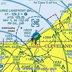
|
 Download PDF
of official airport diagram from the FAA
| Airport distance calculator |
|---|
|
|
| Sunrise and sunset |
|---|
|
Times for 11-Mar-2026
| | Local
(UTC-4) | | Zulu
(UTC) |
|---|
| Morning civil twilight | | 07:19 | | 11:19 |
| Sunrise | | 07:46 | | 11:46 |
| Sunset | | 19:27 | | 23:27 |
| Evening civil twilight | | 19:55 | | 23:55 |
|
| Current date and time |
|---|
| Zulu (UTC) | 12-Mar-2026 01:13:51 |
|---|
| Local (UTC-4) | 11-Mar-2026 21:13:51 |
|---|
|
| METAR |
|---|
| KBKL | 120053Z 27021KT 9SM SCT012 OVC019 04/04 A2976 RMK AO2 PK WND 27029/0050 RAE44 PRESRR SLP081 P0004 T00440039 $
|
KCLE
10nm SW | 120103Z 29016G29KT 10SM SCT011 OVC018 06/03 A2975 RMK AO2 PK WND 29029/0052 T00560033 $
|
KCGF
10nm E | 120045Z 29013G18KT 2SM -RA BR OVC002 05/05 A2975
|
KLNN
17nm NE | 120055Z AUTO 27010G14KT 5SM OVC004 04/03 A2977 RMK AO1 T00370025
|
|
| TAF |
|---|
KCLE
10nm SW | 112057Z 1121/1224 26015G27KT 6SM -SHRA SCT015 OVC025 FM120000 30015G25KT P6SM SCT008 OVC015 FM121200 30012KT P6SM BKN050 FM121600 30012KT P6SM SCT050
|
|
| NOTAMs |
|---|
NOTAMs are issued by the DoD/FAA and will open in a separate window not controlled by AirNav.
|
|


