FAA INFORMATION EFFECTIVE 14 MAY 2026
Location
| FAA Identifier: | BOW |
| Lat/Long: | 27-56-36.0910N 081-47-00.3740W
27-56.601517N 081-47.006233W
27.9433586,-81.7834372
(estimated) |
| Elevation: | 124.6 ft. / 38.0 m (surveyed) |
| Variation: | 04W (1995) |
| From city: | 4 miles NE of BARTOW, FL |
| Time zone: | UTC -4 (UTC -5 during Standard Time) |
| Zip code: | 33830 |
Airport Operations
| Airport use: | Open to the public |
| Activation date: | 02/1944 |
| Control tower: | yes |
| ARTCC: | MIAMI CENTER |
| FSS: | SAINT PETERSBURG FLIGHT SERVICE STATION |
| NOTAMs facility: | BOW (NOTAM-D service available) |
| Attendance: | 0600-1800
UNATTND EASTER, INDEPENDANCE DAY, THANKSGIVING & CHRISTMAS. |
| Wind indicator: | lighted |
| Segmented circle: | yes |
| Lights: | ACTVT REILS RWY 05, 09L, 23 & 27R; PAPI RWYS 05, 09L, 23, & 27R; MIRL RWYS 05/23 & 09L/27R; AND WIND CONE - CTAF. REIL RWYS 05, 09L, 23 & 27R OPER WHEN MIRL RWYS 05/23 & 09L/27R HIGH INTST ONLY. |
| Beacon: | white-green (lighted land airport)
Operates sunset to sunrise. |
Airport Communications
| CTAF: | 121.2 |
| UNICOM: | 122.95 |
| WX AWOS-3: | 123.775 (863-533-9004) |
| BARTOW GROUND: | 121.9 [0730-1730] |
| BARTOW TOWER: | 121.2 121.5R [0730-1730] |
| TAMPA APPROACH: | 120.65 119.9 |
| TAMPA DEPARTURE: | 120.65 119.9 |
| EMERG: | 121.5 |
| WX ASOS at GIF (7 nm N): | 133.675 (863-956-2097) |
| WX AWOS-3 at X07 (9 nm E): | 124.225 (863-678-1334) |
| WX AWOS-3PT at LAL (13 nm W): | PHONE 863-834-2030 |
- ATCT CLSD EASTER; THANKSGIVING; CHRISTMAS; & OTHER HOLS BY NOTAM.
Nearby radio navigation aids
| VOR radial/distance | | VOR name | | Freq | | Var |
|---|
| LALr101/12.5 | | LAKELAND VORTAC | | 116.00 | | 01E |
Airport Services
| Fuel available: | 100LL JET-A
100LL:100LL AVBL 24 HRS WITH CREDIT CARD. |
| Parking: | tiedowns |
| Airframe service: | MAJOR |
| Powerplant service: | MAJOR |
| Bottled oxygen: | NONE |
| Bulk oxygen: | NONE |
Runway Information
Runway 5/23
| Dimensions: | 5001 x 100 ft. / 1524 x 30 m |
| Surface: | asphalt, in poor condition
CRACKING THRUT RWY 05/23. |
| Weight bearing capacity: | | PCN 27 /F/A/X/T | | Single wheel: | 35.0 | | Double wheel: | 60.0 | | Double tandem: | 110.0 |
|
| Runway edge lights: | medium intensity |
| RUNWAY 5 | | RUNWAY 23 |
| Latitude: | 27-56.288747N | | 27-56.861127N |
| Longitude: | 081-47.363900W | | 081-46.694528W |
| Elevation: | 107.9 ft. | | 122.2 ft. |
| Traffic pattern: | left | | left |
| Runway heading: | 050 magnetic, 046 true | | 230 magnetic, 226 true |
| Markings: | nonprecision, in fair condition | | nonprecision, in fair condition |
| Visual slope indicator: | 4-light PAPI on left (3.50 degrees glide path) | | 4-light PAPI on left (3.50 degrees glide path) |
| Runway end identifier lights: | yes | | yes |
| Touchdown point: | yes, no lights | | yes, no lights |
| Obstructions: | 36 ft. trees, 1335 ft. from runway, 205 ft. left of centerline, 31:1 slope to clear | | 23 ft. trees, 770 ft. from runway, 200 ft. left of centerline, 24:1 slope to clear |
Runway 9L/27R
| Dimensions: | 5000 x 150 ft. / 1524 x 46 m |
| Surface: | asphalt, in fair condition |
| Weight bearing capacity: | |
| Runway edge lights: | medium intensity |
| RUNWAY 9L | | RUNWAY 27R |
| Latitude: | 27-56.673068N | | 27-56.715102N |
| Longitude: | 081-47.436642W | | 081-46.508657W |
| Elevation: | 116.9 ft. | | 114.5 ft. |
| Traffic pattern: | left | | right |
| Runway heading: | 091 magnetic, 087 true | | 271 magnetic, 267 true |
| Markings: | nonprecision, in fair condition | | nonprecision, in fair condition |
| Visual slope indicator: | 4-light PAPI on left (3.00 degrees glide path) | | 4-light PAPI on left (3.00 degrees glide path) |
| Runway end identifier lights: | yes | | yes |
| Touchdown point: | yes, no lights | | yes, no lights |
| Obstructions: | 62 ft. tree, 2290 ft. from runway, 110 ft. right of centerline, 34:1 slope to clear | | 28 ft. tree, 1130 ft. from runway, 240 ft. left of centerline, 34:1 slope to clear |
Runway 9R/27L
| Dimensions: | 4416 x 150 ft. / 1346 x 46 m |
| Surface: | asphalt/concrete, in poor condition
RWY 09R/27L PRODUCING LOOSE AGGREGATE IN SOME AREAS.
RWY 27L CONC 1ST 300 FT. |
| Weight bearing capacity: | |
| RUNWAY 9R | | RUNWAY 27L |
| Latitude: | 27-56.508177N | | 27-56.545423N |
| Longitude: | 081-47.428055W | | 081-46.608430W |
| Elevation: | 112.3 ft. | | 111.6 ft. |
| Traffic pattern: | right | | left |
| Runway heading: | 091 magnetic, 087 true | | 271 magnetic, 267 true |
| Markings: | basic, in fair condition | | basic, in fair condition |
| Touchdown point: | yes, no lights | | yes, no lights |
| Obstructions: | 56 ft. trees, 1900 ft. from runway, 175 ft. left of centerline, 31:1 slope to clear | | 40 ft. trees, 1000 ft. from runway, 30 ft. right of centerline, 20:1 slope to clear |
Airport Ownership and Management from official FAA records
| Ownership: | Publicly-owned |
| Owner: | BARTOW MUNI ARPT DVLPMNT AUTH
PO BOX 650
BARTOW, FL 33831-0650
Phone 863-533-1195 |
| Manager: | JOHN B. HELMS, II
5993 AIRPORT BLVD
BARTOW, FL 33830
Phone 863-533-1195 |
Additional Remarks
| - | OVERHEAD PLINES IN T-HANGAR AREA - APPROX 20' VERTICAL CLEARANCE. |
| - | WILDLIFE INVOF ARPT. |
| - | WHEN ATCT CLSD, FOR CD CTC TAMPA APCH AT 813-878-2528 |
Instrument Procedures
NOTE: All procedures below are presented as PDF files. If you need a reader for these files, you should download the free Adobe Reader.NOT FOR NAVIGATION. Please procure official charts for flight.
FAA instrument procedures published for use from 14 May 2026 at 0901Z to 11 June 2026 at 0900Z.
IAPs - Instrument Approach Procedures |
|---|
| RNAV (GPS) RWY 05 | |
download (266KB) |
| RNAV (GPS) RWY 09L | |
download (221KB) |
| RNAV (GPS) RWY 23 | |
download (272KB) |
| RNAV (GPS) RWY 27R | |
download (231KB) |
| VOR RWY 09L | |
download (211KB) |
| NOTE: Special Alternate Minimums apply | |
download (126KB) |
| NOTE: Special Take-Off Minimums/Departure Procedures apply | |
download (408KB) |
Other nearby airports with instrument procedures:
KGIF - Winter Haven Regional Airport (7 nm N)
X07 - Lake Wales Municipal Airport (9 nm E)
KLAL - Lakeland Linder International Airport (13 nm W)
KPCM - Plant City Airport (20 nm W)
KAVO - Avon Park Executive Airport (25 nm SE)
|
|

Road maps at:
MapQuest
Bing
Google
| Aerial photo |
|---|
WARNING: Photo may not be current or correct
 Photo by Gregory White
Photo taken 01-Apr-2008
Photo by Gregory White
Photo taken 01-Apr-2008
Do you have a better or more recent aerial photo of Bartow Executive Airport that you would like to share? If so, please send us your photo.
|
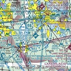
| Sectional chart |
|---|
|
CAUTION: Diagram may not be current

| Airport distance calculator |
|---|
|
|
| Sunrise and sunset |
|---|
|
Times for 30-May-2026
| | Local
(UTC-4) | | Zulu
(UTC) |
|---|
| Morning civil twilight | | 06:06 | | 10:06 |
| Sunrise | | 06:32 | | 10:32 |
| Sunset | | 20:17 | | 00:17 |
| Evening civil twilight | | 20:43 | | 00:43 |
|
| Current date and time |
|---|
| Zulu (UTC) | 30-May-2026 20:40:17 |
|---|
| Local (UTC-4) | 30-May-2026 16:40:17 |
|---|
|
| METAR |
|---|
| KBOW | 302015Z AUTO 17006G12KT 10SM BKN043 BKN050 BKN055 31/22 A2994 RMK AO2 LTG DSNT N PWINO
|
KGIF
8nm N | 301953Z AUTO 21010KT 10SM BKN047 32/21 A2994 RMK AO1 SLP137 T03220206
|
KLAL
12nm W | 301950Z 24005KT 10SM SCT043 33/23 A2994
|
|
| TAF |
|---|
KLAL
12nm W | 301720Z 3018/3118 28007KT P6SM VCSH SCT040 BKN150 PROB30 3019/3023 5SM -TSRA BKN030CB FM310000 VRB03KT P6SM BKN150 FM311600 27006KT P6SM VCSH SCT025 BKN150
|
|
| NOTAMs |
|---|
NOTAMs are issued by the DoD/FAA and will open in a separate window not controlled by AirNav.
|
|


