FAA INFORMATION EFFECTIVE 14 MAY 2026
Location
| FAA Identifier: | DEC |
| Lat/Long: | 39-50-04.4250N 088-51-56.4810W
39-50.073750N 088-51.941350W
39.8345625,-88.8656892
(estimated) |
| Elevation: | 681.9 ft. / 207.8 m (surveyed) |
| Variation: | 01W (2000) |
| From city: | 4 miles E of DECATUR, IL |
| Time zone: | UTC -5 (UTC -6 during Standard Time) |
| Zip code: | 62521 |
Airport Operations
| Airport use: | Open to the public |
| Activation date: | 03/1945 |
| Control tower: | yes |
| ARTCC: | CHICAGO CENTER |
| FSS: | SAINT LOUIS FLIGHT SERVICE STATION |
| NOTAMs facility: | DEC (NOTAM-D service available) |
| Attendance: | MON-FRI 24 HOURS/DAY, ALL SAT SUN 0700-2130 |
| Wind indicator: | lighted |
| Segmented circle: | no |
| Lights: | ACTVT MALSR RWY 06; MIRL RWY 12/30 & 18/36; TWY LGTS RWY 06 - CTAF. WHEN ATCT CLSD HIRL RWY 06/24 PRESET LOW INTST; INCR INTST - CTAF. |
| Beacon: | white-green (lighted land airport)
Operates sunset to sunrise. |
| Fire and rescue: | ARFF index A |
| Airline operations: | INDEX B ARFF CAPABILITY RQR 24 HR PPR - CTC AMGR. |
Airport Communications
| CTAF: | 118.9 |
| UNICOM: | 122.95 |
| ATIS: | 126.35 |
| WX ASOS: | PHONE 217-429-0052 |
| DECATUR GROUND: | 121.75 291.775 [0600-2200] |
| DECATUR TOWER: | 118.9 291.775 [0600-2200] |
| CHAMPAIGN APPROACH: | 132.85 |
| CHAMPAIGN DEPARTURE: | 132.85 |
- APCH/DEP SVC PRVDD BY CHICAGO ARTCC ON FREQ 121.35 (REMOTED CHAMPAIGN APCH CTL) AND FREQ 353.95 (DANVILLE RCAG) WHEN CHAMPAIGN APCH CTL CLSD.
Nearby radio navigation aids
| VOR radial/distance | | VOR name | | Freq | | Var |
|---|
| AXCr353/5.8 | | ADDERS VORTAC | | 117.20 | | 03E |
| CMIr243/29.7 | | CHAMPAIGN VORTAC | | 115.75 | | 03E |
| SPIr091/37.4 | | SPINNER VORTAC | | 112.70 | | 01W |
| NDB name | | Hdg/Dist | | Freq | | Var | | ID |
|---|
| ELWIN | | 058/4.9 | | 275 | | 01W | | DE | -.. . |
| SHELBYVILLE | | 360/25.7 | | 365 | | 02W | | SYZ | ... -.-- --.. |
| ABRAHAM | | 132/29.2 | | 329 | | 00E | | AAA | .- .- .- |
Airport Services
| Fuel available: | 100LL JET-A |
| Parking: | hangars and tiedowns |
Runway Information
Runway 6/24
| Dimensions: | 8496 x 150 ft. / 2590 x 46 m |
| Surface: | asphalt/concrete/grooved, in good condition |
| Weight bearing capacity: | | Single wheel: | 120.0 | | Double wheel: | 250.0 | | Double tandem: | 550.0 | | Dual double tandem: | 1120.0 |
|
| Runway edge lights: | high intensity |
| RUNWAY 6 | | RUNWAY 24 |
| Latitude: | 39-49.625887N | | 39-50.343747N |
| Longitude: | 088-52.471000W | | 088-50.913110W |
| Elevation: | 672.7 ft. | | 681.8 ft. |
| Traffic pattern: | left | | left |
| Runway heading: | 060 magnetic, 059 true | | 240 magnetic, 239 true |
| Declared distances: | TORA:8496 TODA:8496 ASDA:8496 LDA:8496 | | TORA:8496 TODA:8496 ASDA:8496 LDA:8496 |
| Markings: | precision, in good condition | | precision, in fair condition |
| Visual slope indicator: | | | 4-box VASI on left (3.00 degrees glide path) |
| RVR equipment: | touchdown, midfield | | midfield, rollout |
| Approach lights: | MALSR: 1,400 foot medium intensity approach lighting system with runway alignment indicator lights | | |
| Runway end identifier lights: | no | | no |
| Touchdown point: | yes, no lights | | yes, no lights |
| Instrument approach: | ILS/DME | | |
| Obstructions: | 17 ft. road, 885 ft. from runway, 599 ft. left of centerline, 39:1 slope to clear | | none |
Runway 12/30
| Dimensions: | 6799 x 150 ft. / 2072 x 46 m |
| Surface: | asphalt/concrete/grooved, in good condition |
| Weight bearing capacity: | | Single wheel: | 120.0 | | Double wheel: | 250.0 | | Double tandem: | 550.0 | | Dual double tandem: | 1120.0 |
|
| Runway edge lights: | medium intensity |
| RUNWAY 12 | | RUNWAY 30 |
| Latitude: | 39-50.475063N | | 39-49.929888N |
| Longitude: | 088-52.488035W | | 088-51.219165W |
| Elevation: | 678.3 ft. | | 678.0 ft. |
| Traffic pattern: | left | | left |
| Runway heading: | 120 magnetic, 119 true | | 300 magnetic, 299 true |
| Declared distances: | TORA:6799 TODA:6799 ASDA:6799 LDA:6799 | | TORA:6799 TODA:6799 ASDA:6799 LDA:6799 |
| Markings: | nonprecision, in good condition | | nonprecision, in fair condition |
| Visual slope indicator: | | | 4-light PAPI on left (3.00 degrees glide path) |
| Runway end identifier lights: | no | | |
| Touchdown point: | yes, no lights | | yes, no lights |
| Obstructions: | 43 ft. tree, 1174 ft. from runway, 288 ft. right of centerline, 22:1 slope to clear | | none |
Runway 18/36
| Dimensions: | 5298 x 150 ft. / 1615 x 46 m |
| Surface: | asphalt/grooved, in good condition |
| Weight bearing capacity: | | Single wheel: | 120.0 | | Double wheel: | 250.0 | | Double tandem: | 550.0 | | Dual double tandem: | 1035.0 |
|
| Runway edge lights: | medium intensity |
| RUNWAY 18 | | RUNWAY 36 |
| Latitude: | 39-50.487062N | | 39-49.614535N |
| Longitude: | 088-52.462377W | | 088-52.445007W |
| Elevation: | 678.9 ft. | | 672.2 ft. |
| Traffic pattern: | left | | left |
| Runway heading: | 180 magnetic, 179 true | | 000 magnetic, 359 true |
| Declared distances: | TORA:5298 TODA:5298 ASDA:5298 LDA:5298 | | TORA:5298 TODA:5298 ASDA:5298 LDA:5298 |
| Markings: | nonprecision, in good condition | | nonprecision, in good condition |
| Visual slope indicator: | 4-light PAPI on left (3.00 degrees glide path) | | 4-box VASI on left (3.00 degrees glide path) |
| Runway end identifier lights: | | | no |
| Touchdown point: | yes, no lights | | yes, no lights |
| Obstructions: | 55 ft. trees, 1755 ft. from runway, 15 ft. right of centerline, 28:1 slope to clear | | 50 ft. pole, 2344 ft. from runway, 461 ft. left of centerline, 42:1 slope to clear |
Airport Ownership and Management from official FAA records
| Ownership: | Publicly-owned |
| Owner: | DECATUR PARK DISTRICT
620 E. RIVERSIDE AVE.
DECATUR, IL 62521
Phone 217-428-2423 |
| Manager: | TIM A. WRIGHT
910 S. AIRPORT ROAD
DECATUR, IL 62521
Phone 217-428-2423 |
Additional Remarks
| A39-18/36 | PCR VALUE: 1200/F/D/X/T |
| A39-12/30 | PCR VALUE: 3250/F/D/X/T |
| A39-06/24 | PCR VALUE: 3280/F/D/X/T |
| - | N RAMP FROM HNGR B TO HNGR G CLSD TO ACFT OVR 12500 LBS. |
| - | WHEN ATCT CLSD BE ALERT FOR VEHICULAR TFC IN ARPT OPS AREAS. |
| - | BIRDS & WILDLIFE ON & INVOF ARPT. |
| - | GLIDER OPS RWY 06 & 30 ONLY, RQR WRITTEN APVL - CTC AMGR. SOD OPS NA. |
| - | SNOW REMOVAL OPS WINTER MONTHS MNT CTAF. LNDG/DEP ACFT USE CTAF WHEN ATCT CLSD. |
| - | FOR US CUSTOMS CALL 217-425-4803. |
| - | RWY 12 & 18 AND RWY 06 & 36 CLOSELY ALIGNED. VFY CORRECT RWY AND COMPASS HDG PRIOR TO DEP. |
| - | TWY A RSTRD NORTH OF TWY G TO ACFT WITH WINGSPAN OF 86FT OR LESS WITHOUT PPR - CTC AMGR. |
| - | FOR CD IF UNA TO CTC ON FSS FREQ, CTC CHICAGO ARTCC 630-906-8921. |
| - | (LAHSO_ALD, RWY 24) SECONDARY LAHSO 8000 FT HOLD SHORT OF RWY 18/36. |
| - | (CONTACT TITLE) 217-428-8836 |
Instrument Procedures
NOTE: All procedures below are presented as PDF files. If you need a reader for these files, you should download the free Adobe Reader.NOT FOR NAVIGATION. Please procure official charts for flight.
FAA instrument procedures published for use from 14 May 2026 at 0901Z to 11 June 2026 at 0900Z.
IAPs - Instrument Approach Procedures |
|---|
| ILS OR LOC RWY 06 | |
download (330KB) |
| RNAV (GPS) RWY 06 | |
download (271KB) |
| RNAV (GPS) RWY 12 | |
download (255KB) |
| RNAV (GPS) RWY 18 | |
download (238KB) |
| RNAV (GPS) RWY 24 | |
download (286KB) |
| RNAV (GPS) RWY 30 | |
download (266KB) |
| RNAV (GPS) RWY 36 | |
download (263KB) |
| LOC BC RWY 24 | |
download (266KB) |
| VOR RWY 18 | |
download (235KB) |
| VOR RWY 36 | |
download (244KB) |
| NOTE: Special Alternate Minimums apply | |
download (138KB) |
| NOTE: Special Take-Off Minimums/Departure Procedures apply | |
download (201KB) |
Other nearby airports with instrument procedures:
2H0 - Shelby County Airport (25 nm S)
KTAZ - Taylorville Municipal Airport (28 nm SW)
KAAA - Logan County Airport (29 nm NW)
KCMI - University of Illinois/Willard Airport (30 nm NE)
KMTO - Coles County Memorial Airport (34 nm SE)
|
|

Road maps at:
MapQuest
Bing
Google
| Aerial photo |
|---|
WARNING: Photo may not be current or correct
 Photo by W.E.McCowan
Taken in May 2017
looking southeast.
Photo by W.E.McCowan
Taken in May 2017
looking southeast.
Do you have a better or more recent aerial photo of Decatur Airport that you would like to share? If so, please send us your photo.
|
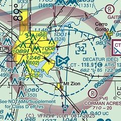
| Sectional chart |
|---|
|
 Download PDF
of official airport diagram from the FAA
| Airport distance calculator |
|---|
|
|
| Sunrise and sunset |
|---|
|
Times for 05-Jun-2026
| | Local
(UTC-5) | | Zulu
(UTC) |
|---|
| Morning civil twilight | | 04:56 | | 09:56 |
| Sunrise | | 05:29 | | 10:29 |
| Sunset | | 20:19 | | 01:19 |
| Evening civil twilight | | 20:51 | | 01:51 |
|
| Current date and time |
|---|
| Zulu (UTC) | 06-Jun-2026 01:31:00 |
|---|
| Local (UTC-5) | 05-Jun-2026 20:31:00 |
|---|
|
| METAR |
|---|
| KDEC | 060054Z 21013KT 10SM BKN050 OVC070 27/19 A2990 RMK AO2 SLP118 T02720189
|
|
| TAF |
|---|
| KDEC | 051732Z 0518/0618 21016G26KT P6SM SCT050 FM060000 21010KT P6SM SCT100 FM061300 23011KT P6SM BKN060
|
|
| NOTAMs |
|---|
NOTAMs are issued by the DoD/FAA and will open in a separate window not controlled by AirNav.
|
|


