FAA INFORMATION EFFECTIVE 16 APRIL 2026
Location
| FAA Identifier: | CHA |
| Lat/Long: | 35-02-06.7000N 085-12-12.8000W
35-02.111667N 085-12.213333W
35.0351944,-85.2035556
(estimated) |
| Elevation: | 682.5 ft. / 208.0 m (surveyed) |
| Variation: | 05W (2020) |
| From city: | 5 miles E of CHATTANOOGA, TN |
| Time zone: | UTC -4 (UTC -5 during Standard Time) |
| Zip code: | 37421 |
Airport Operations
| Airport use: | Open to the public |
| Activation date: | 11/1937 |
| Control tower: | yes |
| ARTCC: | ATLANTA CENTER |
| FSS: | NASHVILLE FLIGHT SERVICE STATION |
| NOTAMs facility: | CHA (NOTAM-D service available) |
| Attendance: | CONTINUOUS |
| Wind indicator: | lighted |
| Segmented circle: | yes |
| Lights: | ACTVT MALSR RWY 02; TDZL RWY 20; CNTRLN LGTS RWY 02/20; HIRL RWY 02/20 - CTAF. MIRL RWY 15/33 UNAVBL WHEN ATCT CLSD. |
| Beacon: | white-green (lighted land airport)
Operates sunset to sunrise. |
| Fire and rescue: | ARFF index B |
| Airline operations: | ARFF INDEX C AVBL O/R. |
| International operations: | customs landing rights airport |
Airport Communications
| CTAF: | 118.3 |
| UNICOM: | 122.95 |
| ATIS: | 119.85 |
| WX ASOS: | 119.85 (423-668-0530) |
| CHATTANOOGA GROUND: | 121.7 348.6 [0600-2350] |
| CHATTANOOGA TOWER: | 118.3 257.8 [0600-2350] |
| CHATTANOOGA APPROACH: | 125.1 379.1 [0600-2350] |
| ATLANTA ARTCC APPROACH: | 126.5 [2350-0600] |
| CHATTANOOGA DEPARTURE: | 125.1 379.1 [0600-2350] |
| CLEARANCE DELIVERY: | 120.95 348.6 |
| CLASS C: | 125.1 379.1 |
| EMERG: | 121.5 243.0 |
| NG OPS: | 149.8 373.9 41.5FM |
| WX AWOS-2 at FGU (9 nm E): | 118.675 (423-236-4028) |
- APCH/DEP SVC PRVDD BY ATLANTA ARTCC ON FREQS 132.05/354.025 (CHATTANOOGA RCAG) WHEN CHATTANOOGA APCH CTL CLSD.
Nearby radio navigation aids
| NDB name | | Hdg/Dist | | Freq | | Var | | ID |
|---|
| DAISY | | 198/8.2 | | 341 | | 02W | | CQN | -.-. --.- -. |
Airport Services
| Fuel available: | 100LL JET-A |
| Parking: | hangars and tiedowns |
| Airframe service: | MAJOR |
| Powerplant service: | MAJOR |
| Bottled oxygen: | HIGH/LOW |
Runway Information
Runway 2/20
| Dimensions: | 7400 x 150 ft. / 2256 x 46 m |
| Surface: | asphalt/grooved, in good condition |
| Weight bearing capacity: | | Single wheel: | 120.0 | | Double wheel: | 164.0 | | Double tandem: | 265.0 |
|
| Runway edge lights: | high intensity |
| RUNWAY 2 | | RUNWAY 20 |
| Latitude: | 35-01.359102N | | 35-02.527432N |
| Longitude: | 085-12.450238W | | 085-12.023953W |
| Elevation: | 681.3 ft. | | 667.1 ft. |
| Traffic pattern: | left | | left |
| Runway heading: | 022 magnetic, 017 true | | 202 magnetic, 197 true |
| Declared distances: | TORA:7400 TODA:7400 ASDA:7100 LDA:7100 | | TORA:7400 TODA:7400 ASDA:7400 LDA:7400 |
| Markings: | precision, in good condition | | precision, in good condition |
| Visual slope indicator: | 4-light PAPI on right (3.00 degrees glide path) | | |
| RVR equipment: | touchdown, rollout | | touchdown, rollout |
| Approach lights: | MALSR: 1,400 foot medium intensity approach lighting system with runway alignment indicator lights | | ALSF2: standard 2,400 foot high intensity approach lighting system with centerline sequenced flashers (category II or III) |
| Centerline lights: | yes | | yes |
| Touchdown point: | yes, no lights | | yes, lighted |
| Instrument approach: | ILS | | ILS |
| Obstructions: | none | | 28 ft. rr, 850 ft. from runway, 600 ft. left of centerline, 23:1 slope to clear |
Runway 15/33
| Dimensions: | 5575 x 150 ft. / 1699 x 46 m |
| Surface: | asphalt/grooved, in good condition |
| Weight bearing capacity: | | Single wheel: | 120.0 | | Double wheel: | 164.0 | | Double tandem: | 265.0 |
|
| Runway edge lights: | medium intensity |
| RUNWAY 15 | | RUNWAY 33 |
| Latitude: | 35-02.713728N | | 35-01.956527N |
| Longitude: | 085-12.498275W | | 085-11.865003W |
| Elevation: | 670.6 ft. | | 674.9 ft. |
| Traffic pattern: | left | | left |
| Runway heading: | 150 magnetic, 145 true | | 330 magnetic, 325 true |
| Displaced threshold: | 106 ft. | | 575 ft. |
| Declared distances: | TORA:5575 TODA:5575 ASDA:5575 LDA:5470 | | TORA:5470 TODA:5470 ASDA:5470 LDA:5000 |
| Markings: | nonprecision, in good condition | | nonprecision, in good condition |
| Visual slope indicator: | 4-light PAPI on left (3.00 degrees glide path) | | 4-light PAPI on left (3.00 degrees glide path) |
| Touchdown point: | yes, no lights | | yes, no lights |
| Obstructions: | 3 ft. trees, 1000 ft. from runway, 100 ft. left of centerline, 17:1 slope to clear
APCH SLOPE 25:1 TO DSPLCD THR. | | 44 ft. trees, 1000 ft. from runway, 325 ft. left of centerline, 18:1 slope to clear
APCH SLOPE 25:1 TO DSPLCD THR. |
Airport Ownership and Management from official FAA records
| Ownership: | Publicly-owned |
| Owner: | CHATTANOOGA METRO ARPT AUTH
1001 AIRPORT ROAD, SUITE 14
CHATTANOOGA, TN 37421
Phone 423-855-2200 |
| Manager: | APRIL CAMERON
1001 AIRPORT ROAD, SUITE 14
CHATTANOOGA, TN 37421
Phone 423-855-2200 |
Additional Remarks
| A39-02/20 | PCR VALUE: 600/F/C/W/T |
| A39-15/33 | PCR VALUE: 740/F/C/X/T |
| - | TSNT ACFT AVOID SCTY ZONE WI 300 FT OF TRML BLDG. |
| - | BIRDS INVOF ARPT. |
| - | HOLD SHORT INSTR READ BACK RQRD. |
| - | FOR CD IF UNA TO CTC ON FSS FREQ, CTC CHATTANOOGA APCH AT 423-855-6478, WHEN APCH CLSD CTC ATLANTA ARTCC AT 770-210-7692. |
Instrument Procedures
NOTE: All procedures below are presented as PDF files. If you need a reader for these files, you should download the free Adobe Reader.NOT FOR NAVIGATION. Please procure official charts for flight.
FAA instrument procedures published for use from 16 April 2026 at 0901Z to 14 May 2026 at 0900Z.
IAPs - Instrument Approach Procedures |
|---|
| ILS OR LOC RWY 02 | |
download (252KB) |
| ILS OR LOC RWY 20 | |
download (250KB) |
| ILS RWY 20 (CAT II) | |
download (226KB) |
| RNAV (GPS) RWY 02 | |
download (235KB) |
| RNAV (GPS) RWY 15 | |
download (216KB) |
| RNAV (GPS) RWY 20 | |
download (262KB) |
| RNAV (GPS) RWY 33 | |
download (224KB) |
| NOTE: Special Alternate Minimums apply | |
download (162KB) |
Departure Procedures |
|---|
| CHATTANOOGA NINE | |
download (164KB) |
| NOTE: Special Take-Off Minimums/Departure Procedures apply | |
download (359KB) |
Other nearby airports with instrument procedures:
KAPT - Marion County Airport-Brown Field (19 nm W)
9A5 - Barwick Lafayette Airport (21 nm S)
KRZR - Cleveland Regional Jetport (23 nm NE)
KDNN - Dalton Municipal Airport (25 nm SE)
2A0 - Mark Anton Airport (30 nm NE)
|
|

Road maps at:
MapQuest
Bing
Google
| Aerial photo |
|---|
WARNING: Photo may not be current or correct
 Photo by Vicki Eifert
Photo taken 27-Feb-2018
looking west-northwest.
Photo by Vicki Eifert
Photo taken 27-Feb-2018
looking west-northwest.
Do you have a better or more recent aerial photo of Lovell Field Airport that you would like to share? If so, please send us your photo.
|
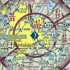
| Sectional chart |
|---|
|
CAUTION: Diagram may not be current
 Download PDF
of official airport diagram from the FAA
| Airport distance calculator |
|---|
|
|
| Sunrise and sunset |
|---|
|
Times for 17-Apr-2026
| | Local
(UTC-4) | | Zulu
(UTC) |
|---|
| Morning civil twilight | | 06:41 | | 10:41 |
| Sunrise | | 07:07 | | 11:07 |
| Sunset | | 20:14 | | 00:14 |
| Evening civil twilight | | 20:40 | | 00:40 |
|
| Current date and time |
|---|
| Zulu (UTC) | 18-Apr-2026 03:35:11 |
|---|
| Local (UTC-4) | 17-Apr-2026 23:35:11 |
|---|
|
| METAR |
|---|
| KCHA | 180253Z 17004KT 10SM SCT250 23/15 A2995 RMK AO2 SLP134 T02330150 53002
|
KDNN
20nm S | 180315Z AUTO 00000KT 8SM CLR 18/18 A2997 RMK AO2 T01780177
|
|
| TAF |
|---|
| KCHA | 171720Z 1718/1818 VRB03KT P6SM FEW050 FEW250 FM180100 00000KT P6SM SCT250 FM181600 23005KT P6SM FEW050 BKN250
|
|
| NOTAMs |
|---|
NOTAMs are issued by the DoD/FAA and will open in a separate window not controlled by AirNav.
|
|


