FAA INFORMATION EFFECTIVE 30 OCTOBER 2025
Location
| FAA Identifier: | DEW |
| Lat/Long: | 47-58-01.3970N 117-25-42.9120W
47-58.023283N 117-25.715200W
47.9670547,-117.4285867
(estimated) |
| Elevation: | 2210.7 ft. / 673.8 m (surveyed) |
| Variation: | 16E (2010) |
| From city: | 3 miles NE of DEER PARK, WA |
| Time zone: | UTC -8 (UTC -7 during Daylight Saving Time) |
| Zip code: | 99006 |
Airport Operations
| Airport use: | Open to the public |
| Activation date: | 12/1943 |
| Control tower: | no |
| ARTCC: | SEATTLE CENTER |
| FSS: | SEATTLE FLIGHT SERVICE STATION |
| NOTAMs facility: | DEW (NOTAM-D service available) |
| Attendance: | APR-OCT 0800-1700, NOV-MAR 1000-1600 |
| Pattern altitude: | GLIDER PATTERN TPA 1000 FT. |
| Wind indicator: | lighted |
| Segmented circle: | yes |
| Lights: | ACTVT REIL RWY 16 AND RWY 34; MIRL RWY 16/34 - CTAF. PAPI RWY 16 & 34 OPR CONSLY. |
| Beacon: | white-green (lighted land airport)
Operates sunset to sunrise. |
Airport Communications
| CTAF/UNICOM: | 123.0 |
| WX ASOS: | 135.175 (509-276-2303) |
| SPOKANE APPROACH: | 123.75 |
| SPOKANE DEPARTURE: | 123.75 |
| WX ASOS at SFF (18 nm S): | 120.55 (509-535-3290) |
Nearby radio navigation aids
| VOR radial/distance | | VOR name | | Freq | | Var |
|---|
| GEGr004/25.4 | | SPOKANE VORTAC | | 115.50 | | 14E |
| COEr276/27.1 | | COEUR D'ALENE VOR/DME | | 108.80 | | 19E |
| NDB name | | Hdg/Dist | | Freq | | Var | | ID |
|---|
| DEER PARK | | at field | | 365 | | 16E | | DPY | -.. .--. -.-- |
| SANDPOE | | 227/39.7 | | 264 | | 14E | | SZT | ... --.. - |
Airport Services
| Fuel available: | 100LL JET-A
100LL:100LL AND JET A AVBL 24 HRS CREDIT CARD SELF SVC FACILITY. CALL AHEAD FOR FULL SVC, JET A SVC 509-276-3379. |
| Parking: | tiedowns |
| Airframe service: | MAJOR |
| Powerplant service: | MAJOR |
| Bottled oxygen: | NONE |
| Bulk oxygen: | NONE |
Runway Information
Runway 16/34
| Dimensions: | 6101 x 75 ft. / 1860 x 23 m |
| Surface: | asphalt, in good condition |
| Weight bearing capacity: | | Single wheel: | 30.0 | | Double wheel: | 50.0 |
|
| Runway edge lights: | medium intensity |
| Runway edge markings: | RWY MRKGS FADED. |
| RUNWAY 16 | | RUNWAY 34 |
| Latitude: | 47-58.615035N | | 47-57.611675N |
| Longitude: | 117-25.872380W | | 117-25.867383W |
| Elevation: | 2210.7 ft. | | 2185.6 ft. |
| Traffic pattern: | left | | left |
| Runway heading: | 164 magnetic, 180 true | | 344 magnetic, 360 true |
| Markings: | nonprecision, in poor condition | | nonprecision, in poor condition |
| Visual slope indicator: | 4-light PAPI on left (3.50 degrees glide path) | | 4-light PAPI on left (3.00 degrees glide path) |
| Runway end identifier lights: | yes | | yes |
| Touchdown point: | yes, no lights | | yes, no lights |
| Obstructions: | 60 ft. trees, 2900 ft. from runway, 45:1 slope to clear | | none |
Runway 5/23
| Dimensions: | 3200 x 60 ft. / 975 x 18 m |
| Surface: | asphalt, in good condition |
| Weight bearing capacity: | | PCN 17 /F/C/W/T | | Single wheel: | 12.5 |
|
| RUNWAY 5 | | RUNWAY 23 |
| Latitude: | 47-57.724993N | | 47-57.978080N |
| Longitude: | 117-25.763850W | | 117-25.076797W |
| Elevation: | 2188.1 ft. | | 2183.1 ft. |
| Traffic pattern: | left | | left |
| Runway heading: | 045 magnetic, 061 true | | 225 magnetic, 241 true |
| Markings: | basic, in fair condition | | basic, in fair condition |
| Touchdown point: | yes, no lights | | yes, no lights |
Airport Ownership and Management from official FAA records
| Ownership: | Publicly-owned |
| Owner: | CITY OF DEER PARK
316 E. CRAWFORD
DEER PARK, WA 99006
Phone 509-276-8802 |
| Manager: | DAROLD SCHULTZ
PO BOX F
DEER PARK, WA 99006
Phone 509-276-3379
CELL 509-999-5835. |
Additional Remarks
| - | MONITOR GLIDER TRAFFIC ON 123.3 ABOVE 5,000 FT MSL. |
| - | FOR CD CTC SPOKANE APCH AT 509-742-2522 |
| - | MODEL AIRPLANE ACTIVITY ON ARPT. |
| - | COYOTES ON AND INVOF RUNWAYS. |
| - | RY 05/23 HEAVY GLIDER ACTIVITY ON WEEKENDS. |
| - | FARMING OPN ACTIVE ON LAND ADJACENT TO RYS. |
| - | NOISE ABATEMENT PROCEDURES IN EFFECT CTC AMGR 509-276-3379. |
| - | RY 16 PREFERRED CALM WIND RY. |
| - | 175 FT TOWER 2000 FT W OF RY 16/34. |
Instrument Procedures
NOTE: All procedures below are presented as PDF files. If you need a reader for these files, you should download the free Adobe Reader.NOT FOR NAVIGATION. Please procure official charts for flight.
FAA instrument procedures published for use from 30 October 2025 at 0901Z to 27 November 2025 at 0900Z.
IAPs - Instrument Approach Procedures |
|---|
| RNAV (GPS) RWY 16 | |
download (210KB) |
| RNAV (GPS) RWY 34 | |
download (240KB) |
| NOTE: Special Alternate Minimums apply | |
download (32KB) |
| NOTE: Special Take-Off Minimums/Departure Procedures apply | |
download (566KB) |
Other nearby airports with instrument procedures:
KSFF - Felts Field Airport (18 nm S)
KGEG - Spokane International Airport (21 nm S)
KSKA - Fairchild Air Force Base (23 nm SW)
KCOE - Coeur d'Alene Airport - Pappy Boyington Field (27 nm SE)
KSZT - Sandpoint Airport (40 nm NE)
|
|

Road maps at:
MapQuest
Bing
Google
| Aerial photo |
|---|
WARNING: Photo may not be current or correct

Do you have a better or more recent aerial photo of Deer Park Airport that you would like to share? If so, please send us your photo.
|
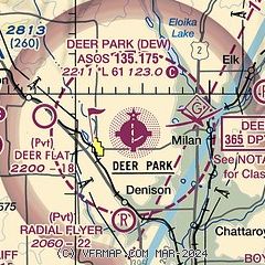
| Sectional chart |
|---|
|
| Airport distance calculator |
|---|
|
|
| Sunrise and sunset |
|---|
|
Times for 21-Nov-2025
| | Local
(UTC-8) | | Zulu
(UTC) |
|---|
| Morning civil twilight | | 06:31 | | 14:31 |
| Sunrise | | 07:06 | | 15:06 |
| Sunset | | 16:05 | | 00:05 |
| Evening civil twilight | | 16:40 | | 00:40 |
|
| Current date and time |
|---|
| Zulu (UTC) | 21-Nov-2025 16:14:56 |
|---|
| Local (UTC-8) | 21-Nov-2025 08:14:56 |
|---|
|
| METAR |
|---|
| KDEW | 211553Z AUTO 15005KT 1/2SM FG OVC002 03/03 A3020 RMK AO2 SLP241 T00280028
|
KSFF
18nm S | 211553Z 00000KT 7SM BKN007 OVC013 04/03 A3022 RMK AO2 SLP246 T00440028
|
|
| TAF |
|---|
KSFF
18nm S | 211130Z 2112/2212 23004KT 6SM BR OVC005 FM211800 22003KT P6SM OVC013 FM212200 20004KT P6SM OVC022 FM220200 VRB02KT P6SM BKN027
|
KGEG
21nm S | 211130Z 2112/2212 16004KT 2SM BR OVC002 FM211700 17005KT 5SM BR OVC006 FM211900 20006KT P6SM OVC009 FM212100 20005KT P6SM OVC013 FM220000 16004KT P6SM BKN022
|
|
| NOTAMs |
|---|
NOTAMs are issued by the DoD/FAA and will open in a separate window not controlled by AirNav.
|
|

