FAA INFORMATION EFFECTIVE 10 JULY 2025
Location
| FAA Identifier: | DLH |
| Lat/Long: | 46-50-31.4511N 092-11-35.6540W
46-50.524185N 092-11.594233W
46.8420698,-92.1932372
(estimated) |
| Elevation: | 1427.8 ft. / 435.2 m (surveyed) |
| Variation: | 01W (2020) |
| From city: | 5 miles NW of DULUTH, MN |
| Time zone: | UTC -5 (UTC -6 during Standard Time) |
| Zip code: | 55811 |
Airport Operations
| Airport use: | Open to the public |
| Activation date: | 04/1940 |
| Control tower: | yes |
| ARTCC: | MINNEAPOLIS CENTER |
| FSS: | PRINCETON FLIGHT SERVICE STATION |
| NOTAMs facility: | DLH (NOTAM-D service available) |
| Attendance: | CONTINUOUS |
| Wind indicator: | yes |
| Segmented circle: | no |
| Beacon: | white-green (lighted land airport)
Operates sunset to sunrise. |
| Landing fee: | yes, LDG FEE FOR ALL COML ACFT & ALL ACFT OVR 12500 LB MAX LDG WT EXC ACFT OPRD OR CHTRD BY THE US GOVT OR THE STATE OF MINNESOTA. |
| Fire and rescue: | ARFF index B |
| Airline operations: | ARFF INDEX D AVBL H24 WITH 2 HR PPR - CTC ANG 218-788-7434. |
| International operations: | international airport of entry |
Airport Communications
| UNICOM: | 122.95 |
| ATIS: | 124.1 270.1 |
| WX ASOS: | PHONE 218-208-0194 |
| DULUTH GROUND: | 121.9 348.6 |
| DULUTH TOWER: | 118.3 257.8 |
| DULUTH APPROACH: | 125.45 125.45 233.7 |
| DULUTH DEPARTURE: | 125.45 125.45 233.7 |
| ANG COMD POST: | 139.9 288.9 6735 ;LSB 6735 |
| EMERG: | 121.5 243.0 |
| IC: | 125.45 233.7 |
| WX AWOS-3 at DYT (9 nm SE): | 119.275 (218-720-4886) |
| WX AWOS-3 at SUW (10 nm SE): | 120.35 (715-394-0283) |
| WX AWOS-3 at COQ (15 nm SW): | 118.525 (218-879-0783) |
Nearby radio navigation aids
| VOR radial/distance | | VOR name | | Freq | | Var |
|---|
| DLHr004/2.4 | | DULUTH VORTAC | | 112.60 | | 05E |
| HIBr141/34.6 | | HIBBING VOR/DME | | 116.55 | | 02E |
| NDB name | | Hdg/Dist | | Freq | | Var | | ID |
|---|
| PYKLA | | 092/6.6 | | 379 | | 00E | | DL | -.. .-.. |
Airport Services
| Fuel available: | 100LL JET-A J8
J8:AVBL AT MIL & CIVIL FUELING FACILITIES. |
| Parking: | hangars and tiedowns |
| Airframe service: | MAJOR |
| Powerplant service: | MAJOR |
| Bottled oxygen: | HIGH/LOW |
| Bulk oxygen: | HIGH/LOW |
Runway Information
Runway 9/27
| Dimensions: | 10591 x 150 ft. / 3228 x 46 m |
| Surface: | concrete/grooved, in fair condition |
| Weight bearing capacity: | | Single wheel: | 120.0, WEIGHT BEARING STRENGTH - 2S153. | | Double wheel: | 185.0 | | Double tandem: | 320.0 | | Dual double tandem: | 763.0 |
|
| Runway edge lights: | high intensity |
| RUNWAY 9 | | RUNWAY 27 |
| Latitude: | 46-50.547302N | | 46-50.478258N |
| Longitude: | 092-13.217400W | | 092-10.680373W |
| Elevation: | 1427.8 ft. | | 1419.4 ft. |
| Traffic pattern: | left | | left |
| Runway heading: | 093 magnetic, 092 true | | 273 magnetic, 272 true |
| Displaced threshold: | no | | 529 ft. |
| Declared distances: | TORA:10591 TODA:10591 ASDA:10062 LDA:10062 | | TORA:10591 TODA:10591 ASDA:10591 LDA:10062 |
| Markings: | precision, in good condition | | precision, in good condition |
| Visual slope indicator: | 4-light PAPI on left (3.00 degrees glide path) | | 4-light PAPI on left (3.00 degrees glide path) |
| RVR equipment: | touchdown, midfield, rollout | | touchdown, midfield, rollout |
| Approach lights: | ALSF2: standard 2,400 foot high intensity approach lighting system with centerline sequenced flashers (category II or III) | | MALSR: 1,400 foot medium intensity approach lighting system with runway alignment indicator lights |
| Runway end identifier lights: | no | | no |
| Centerline lights: | yes | | yes |
| Touchdown point: | yes, lighted | | yes, no lights |
| Instrument approach: | ILS | | ILS |
| Obstructions: | 93 ft. tree, 2797 ft. from runway, 873 ft. left of centerline, 27:1 slope to clear | | 26 ft. tree, 1376 ft. from runway, 133 ft. left of centerline, 45:1 slope to clear |
Runway 3/21
| Dimensions: | 5719 x 150 ft. / 1743 x 46 m |
| Surface: | asphalt/grooved, in good condition |
| Weight bearing capacity: | | Single wheel: | 101.0, WEIGHT BEARING STRENGTH - 2S127. | | Double wheel: | 168.0 | | Double tandem: | 282.0 |
|
| Runway edge lights: | medium intensity |
| RUNWAY 3 | | RUNWAY 21 |
| Latitude: | 46-50.144437N | | 46-50.946172N |
| Longitude: | 092-11.296187W | | 092-10.578715W |
| Elevation: | 1413.7 ft. | | 1416.0 ft. |
| Traffic pattern: | left | | left |
| Runway heading: | 033 magnetic, 032 true | | 213 magnetic, 212 true |
| Declared distances: | TORA:5719 TODA:5719 ASDA:5719 LDA:5719 | | TORA:5719 TODA:5719 ASDA:5719 LDA:5719 |
| Markings: | nonprecision, in good condition | | nonprecision, in good condition |
| Visual slope indicator: | 4-light PAPI on left (3.00 degrees glide path) | | 4-light PAPI on left (3.00 degrees glide path) |
| Runway end identifier lights: | yes | | yes |
| Touchdown point: | yes, no lights | | yes, no lights |
| Obstructions: | 51 ft. tree, 2194 ft. from runway, 217 ft. right of centerline, 39:1 slope to clear | | 30 ft. tree, 1289 ft. from runway, 324 ft. left of centerline, 36:1 slope to clear |
Airport Ownership and Management from official FAA records
| Ownership: | Publicly-owned |
| Owner: | CITY OF DULUTH, MINNESOTA
4701 GRINDEN DR
DULUTH, MN 55811-1578
Phone 218-625-7766 |
| Manager: | MARK PAPKO, DIRECTOR OF OPERATIONS
4701 GRINDEN DR
DULUTH, MN 55811-1578
Phone 218-727-2968 |
Additional Remarks
| A39-09/27 | PCR VALUE: 570/R/B/W/T |
| A39-03/21 | PCR VALUE: 400/F/B/X/T |
| A30A-27 | CAUTION: WINDSHEAR/DOWNDRAFTS FINAL APCH. |
| E60-27 | TYPE H BAK 12B(B) 2544 FT. |
| E60-09 | TYPE H BAK-12B(B) 1470 FT. |
| - | BIRDS ON & INVOF ARPT. |
| - | JASU: 9(AM32A-60) 2(A/M32A-86) 2(MC-11) 6(MC-2A) (MIL). |
| - | SP DE-ICE LHOX LHNIT. |
| - | OIL: O-148(MIL). JOAP. |
| - | CAUTION: BIRD HAZ. (PHASE II CONDITIONS) EXISTS DUR 1 SEP THRU 31 OCT. CTC SOF/AFLD MGR/COMD POST FOR INFO. |
| - | FLIGHT NOTIFICATION SERVICE (ADCUS) AVBL. |
| - | TAXI LANE G MAY BE USED AS ALTERNATE TAXI ROUTE. |
| - | FUEL: A+, J8 (MONACO AIR DULUTH, C218-727-2911.) (NC-100LL, A). A++(MIL) (ANG, C218-788-7340). |
| - | PPR ALL ACFT. OPR 1200-2130Z++ MON-FRI, EXC HOL AND FLEX DAYS. LTD OPR HR AND TRAN SVC AVBL. CTC AFLD MGT DSN 825-7252, C218-788-7252, OPS DESK DSN 825-7399, C218-788-7399, COMD POST DSN 825-7370/7371, C218-788-7370/7371. FTR ACFT AND C12/C21 CARGO ACFT MAY ENTER ANG RAMP VIA TWY E OR H. ALL OTHER NON-FTR ACFT USE TWY F TO ENTER ANG RAMP. PER GIANT REPORT, TWY F CURRENTLY RSTD TO ONLY C17/C130 ACFT. ALL OTHER CARGO AMC ACFT MUST PARK AT MIDFIELD RAMP. ALL TRAN ACFT WILL CTC COMD POST 15 MIN PRIOR TO LDG. TRAN ACFT WILL CTC COMD POST BEFORE ENGINE STARTUP AND BEFORE TAXI. NO SVC AVAILABLE WHEN WIND CHILL EXCEEDS OR IS FCST TO EXCEED -30-F. FOR RCR INFO, AFLD STATUS AND CRASH RESCUE CAPABILITY CTC COMD POST OR TWR. NONSTD MRK FOR ALERT/MAINT VEH, ACFT GND EQPT PRK SPOTS. |
| - | TWY C BTWN TWY A & D CLSD 1 OCT THRU 30 APR. |
| - | ACFT DEICE TYPE 1 & 4 FLUID AVBL - CTC FBO C218-727-2911. |
| - | US CUST INTL AOE (NO FEES) AVBL H24 C218-720-5203 THEN PRESS 0. CUST CLEARING LCTD AT FBO. |
| - | FOR MIL TSNT ACFT PRKG, RFLG, & SER OFF ANG CTC FBO C218-727-2977 H24. |
| - | HIGH SPEED MILITARY JET TRAFFIC NOT ON ADS-B OPERATING IN AND ABOVE CLASS D AIRSPACE FROM 3000' TO 11,500' MSL CTC DLH APP FOR TRFC ADZYS FOR TRANSIT RCMDD. |
| - | WHEN RWY 03/21 IN USE; TWY C NORTH OF RWY 09/27 MAY BE RESTRICTED BY ATC TO ACFT WITH WINGSPANS LESS THAN 49 FT. |
Instrument Procedures
NOTE: All procedures below are presented as PDF files. If you need a reader for these files, you should download the free Adobe Reader.NOT FOR NAVIGATION. Please procure official charts for flight.
FAA instrument procedures published for use from 10 July 2025 at 0901Z to 07 August 2025 at 0900z.
IAPs - Instrument Approach Procedures |
|---|
| ILS OR LOC RWY 09 | |
download (286KB) |
| ILS OR LOC RWY 27 | |
download (317KB) |
| ILS RWY 09 (SA CAT I) | |
download (258KB) |
| ILS RWY 09 (SA CAT I) | |
download (258KB) |
| ILS RWY 09 (CAT II) | |
download (248KB) |
| RNAV (GPS) RWY 03 | |
download (247KB) |
| RNAV (GPS) RWY 09 | |
download (301KB) |
| RNAV (GPS) RWY 21 | |
download (241KB) |
| RNAV (GPS) RWY 27 | |
download (256KB) |
| VOR/DME OR TACAN RWY 21 | |
download (253KB) |
| VOR OR TACAN RWY 03 | |
download (227KB) |
| HI-TACAN Z RWY 09 | |
download (163KB) |
| TACAN Y RWY 09 | |
download (258KB) |
| Radar Approach Procedures available | |
download (139KB) |
| NOTE: Special Alternate Minimums apply | |
download (175KB) |
| NOTE: Special Take-Off Minimums/Departure Procedures apply | |
download (411KB) |
Other nearby airports with instrument procedures:
KDYT - Sky Harbor Airport (9 nm SE)
KSUW - Richard I Bong Airport (10 nm SE)
KCOQ - Cloquet/Carlton County Airport (15 nm SW)
KTWM - Richard B Helgeson Airport (22 nm NE)
KOLG - Solon Springs Municipal Airport (35 nm SE)
|
|

Road maps at:
MapQuest
Bing
Google
| Aerial photo |
|---|
WARNING: Photo may not be current or correct
 Photo by Stuart King
Photo taken 10-Jun-2011
looking north.
Photo by Stuart King
Photo taken 10-Jun-2011
looking north.
Do you have a better or more recent aerial photo of Duluth International Airport that you would like to share? If so, please send us your photo.
|
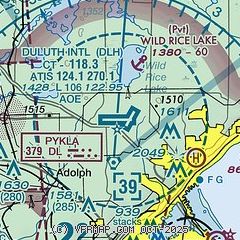
| Sectional chart |
|---|
|
CAUTION: Diagram may not be current
 Download PDF
of official airport diagram from the FAA
| Airport distance calculator |
|---|
|
|
| Sunrise and sunset |
|---|
|
Times for 20-Jul-2025
| | Local
(UTC-5) | | Zulu
(UTC) |
|---|
| Morning civil twilight | | 04:59 | | 09:59 |
| Sunrise | | 05:36 | | 10:36 |
| Sunset | | 20:54 | | 01:54 |
| Evening civil twilight | | 21:32 | | 02:32 |
|
| Current date and time |
|---|
| Zulu (UTC) | 20-Jul-2025 20:51:40 |
|---|
| Local (UTC-5) | 20-Jul-2025 15:51:40 |
|---|
|
| METAR |
|---|
| KDLH | 201955Z 07006KT 4SM HZ FU BKN120 22/11 A3009 RMK AO2 SLP189 T02170111 $
|
KDYT
10nm SE | 202035Z AUTO VRB04KT 6SM HZ CLR 19/15 A3006 RMK AO2
|
KCOQ
15nm SW | 202035Z AUTO 07006KT 7SM CLR 22/11 A3007 RMK AO2 TSNO
|
|
| TAF |
|---|
| KDLH | 201739Z 2018/2118 10007KT 5SM FU BKN100 FM210000 10007KT 6SM HZ BKN100 FM211400 14008KT 4SM FU BKN100
|
|
| NOTAMs |
|---|
NOTAMs are issued by the DoD/FAA and will open in a separate window not controlled by AirNav.
|
|


