FAA INFORMATION EFFECTIVE 16 APRIL 2026
Location
| FAA Identifier: | EAU |
| Lat/Long: | 44-51-56.9000N 091-29-03.3000W
44-51.948333N 091-29.055000W
44.8658056,-91.4842500
(estimated) |
| Elevation: | 913.1 ft. / 278.3 m (surveyed) |
| Variation: | 01E (1995) |
| From city: | 3 miles N of EAU CLAIRE, WI |
| Time zone: | UTC -5 (UTC -6 during Standard Time) |
| Zip code: | 54703 |
Airport Operations
| Airport use: | Open to the public |
| Activation date: | 11/1944 |
| Control tower: | yes |
| ARTCC: | MINNEAPOLIS CENTER |
| FSS: | GREEN BAY FLIGHT SERVICE STATION |
| NOTAMs facility: | EAU (NOTAM-D service available) |
| Attendance: | 0700-2100
OTHER ATTENDANCE TIMES CALL 715-839-4900. |
| Wind indicator: | lighted |
| Segmented circle: | yes |
| Lights: | WHEN ATCT CLSD HIRL RY 04/22 PRESET ON LOW INTST; TO INCR INTST & ACTVT MALSR RY 22; REIL RWY 4; HIRL RY 04/22; REIL RY 14; PAPI RYS 14 /32; MIRL RY 14/32 - CTAF. |
| Beacon: | white-green (lighted land airport)
Operates sunset to sunrise. |
| Fire and rescue: | ARFF index B |
| Airline operations: | ARFF NOT AVBL 24 HRS. PPR FOR UNSCHEDULED ACR OPNS WITH MORE THAN 9 PASSENGER SEATS; CONTACT ARPT MGR 715-839-6241. ACR OPNS WITH MORE THAN 9 PASSENGER SEATS NA IN EXCESS OF 15 MIN BEFORE OR AFTER SKED ARR/DEP TIMES WITHOUT PPR WITH ARPT MGR AND CONFIRMATION ARFF IS AVLB PRIOR TO LDG OR TKF. |
Airport Communications
| CTAF: | 118.575 |
| UNICOM: | 122.95 |
| ATIS: | 126.025 |
| WX ASOS: | 126.025 (715-832-7990) |
| EAU CLAIRE GROUND: | 120.925 [0530-2030] |
| EAU CLAIRE TOWER: | 118.575 [0530-2030] |
| WX AWOS-3PT at LUM (16 nm W): | 118.025 |
- APCH/DEP SVC PRVDD BY MINNEAPOLIS ARTCC ON FREQS 125.3/335.6 (EAU CLAIRE RCAG).
- DEPARTURE CLEARANCE THROUGH EAU CLAIRE FSS ON FREQ 123.6.
Nearby radio navigation aids
| VOR radial/distance | | VOR name | | Freq | | Var |
|---|
| EAUr183/1.9 | | EAU CLAIRE VORTAC | | 113.65 | | 04E |
Airport Services
| Fuel available: | 100LL JET-A |
| Parking: | hangars and tiedowns |
| Airframe service: | MAJOR |
| Powerplant service: | MAJOR |
| Bottled oxygen: | LOW |
Runway Information
Runway 4/22
| Dimensions: | 8101 x 150 ft. / 2469 x 46 m |
| Surface: | concrete/grooved, in good condition |
| Weight bearing capacity: | | Single wheel: | 100.0 | | Double wheel: | 130.0 | | Double tandem: | 220.0 |
|
| Runway edge lights: | high intensity |
| RUNWAY 4 | | RUNWAY 22 |
| Latitude: | 44-51.557188N | | 44-52.500233N |
| Longitude: | 091-29.562960W | | 091-28.238072W |
| Elevation: | 886.6 ft. | | 913.1 ft. |
| Traffic pattern: | left | | left |
| Runway heading: | 044 magnetic, 045 true | | 224 magnetic, 225 true |
| Displaced threshold: | 400 ft. | | no |
| Declared distances: | TORA:8101 TODA:8101 ASDA:8101 LDA:7701 | | TORA:8101 TODA:8101 ASDA:7301 LDA:7301 |
| Markings: | precision, in good condition | | precision, in good condition |
| Visual slope indicator: | 4-light PAPI on left (3.00 degrees glide path)
PAPI RY 04 AND RY 22 OPERATE 24 HRS. | | 4-light PAPI on left (3.00 degrees glide path) |
| Approach lights: | | | MALSR: 1,400 foot medium intensity approach lighting system with runway alignment indicator lights |
| Runway end identifier lights: | yes | | no |
| Touchdown point: | yes, no lights | | yes, no lights |
| Instrument approach: | | | ILS/DME |
| Obstructions: | 4 ft. road, 140 ft. from runway, 481 ft. left of centerline
ROAD 140 FT FM RWY END 481 FT LEFT OF CNTRLN. | | none |
Runway 14/32
| Dimensions: | 5000 x 100 ft. / 1524 x 30 m |
| Surface: | concrete/grooved, in fair condition |
| Weight bearing capacity: | | Single wheel: | 55.0 | | Double wheel: | 70.0 | | Double tandem: | 125.0 |
|
| Runway edge lights: | medium intensity |
| RUNWAY 14 | | RUNWAY 32 |
| Latitude: | 44-52.128127N | | 44-51.507508N |
| Longitude: | 091-29.685858W | | 091-28.926232W |
| Elevation: | 882.8 ft. | | 887.6 ft. |
| Traffic pattern: | left | | left |
| Runway heading: | 138 magnetic, 139 true | | 318 magnetic, 319 true |
| Declared distances: | TORA:5000 TODA:5000 ASDA:5000 LDA:5000 | | TORA:5000 TODA:5000 ASDA:5000 LDA:5000 |
| Markings: | nonprecision, in good condition | | nonprecision, in good condition |
| Visual slope indicator: | 4-light PAPI on left (3.00 degrees glide path) | | 4-light PAPI on left (4.00 degrees glide path) |
| Runway end identifier lights: | yes | | |
| Touchdown point: | yes, no lights | | yes, no lights |
Airport Ownership and Management from official FAA records
| Ownership: | Publicly-owned |
| Owner: | EAU CLAIRE COUNTY
721 OXFORD AVE
EAU CLAIRE, WI 54701
Phone 715-839-4900 |
| Manager: | CHARITY ZICH
3800 STARR AVE
EAU CLAIRE, WI 54703
Phone 715-839-6241
EMAIL ADDRESS: ADMIN@CHIPPEWAVALLEYAIRPORT.COM (ALL LOWER CASE) |
Additional Remarks
| A39-14/32 | PCR VALUE: 190/R/C/W/T |
| A39-04/22 | PCR VALUE: 420/R/C/W/T |
| - | ARPT CONDS UNMON 2200 - 0500. |
| - | DEER & BIRDS ON & INVOF ARPT. |
| - | FOR CD IF UNA TO CTC ON FSS FREQ, CTC MINNEAPOLIS ARTCC AT 651-463-5588. |
| - | ALL GA ACFT PARK AT FBO. |
Instrument Procedures
NOTE: All procedures below are presented as PDF files. If you need a reader for these files, you should download the free Adobe Reader.NOT FOR NAVIGATION. Please procure official charts for flight.
FAA instrument procedures published for use from 16 April 2026 at 0901Z to 14 May 2026 at 0900Z.
IAPs - Instrument Approach Procedures |
|---|
| ILS OR LOC RWY 22 | |
download (315KB) |
| RNAV (GPS) RWY 04 | |
download (290KB) |
| RNAV (GPS) RWY 22 | |
download (298KB) |
| LOC BC RWY 04 | |
download (284KB) |
| VOR-A | |
download (230KB) |
| NOTE: Special Alternate Minimums apply | |
download (141KB) |
| NOTE: Special Take-Off Minimums/Departure Procedures apply | |
download (486KB) |
Other nearby airports with instrument procedures:
KLUM - Menomonie Municipal Airport-Score Field (16 nm W)
3T3 - Boyceville Municipal Airport (25 nm NW)
Y23 - Chetek Municipal/Southworth Airport (27 nm N)
KRPD - Rice Lake Regional Airport - Carl's Field (35 nm N)
KRCX - Rusk County Airport (43 nm NE)
|
|

Road maps at:
MapQuest
Bing
Google
| Aerial photo |
|---|
WARNING: Photo may not be current or correct
 Photo by Lyle D Pahnke
Photo taken 27-Jul-2018
from 4000 ft looking southwest.
Photo by Lyle D Pahnke
Photo taken 27-Jul-2018
from 4000 ft looking southwest.
Do you have a better or more recent aerial photo of Chippewa Valley Regional Airport that you would like to share? If so, please send us your photo.
|
| Sectional chart |
|---|
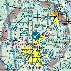
|
| Airport distance calculator |
|---|
|
|
| Sunrise and sunset |
|---|
|
Times for 07-May-2026
| | Local
(UTC-5) | | Zulu
(UTC) |
|---|
| Morning civil twilight | | 05:15 | | 10:15 |
| Sunrise | | 05:48 | | 10:48 |
| Sunset | | 20:17 | | 01:17 |
| Evening civil twilight | | 20:50 | | 01:50 |
|
| Current date and time |
|---|
| Zulu (UTC) | 07-May-2026 06:24:52 |
|---|
| Local (UTC-5) | 07-May-2026 01:24:52 |
|---|
|
| METAR |
|---|
| KEAU | 070556Z AUTO 19003KT 10SM OVC065 04/M03 A2994 RMK AO2 SLP145 T00391033 10061 20039 400671011 57012
|
KLUM
16nm W | 070555Z AUTO 00000KT 10SM OVC070 03/M02 A2995 RMK AO2 T00271019 10070 20022 400730006 PWINO
|
|
| TAF |
|---|
| KEAU | 070520Z 0706/0806 VRB03KT P6SM BKN060 FM071600 29008KT P6SM SCT060 FM080200 VRB03KT P6SM FEW250
|
|
| NOTAMs |
|---|
NOTAMs are issued by the DoD/FAA and will open in a separate window not controlled by AirNav.
|
|

