FAA INFORMATION EFFECTIVE 30 OCTOBER 2025
Location
| FAA Identifier: | EHA |
| Lat/Long: | 37-00-02.8160N 101-52-48.1000W
37-00.046933N 101-52.801667W
37.0007822,-101.8800278
(estimated) |
| Elevation: | 3621.9 ft. / 1104.0 m (surveyed) |
| Variation: | 07E (2010) |
| From city: | 1 mile E of ELKHART, KS |
| Time zone: | UTC -5 (UTC -6 during Standard Time) |
| Zip code: | 67950 |
Airport Operations
| Airport use: | Open to the public |
| Activation date: | 01/1942 |
| Control tower: | no |
| ARTCC: | KANSAS CITY CENTER |
| FSS: | WICHITA FLIGHT SERVICE STATION |
| NOTAMs facility: | ICT (NOTAM-D service available) |
| Attendance: | UNATNDD |
| Wind indicator: | lighted |
| Segmented circle: | yes |
| Lights: | ACTVT PAPI RWY 04, 17, 22 & 35; MIRL RWY 04/22 & 17/35 - CTAF. |
| Beacon: | white-green (lighted land airport)
Operates sunset to sunrise. |
Airport Communications
| CTAF/UNICOM: | 122.8 |
| WX AWOS-3P: | 118.025 (620-697-4973) |
- APCH/DEP CTL SVC PRVDD BY KANSAS CITY ARTCC (ZKC) ON FREQS 134.0/257.625 (LIBERAL RCAG).
Nearby radio navigation aids
| NDB name | | Hdg/Dist | | Freq | | Var | | ID |
|---|
| GUYMON | | 306/25.3 | | 275 | | 09E | | GUY | --. ..- -.-- |
Airport Services
| Fuel available: | 100LL
100LL:FOR FUEL CALL (620) 697-2803. |
| Parking: | hangars and tiedowns |
| Bottled oxygen: | NONE |
| Bulk oxygen: | NONE |
Runway Information
Runway 17/35
| Dimensions: | 4907 x 75 ft. / 1496 x 23 m |
| Surface: | concrete, in excellent condition |
| Weight bearing capacity: | | PCN 11 /R/C/X/U | | Single wheel: | 30.0 | | Double wheel: | 30.0 |
|
| Runway edge lights: | medium intensity |
| RUNWAY 17 | | RUNWAY 35 |
| Latitude: | 37-00.517313N | | 36-59.708843N |
| Longitude: | 101-52.934180W | | 101-52.921925W |
| Elevation: | 3607.6 ft. | | 3617.6 ft. |
| Traffic pattern: | left | | right |
| Runway heading: | 172 magnetic, 179 true | | 352 magnetic, 359 true |
| Markings: | nonprecision, in good condition | | nonprecision, in good condition |
| Visual slope indicator: | 4-light PAPI on left (3.00 degrees glide path) | | 4-light PAPI on left (3.00 degrees glide path) |
| Touchdown point: | yes, no lights | | yes, no lights |
| Obstructions: | 18 ft. pole, 917 ft. from runway, 100 ft. right of centerline, 39:1 slope to clear | | 15 ft. road, 506 ft. from runway, 20:1 slope to clear |
Runway 4/22
| Dimensions: | 4900 x 60 ft. / 1494 x 18 m |
| Surface: | asphalt, in fair condition |
| Weight bearing capacity: | |
| Runway edge lights: | medium intensity |
| RUNWAY 4 | | RUNWAY 22 |
| Latitude: | 36-59.712842N | | 37-00.248512N |
| Longitude: | 101-53.051200W | | 101-52.298152W |
| Elevation: | 3621.8 ft. | | 3594.1 ft. |
| Traffic pattern: | right | | left |
| Runway heading: | 041 magnetic, 048 true | | 221 magnetic, 228 true |
| Markings: | nonprecision, in good condition | | nonprecision, in good condition |
| Visual slope indicator: | 4-light PAPI on left (3.00 degrees glide path) | | 4-light PAPI on left (3.00 degrees glide path) |
| Touchdown point: | yes, no lights | | yes, no lights |
| Obstructions: | 15 ft. road, 546 ft. from runway, 23:1 slope to clear | | 21 ft. tower, 279 ft. from runway, 3:1 slope to clear
PIVOT IRRIGATION TWR (MOVING WHEN IN OPN). |
Airport Ownership and Management from official FAA records
| Ownership: | Publicly-owned |
| Owner: | MORTON COUNTY
P.O. BOX 1116
ELKHART, KS 67950
Phone 620-697-2157 |
| Manager: | DENNIS TEVEBAUGH
PO BOX 392
ELKHART, KS 67950
Phone (620) 360-6100
CELL PHONE # 620-360-3600. |
Additional Remarks
| - | PUBLIC PHONE (620) 697-9803. |
| - | FOR CD CTC KANSAS CITY ARTCC AT 913-254-8508. |
Instrument Procedures
NOTE: All procedures below are presented as PDF files. If you need a reader for these files, you should download the free Adobe Reader.NOT FOR NAVIGATION. Please procure official charts for flight.
FAA instrument procedures published for use from 30 October 2025 at 0901Z to 27 November 2025 at 0900Z.
IAPs - Instrument Approach Procedures |
|---|
| RNAV (GPS) RWY 04 | |
download (178KB) |
| RNAV (GPS) RWY 17 | |
download (182KB) |
| RNAV (GPS) RWY 22 | |
download (179KB) |
| RNAV (GPS) RWY 35 | |
download (200KB) |
| NOTE: Special Alternate Minimums apply | |
download (140KB) |
| NOTE: Special Take-Off Minimums/Departure Procedures apply | |
download (147KB) |
Other nearby airports with instrument procedures:
KGUY - Guymon Municipal Airport (26 nm SE)
KHQG - Hugoton Municipal Airport (26 nm E)
17K - Boise City Airport (33 nm SW)
KJHN - Stanton County Municipal Airport (36 nm N)
KULS - Ulysses Airport (44 nm NE)
|
|

Road maps at:
MapQuest
Bing
Google
| Aerial photo |
|---|
WARNING: Photo may not be current or correct
 Photo by Von Rothenberger
Photo taken 14-Aug-2010
looking north.
Photo by Von Rothenberger
Photo taken 14-Aug-2010
looking north.
Do you have a better or more recent aerial photo of Elkhart-Morton County Airport that you would like to share? If so, please send us your photo.
|
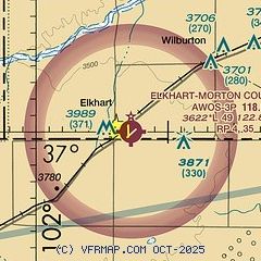
| Sectional chart |
|---|
|
| Airport distance calculator |
|---|
|
|
| Sunrise and sunset |
|---|
|
Times for 01-Nov-2025
| | Local
(UTC-5) | | Zulu
(UTC) |
|---|
| Morning civil twilight | | 07:46 | | 12:46 |
| Sunrise | | 08:13 | | 13:13 |
| Sunset | | 18:50 | | 23:50 |
| Evening civil twilight | | 19:16 | | 00:16 |
|
| Current date and time |
|---|
| Zulu (UTC) | 01-Nov-2025 07:32:30 |
|---|
| Local (UTC-5) | 01-Nov-2025 02:32:30 |
|---|
|
| METAR |
|---|
| KEHA | 010650Z AUTO 34007KT 10SM SCT120 01/M02 A3021 RMK AO2 T00071016
|
|
| TAF |
|---|
KGUY
26nm SE | 010520Z 0106/0206 03009KT P6SM SCT200 FM011000 VRB05KT P6SM SKC
|
|
| NOTAMs |
|---|
NOTAMs are issued by the DoD/FAA and will open in a separate window not controlled by AirNav.
|
|


