FAA INFORMATION EFFECTIVE 19 FEBRUARY 2026
Location
| FAA Identifier: | FMY |
| Lat/Long: | 26-35-11.8150N 081-51-47.6880W
26-35.196917N 081-51.794800W
26.5866153,-81.8632467
(estimated) |
| Elevation: | 17 ft. / 5.2 m (surveyed) |
| Variation: | 03W (1990) |
| From city: | 3 miles S of FORT MYERS, FL |
| Time zone: | UTC -5 (UTC -4 during Daylight Saving Time) |
| Zip code: | 33907 |
Airport Operations
| Airport use: | Open to the public |
| Activation date: | 04/1940 |
| Control tower: | yes |
| ARTCC: | MIAMI CENTER |
| FSS: | MIAMI FLIGHT SERVICE STATION |
| NOTAMs facility: | FMY (NOTAM-D service available) |
| Attendance: | 0700-2000 |
| Wind indicator: | lighted |
| Segmented circle: | yes |
| Lights: | WHEN ATCT CLSD, ACTVT REIL RWY 5, 13, 23, & 31; PAPI RWY 5, 13, 23, & 31; MIRL RWY 5/23 & 13/31 - CTAF. |
| Beacon: | white-green (lighted land airport)
Operates sunset to sunrise. |
| Landing fee: | yes |
Airport Communications
| CTAF: | 119.0 |
| ATIS: | 123.725 |
| WX ASOS: | 123.725 (239-936-2318) |
| PAGE GROUND: | 121.7 [0700-2200] |
| PAGE TOWER: | 119.0 306.95 [0700-2200] |
| FORT MYERS APPROACH: | 126.8 125.15 ;RWY 05/13 126.8 126.8 ;RWY 23/31 |
| FORT MYERS DEPARTURE: | 126.8 126.8 |
| CLEARANCE DELIVERY: | 121.7 |
| IC: | 125.15 ;RWY 05/13 126.8 ;RWY 23/31 |
| JOSFF STAR: | 134.425 |
| PUMPP STAR: | 134.425 |
| SHFTY STAR: | 126.8 |
| TYNEE STAR: | 134.425 |
| VFR ADZY: | 119.0 |
| WX ASOS at RSW (7 nm SE): | 124.65 (239-416-1031) |
- AIR TO FBO COMM AVBL ON 130.55.
- APCH/DEP SVC PRVDD BY MIAMI ARTCC ON FREQS 134.75/322.5 (FORT MYERS RCAG) WHEN FORT MYERS APCH CTL CLSD.
Nearby radio navigation aids
| VOR radial/distance | | VOR name | | Freq | | Var |
|---|
| RSWr308/5.8 | | LEE COUNTY VORTAC | | 114.15 | | 02W |
| NDB name | | Hdg/Dist | | Freq | | Var | | ID |
|---|
| CALOO | | 051/6.3 | | 341 | | 03W | | FM | ..-. -- |
Airport Services
| Fuel available: | 100LL JET-A |
| Parking: | hangars and tiedowns |
| Airframe service: | MAJOR |
| Powerplant service: | MAJOR |
| Bottled oxygen: | HIGH/LOW |
| Bulk oxygen: | HIGH/LOW |
Runway Information
Runway 5/23
| Dimensions: | 6406 x 150 ft. / 1953 x 46 m |
| Surface: | asphalt/grooved, in excellent condition |
| Weight bearing capacity: | | PCN 32 /F/A/X/T | | Single wheel: | 83.0 | | Double wheel: | 126.0 |
|
| Runway edge lights: | medium intensity |
| RUNWAY 5 | | RUNWAY 23 |
| Latitude: | 26-34.800487N | | 26-35.509942N |
| Longitude: | 081-52.265662W | | 081-51.393558W |
| Elevation: | 12.7 ft. | | 17.0 ft. |
| Traffic pattern: | left | | left |
| Runway heading: | 051 magnetic, 048 true | | 231 magnetic, 228 true |
| Displaced threshold: | 461 ft. | | 401 ft. |
| Declared distances: | TORA:6406 TODA:6406 ASDA:6005 LDA:5545 | | TORA:6406 TODA:6406 ASDA:5946 LDA:5545 |
| Markings: | precision, in fair condition | | precision, in fair condition |
| Visual slope indicator: | 4-light PAPI on left (3.00 degrees glide path) | | 4-light PAPI on left (3.00 degrees glide path) |
| Runway end identifier lights: | yes | | yes |
| Touchdown point: | yes, no lights | | yes, no lights |
| Instrument approach: | ILS | | |
| Obstructions: | 15 ft. road, marked and lighted, 200 ft. from runway, 125 ft. left of centerline, 1:1 slope to clear
RWY 05 HAS 6 FT FENCE & 15 FT ROAD 185 FT FM RWY END. | | 23 ft. rr, lighted, 180 ft. from runway, 500 ft. left of centerline
RWY 23 HAS 23 FT RR 180 FT FM END OF RWY, 500 FT LEFT OF CNTRLN. |
Runway 13/31
| Dimensions: | 4910 x 150 ft. / 1497 x 46 m |
| Surface: | asphalt/grooved, in excellent condition |
| Weight bearing capacity: | | PCN 17 /F/A/X/T | | Single wheel: | 42.5 | | Double wheel: | 63.0 |
|
| Runway edge lights: | medium intensity |
| RUNWAY 13 | | RUNWAY 31 |
| Latitude: | 26-35.514330N | | 26-34.988253N |
| Longitude: | 081-52.092165W | | 081-51.406542W |
| Elevation: | 13.9 ft. | | 14.8 ft. |
| Traffic pattern: | left | | left |
| Runway heading: | 133 magnetic, 130 true | | 313 magnetic, 310 true |
| Displaced threshold: | 614 ft. | | no |
| Declared distances: | TORA:4910 TODA:4910 ASDA:4910 LDA:4296 | | TORA:4705 TODA:4910 ASDA:4705 LDA:4705 |
| Markings: | nonprecision, in good condition | | nonprecision, in good condition |
| Visual slope indicator: | 4-light PAPI on left (3.00 degrees glide path) | | 4-light PAPI on right (3.00 degrees glide path) |
| Runway end identifier lights: | yes | | yes |
| Touchdown point: | yes, no lights | | yes, no lights |
| Obstructions: | 15 ft. road, marked and lighted, 200 ft. from runway, 1:1 slope to clear
15 FT BLAST FENCE & ROAD END OF RY. | | 24 ft. rr, marked and lighted, 545 ft. from runway, 250 ft. right of centerline, 14:1 slope to clear
RWY 31 APCH SLOPE 34:1 TO AER. |
Airport Ownership and Management from official FAA records
| Ownership: | Publicly-owned |
| Owner: | LEE COUNTY PORT AUTHORITY
11000 TERMINAL ACCESS RD SUITE 8671
FORT MYERS, FL 33913
Phone 239-590-4700
CTC PERSON: STEVE HENNIGAN 239-590-4700 |
| Manager: | SCOTT SHEETS
5200 CAPTAIN CHANNING PAGE DRIVE
FORT MYERS, FL 33907
Phone 239-590-6601
AIRPORT PHYSICAL ADDRESS: 5200 CAPT. CHANNING PAGE DRIVE. |
Additional Remarks
| - | HIGH DENSITY BIRD POPULATION WITHIN THE ARPT BOUNDARIES. |
| - | ACFT ON ALL RAMPS CTC GC PRIOR TO TAXI. |
| - | FOR CD IF UNA TO CTC ON FSS FREQ, CTC FT MYERS APCH AT 239-416-1026, WHEN APCH CLSD CTC MIAMI ARTCC AT 305-716-1731. |
| - | TWY E2 BTN TWY E AND WEST RAMP CLSD TO ACFT WINGSPAN MORE THAN 79 FT. |
| - | WEST RAMP IS DSGND AS THE FBO RAMP. ALL OTR RAMPS ARE DSGND AS GA TENANT RAMPS. |
| - | TWY D CLSD TO ACFT WINGSPAN MORE THAN 79 FT. |
| - | SELF SERVE FUEL RAMP CLSD TO ACFT WINGSPAN MORE THAN 49 FT. |
| - | 24 HR P PR FOR ACFT EQUIPPED WITH WEATHER MODIFICATION OR GEOENGINEERING EQPT 239-590-4810. |
| - | BRIGHTLY LGTD BALL FIELD 1500 FT SE OF AER 05. |
| - | NOISE SENSITIVE AIRPORT - VOLUNTARY RESTRICTION FOR LARGE AIRCRAFT AND JET AIRCRAFT CONDUCTING MULTIPLE APPROACHES AND/OR CLOSED TRAFFIC. |
| - | TWY 'B' SE OF TWY 'A' IS NON-MOVEMENT AREA NOT VSB FM ATCT. |
| - | PAEW ADJ TO RYS & TWYS DURING DALGT HRS. |
| - | NO SKED COML PSGN OPNS. FOR INFO CALL AMGR 239-590-6600. |
| - | TAXILANE D FROM D-3 TO TWY A IS A NON-MOVEMENT AREA. |
Instrument Procedures
NOTE: All procedures below are presented as PDF files. If you need a reader for these files, you should download the free Adobe Reader.NOT FOR NAVIGATION. Please procure official charts for flight.
FAA instrument procedures published for use from 19 February 2026 at 0901Z to 19 March 2026 at 0900Z.
STARs - Standard Terminal Arrivals |
|---|
| PUMPP TWO | |
download (133KB) |
| SHFTY SIX (RNAV) | |
2 pages:
[1] [2] (476KB) |
| TYNEE FOUR (RNAV) | |
2 pages:
[1] [2] (388KB) |
IAPs - Instrument Approach Procedures |
|---|
| ILS OR LOC RWY 05 | |
download (282KB) |
| RNAV (GPS) RWY 05 | |
download (291KB) |
| RNAV (GPS) RWY 13 | |
download (297KB) |
| RNAV (GPS) RWY 23 | |
download (258KB) |
| RNAV (GPS) RWY 31 | |
download (268KB) |
| NOTE: Special Alternate Minimums apply **CHANGED** | |
download (146KB) |
Departure Procedures |
|---|
| CSHEL EIGHT (RNAV) **NEW** | |
download (226KB) |
| NOTE: Special Take-Off Minimums/Departure Procedures apply | |
download (408KB) |
Other nearby airports with instrument procedures:
KRSW - Southwest Florida International Airport (7 nm SE)
KPGD - Punta Gorda Airport (21 nm N)
X14 - La Belle Municipal Airport (25 nm E)
FA54 - Coral Creek Airport (26 nm NW)
KAPF - Naples Municipal Airport (26 nm S)
|
|

Road maps at:
MapQuest
Bing
Google
| Aerial photo |
|---|
WARNING: Photo may not be current or correct
 Photo courtesy of Europe-American Aviation
Photo taken 17-Oct-2012
looking northeast at 6,000 feet.
Photo courtesy of Europe-American Aviation
Photo taken 17-Oct-2012
looking northeast at 6,000 feet.
Do you have a better or more recent aerial photo of Page Field Airport that you would like to share? If so, please send us your photo.
|
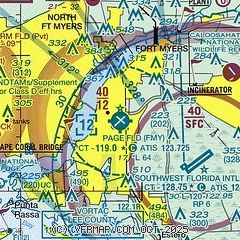
| Sectional chart |
|---|
|
CAUTION: Diagram may not be current
 Download PDF
of official airport diagram from the FAA
| Airport distance calculator |
|---|
|
|
| Sunrise and sunset |
|---|
|
Times for 24-Feb-2026
| | Local
(UTC-5) | | Zulu
(UTC) |
|---|
| Morning civil twilight | | 06:34 | | 11:34 |
| Sunrise | | 06:57 | | 11:57 |
| Sunset | | 18:25 | | 23:25 |
| Evening civil twilight | | 18:48 | | 23:48 |
|
| Current date and time |
|---|
| Zulu (UTC) | 24-Feb-2026 16:33:21 |
|---|
| Local (UTC-5) | 24-Feb-2026 11:33:21 |
|---|
|
| METAR |
|---|
| KFMY | 241553Z 34007KT 10SM CLR 11/M07 A3030 RMK AO2 SLP263 T01111067 $
|
KRSW
6nm SE | 241553Z 03008KT 10SM CLR 12/M06 A3031 RMK AO2 SLP259 T01171061
|
|
| TAF |
|---|
| KFMY | 241128Z 2412/2512 01009KT P6SM SKC FM241900 31008KT P6SM SKC FM250200 VRB03KT P6SM SKC
|
KRSW
6nm SE | 241128Z 2412/2512 01009KT P6SM SKC FM242000 31007KT P6SM SKC FM250200 VRB03KT P6SM SKC
|
|
| NOTAMs |
|---|
NOTAMs are issued by the DoD/FAA and will open in a separate window not controlled by AirNav.
|
|


