FAA INFORMATION EFFECTIVE 04 SEPTEMBER 2025
Location
| FAA Identifier: | FZY |
| Lat/Long: | 43-21-02.7850N 076-23-17.0000W
43-21.046417N 076-23.283333W
43.3507736,-76.3880556
(estimated) |
| Elevation: | 475.1 ft. / 144.8 m (surveyed) |
| Variation: | 13W (2000) |
| From city: | 3 miles NE of FULTON, NY |
| Time zone: | UTC -4 (UTC -5 during Standard Time) |
| Zip code: | 13069 |
Airport Operations
| Airport use: | Open to the public |
| Activation date: | 06/1947 |
| Control tower: | no |
| ARTCC: | BOSTON CENTER |
| FSS: | BUFFALO FLIGHT SERVICE STATION |
| NOTAMs facility: | FZY (NOTAM-D service available) |
| Attendance: | MON-FRI 0730-1600 |
| Wind indicator: | lighted, LIGHTED MAIN WIND INDICATOR PLUS LIGHTED INDICATORS AT EACH RUNWAY END. |
| Segmented circle: | no |
| Lights: | HIRL RWY 15/33 & PAPI RWY 33 OPR SS-SR AND PRESET LOW INTST; TO INCR INTST AND ACTVT REIL RWY 15/33; HIRL RWY 15/33; MIRL RWY 06/24; PAPI RWY 33 - CTAF. |
| Beacon: | white-green (lighted land airport)
Operates sunset to sunrise. |
Airport Communications
| CTAF/UNICOM: | 123.0 |
| WX ASOS: | 119.275 (315-598-8773) |
| SYRACUSE APPROACH: | 126.125 |
| SYRACUSE DEPARTURE: | 126.125 |
| WX ASOS at SYR (19 nm SE): | PHONE 315-454-3350 |
Nearby radio navigation aids
| VOR radial/distance | | VOR name | | Freq | | Var |
|---|
| SYRr336/14.0 | | SYRACUSE VORTAC | | 117.00 | | 11W |
| ARTr213/38.7 | | WATERTOWN VORTAC | | 109.80 | | 12W |
Airport Services
| Fuel available: | 100LL JET-A |
| Parking: | hangars and tiedowns |
| Airframe service: | MAJOR |
| Powerplant service: | MAJOR |
| Bottled oxygen: | NONE |
| Bulk oxygen: | NONE |
Runway Information
Runway 15/33
| Dimensions: | 5196 x 100 ft. / 1584 x 30 m |
| Surface: | asphalt/grooved, in good condition |
| Weight bearing capacity: | | Single wheel: | 80.0 | | Double wheel: | 123.0 |
|
| Runway edge lights: | high intensity |
| RUNWAY 15 | | RUNWAY 33 |
| Latitude: | 43-21.383850N | | 43-20.759345N |
| Longitude: | 076-23.682730W | | 076-22.881887W |
| Elevation: | 446.3 ft. | | 475.0 ft. |
| Traffic pattern: | left | | left |
| Runway heading: | 150 magnetic, 137 true | | 330 magnetic, 317 true |
| Displaced threshold: | no | | 414 ft. |
| Declared distances: | | | TORA:5196 TODA:5196 ASDA:5196 LDA:5196 |
| Markings: | precision, in good condition | | precision, in good condition |
| Visual slope indicator: | | | 4-light PAPI on left (3.55 degrees glide path) |
| Runway end identifier lights: | yes | | yes |
| Touchdown point: | yes, no lights | | yes, no lights |
| Instrument approach: | | | ILS/DME |
| Obstructions: | 51 ft. trees, 340 ft. from runway, 431 ft. right of centerline, 2:1 slope to clear
+14 FT HILL 0-200 FT FM THLD. HILL BEGINS 295 FT LEFT. | | 69 ft. trees, 2195 ft. from runway, 33 ft. right of centerline, 28:1 slope to clear
+7 FT GND 0-199 FT FM THLD 335 FT RIGHT. |
Runway 6/24
| Dimensions: | 3997 x 100 ft. / 1218 x 30 m |
| Surface: | asphalt/grooved, in good condition |
| Weight bearing capacity: | | Single wheel: | 80.0 | | Double wheel: | 123.0 |
|
| Runway edge lights: | medium intensity |
| RUNWAY 6 | | RUNWAY 24 |
| Latitude: | 43-20.788895N | | 43-21.238420N |
| Longitude: | 076-23.613795W | | 076-22.955618W |
| Elevation: | 457.1 ft. | | 469.1 ft. |
| Traffic pattern: | left | | left |
| Runway heading: | 060 magnetic, 047 true | | 240 magnetic, 227 true |
| Markings: | nonprecision, in good condition | | nonprecision, in good condition |
| Runway end identifier lights: | yes | | yes |
| Touchdown point: | yes, no lights | | yes, no lights |
| Obstructions: | 29 ft. trees, 269 ft. from runway, 242 ft. left of centerline, 2:1 slope to clear
50FT+ HILL 1100FT FM RWY END. | | 49 ft. pole, 711 ft. from runway, 345 ft. right of centerline, 10:1 slope to clear |
Airport Ownership and Management from official FAA records
| Ownership: | Publicly-owned |
| Owner: | OSWEGO COUNTY ADMIN
46 E. BRIDGE STRE
OSWEGO, NY 13126
Phone 315-591- 9130 |
| Manager: | BRANDON SCHWERDT
40 AIRPORT DRIVE, COUNTY ROUTE 176
FULTON, NY 13069
Phone 315-591-9130 |
Additional Remarks
| A39-06/24 | PCR VALUE: 31/F/B/W/T |
| A39-15/33 | PCR VALUE: 31/F/B/W/T |
| - | DURING PERIODS OF SNOW REMOVAL OPNS NOV 1 THRU APR 1 ACFT MUST CTC ARPT ON FREQ 123.0 10 MINS PRIOR TO LDG. |
| - | RWY 33 DESIGNATED CALM WIND RWY. |
| - | FOR CD CTC SYRACUSE APCH AT 315-455-6218. |
| - | AVOID VCNTY OF TWR DUE NORTH ON LAKESHORE. |
| - | FQT SEAGULL & CANADA GEESE ACTVT ON AND INVOF ARPT DURG POOR WX PERIODS. |
| - | AIRCRAFT DE-ICING AVAILABLE, CONTACT AIRPORT MANAGER AT 315-591-9130. |
| - | ATTENDANCE OTHER HOURS - CALL ARPT MGR. |
| - | DEER AND BIRDS ON OR INVOF ARPT. |
| - | GRASS CUTTING EQUIPMENT OPS ADJACENT TO ALL OPERATIONA SURFACES DALGHT HRS MAY THRU OCT. |
| - | RWY CONDITIONS MAY NOT BE MONITORED OR REPORTED WHEN ARPT IS UNATNDD. |
| - | ULTRLGT ACTIVITY ON AND INVOF ARPT. |
Instrument Procedures
NOTE: All procedures below are presented as PDF files. If you need a reader for these files, you should download the free Adobe Reader.NOT FOR NAVIGATION. Please procure official charts for flight.
FAA instrument procedures published for use from 04 September 2025 at 0901Z to 02 October 2025 at 0900z.
IAPs - Instrument Approach Procedures |
|---|
| ILS OR LOC RWY 33 | |
download (250KB) |
| RNAV (GPS) RWY 15 | |
download (220KB) |
| RNAV (GPS) RWY 24 | |
download (225KB) |
| RNAV (GPS) RWY 33 | |
download (236KB) |
| NOTE: Special Alternate Minimums apply | |
download (106KB) |
| NOTE: Special Take-Off Minimums/Departure Procedures apply | |
download (150KB) |
Other nearby airports with instrument procedures:
B16 - Whitfords Airport (17 nm S)
KSYR - Syracuse Hancock International Airport (19 nm SE)
6B9 - Skaneateles Aero Drome (26 nm S)
KSDC - Williamson/Sodus Airport (33 nm W)
0G7 - Finger Lakes Regional Airport (33 nm SW)
|
|

Road maps at:
MapQuest
Bing
Google
| Aerial photo |
|---|
WARNING: Photo may not be current or correct
 Photo by Peter T. Lautensack, P.E., MBA
Photo taken 13-May-2009
Photo by Peter T. Lautensack, P.E., MBA
Photo taken 13-May-2009
Do you have a better or more recent aerial photo of Oswego County Airport that you would like to share? If so, please send us your photo.
|
| Sectional chart |
|---|
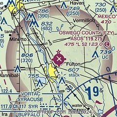
|
| Airport distance calculator |
|---|
|
|
| Sunrise and sunset |
|---|
|
Times for 14-Sep-2025
| | Local
(UTC-4) | | Zulu
(UTC) |
|---|
| Morning civil twilight | | 06:16 | | 10:16 |
| Sunrise | | 06:45 | | 10:45 |
| Sunset | | 19:17 | | 23:17 |
| Evening civil twilight | | 19:46 | | 23:46 |
|
| Current date and time |
|---|
| Zulu (UTC) | 14-Sep-2025 23:23:42 |
|---|
| Local (UTC-4) | 14-Sep-2025 19:23:42 |
|---|
|
| METAR |
|---|
| KFZY | 142254Z AUTO 33003KT 10SM CLR 20/14 A3012 RMK AO2 SLP198 T02000139
|
KSYR
19nm SE | 142254Z 33006KT 10SM FEW050 FEW200 22/13 A3011 RMK AO2 SLP191 T02170133 $
|
|
| TAF |
|---|
KSYR
19nm SE | 141724Z 1418/1518 VRB03KT P6SM SCT050 FM150100 VRB03KT P6SM FEW250 TEMPO 1510/1512 4SM BR FM151500 03004KT P6SM FEW035
|
|
| NOTAMs |
|---|
NOTAMs are issued by the DoD/FAA and will open in a separate window not controlled by AirNav.
|
|

